Difference between revisions of "January 13, 2008"
| Line 3: | Line 3: | ||
<!-- ws:start:WikiTextHeadingRule:0:<h2> --> | <!-- ws:start:WikiTextHeadingRule:0:<h2> --> | ||
<!-- ws:start:WikiTextLocalImageRule:2:<img src="/file/view/SchillerLPOD.jpg/34892191/SchillerLPOD.jpg" alt="" title="" /> -->[[File:SchillerLPOD.jpg|SchillerLPOD.jpg]]<!-- ws:end:WikiTextLocalImageRule:2 --><br /> | <!-- ws:start:WikiTextLocalImageRule:2:<img src="/file/view/SchillerLPOD.jpg/34892191/SchillerLPOD.jpg" alt="" title="" /> -->[[File:SchillerLPOD.jpg|SchillerLPOD.jpg]]<!-- ws:end:WikiTextLocalImageRule:2 --><br /> | ||
| − | <em>image by [mailto:CHRISTIAN.ARSIDI@wanadoo.fr | + | <em>image by [mailto:CHRISTIAN.ARSIDI@wanadoo.fr Christian Arsidi], Vernouillet, France.</em><br /> |
<br /> | <br /> | ||
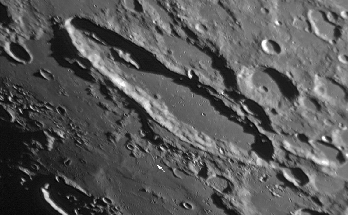
| − | This is a wonderful image of Schiller; unfortunately, I have nothing new to say about that landform. But limbward of Schiller (bottom left third of the image) is a fascinating feature with detail I hadn’t noticed before. The area covered with relatively smooth material is the floor of the [http://www.lpod.org/archive/LPOD-2004-10-17.htm | + | This is a wonderful image of Schiller; unfortunately, I have nothing new to say about that landform. But limbward of Schiller (bottom left third of the image) is a fascinating feature with detail I hadn’t noticed before. The area covered with relatively smooth material is the floor of the [http://www.lpod.org/archive/LPOD-2004-10-17.htm Schiller-Zucchius] three-ring basin. The [http://www.lpod.org/coppermine/displayimage.php?pid=3040&fullsize=1 main rim] (diameter 335 km) of the basin is well shown on the west and south sides, and the north-east end of the massive middle ring (175 km) is just visible as a finger near lower right. Most elusive is the 85 km wide inner ring, appearing like a mare ridge or a subtle turndown of the surface. Here, part of the ring is seen in unprecedented detail. Three small hills are on the eastern side of the inner ring, and inside them are two narrow and low ridges, cut in the middle by a small secondary crater cluster. I wish that this image continued across the basin so we could investigate its subtle topography everywhere! But there is also more of interest in areas we can see. Near the center-bottom of the image is a thin and short rille or crater chain (white arrow). The Orbiter IV [http://www.lpi.usra.edu/resources/lunarorbiter/images/preview/4155_h1.jpg image] shows this to be a line of closely spaced craters – probably secondary craters rather than volcanic collapse pits. Finally, the smooth material at upper left gives the impression of coating a rubbly underlying mterial, and in some places the smooth material seems to have collapsed. This is weird stuff – I doubt if it is basin ejecta.<br /> |
<br /> | <br /> | ||
<em>Chuck Wood</em><br /> | <em>Chuck Wood</em><br /> | ||
| Line 16: | Line 16: | ||
<strong>Related Links:</strong><br /> | <strong>Related Links:</strong><br /> | ||
Rükl plate 71 <br /> | Rükl plate 71 <br /> | ||
| − | [http://www.astronomike.net/fr_annuaire_auteur_24924_1.html | + | [http://www.astronomike.net/fr_annuaire_auteur_24924_1.html More of Christian's images]<br /> |
<br /> | <br /> | ||
| − | <em>Now you can support LPOD when you buy any book from Amazon thru [http://www.lpod.org/?page_id=591 | + | <em>Now you can support LPOD when you buy any book from Amazon thru [http://www.lpod.org/?page_id=591 LPOD!]</em> |
</div> | </div> | ||
---- | ---- | ||
===COMMENTS?=== | ===COMMENTS?=== | ||
| − | + | Register, and click on the <b>Discussion</b> tab at the top of the page. | |
Revision as of 16:06, 11 January 2015
Partially Seen, Totally Fascinating

image by Christian Arsidi, Vernouillet, France.
This is a wonderful image of Schiller; unfortunately, I have nothing new to say about that landform. But limbward of Schiller (bottom left third of the image) is a fascinating feature with detail I hadn’t noticed before. The area covered with relatively smooth material is the floor of the Schiller-Zucchius three-ring basin. The main rim (diameter 335 km) of the basin is well shown on the west and south sides, and the north-east end of the massive middle ring (175 km) is just visible as a finger near lower right. Most elusive is the 85 km wide inner ring, appearing like a mare ridge or a subtle turndown of the surface. Here, part of the ring is seen in unprecedented detail. Three small hills are on the eastern side of the inner ring, and inside them are two narrow and low ridges, cut in the middle by a small secondary crater cluster. I wish that this image continued across the basin so we could investigate its subtle topography everywhere! But there is also more of interest in areas we can see. Near the center-bottom of the image is a thin and short rille or crater chain (white arrow). The Orbiter IV image shows this to be a line of closely spaced craters – probably secondary craters rather than volcanic collapse pits. Finally, the smooth material at upper left gives the impression of coating a rubbly underlying mterial, and in some places the smooth material seems to have collapsed. This is weird stuff – I doubt if it is basin ejecta.
Chuck Wood
Note: You can use the "discussion" tab at the top to comment on this LPOD.
Technical Details:
Celestron 14 (355mm) + Titan 50 Losmandy mount + Barlow 2x + DMK 41AF02 camera, with 15 images a second, treatment with Iris.
Related Links:
Rükl plate 71
More of Christian's images
Now you can support LPOD when you buy any book from Amazon thru LPOD!
COMMENTS?
Register, and click on the Discussion tab at the top of the page.


