Difference between revisions of "May 9, 2004"
| Line 1: | Line 1: | ||
__NOTOC__ | __NOTOC__ | ||
=The Crater Formerly Known As Prinz= | =The Crater Formerly Known As Prinz= | ||
| − | + | <p align="center"> | |
| − | + | <table width="640" border="0" align="center" cellpadding="6" cellspacing="2"> | |
| − | + | <tr> | |
| − | + | </tr></table> | |
| − | |||
| − | |||
| − | |||
<table border="0" align="center" cellpadding="6" cellspacing="2"> | <table border="0" align="center" cellpadding="6" cellspacing="2"> | ||
| − | + | <tr> | |
| − | + | <td><div align="center">[[File:LPOD-2004-05-09.jpeg|LPOD-2004-05-09.jpeg]]</div></td> | |
| − | + | </tr> | |
| − | + | <tr> | |
| − | + | <td colspan="2"><div align="center"> | |
| − | + | <p class="main_sm">Image Credit: [mailto:kcpaulhk@yahoo.com.hk K.C. Pau]</p> | |
| − | + | </div></td> | |
| − | + | </tr> | |
| − | + | <table class="story" border="0" bgcolor="#FFFFFF" width="90%" cellpadding="10" align="center"> | |
| − | + | <tr> | |
| − | + | <td><p class="Story" align="center"><b><span class="class">The Crater Formerly Known As Prinz</span></b></p> | |
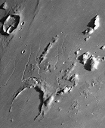
| − | + | <p class="story" align="left">Well, it actually still is known as Prinz. I can't say much about the crater itself - its a 47 km wide crater with a completely mare-flooded interior. The north rim of the crater rises a kilometer above the mare surface, but most of the southern rim is gone. Where did it go? The fact that the rim height smoothly decreases from north to south suggests that the crater either formed on a slope or, more likely, the terrain to the south subsided after Prinz formed. But I don't know why the south would subside, so perhaps the north has been uplifted. According to the topo contours in the Times Atlas of the Moon the high spot of this area is just north of Prinz, which is the source area for sinuous rilles beautifully captured in K.C. Pau's image. Rilles flow downslope, providing further evidence that the area immediately north of Prinz is high. I speculate that the magma that rose near the surface to feed the rilles also domed up the north side of Prinz. Piling speculation on speculation, the uplift also brought up portions of the rim of the Imbrium basin, which are the peaks visible on the upper right side of the image - the Harbinger Mountains! Maybe the Prinz uplift is a smaller and less structured version of the nearby Aristarchus Plateau uplift.</p> | |
| − | + | <p class="story" align="left"><b>Technical Details</b>:<br> | |
| − | + | May 1, 2004. 10" f/6 Newtonian + 5X Barlow + Phillips Toucam Pro; 114 stacked frames.</p> | |
| − | + | <p class="story"><b>Related Links:</b><br> | |
| − | + | [http://nssdc.gsfc.nasa.gov/imgcat/html/object_page/a15_m_2606.html Apollo 15 View]</p> | |
| − | + | <p class="story"><b>Tomorrow's LPOD:</b> Galileo's Colorful Moon</p> | |
| − | + | </tr> | |
| − | + | </table> | |
| − | + | <hr> | |
| − | + | <p align="center" class="main_titles"><b>Author & Editor:</b><br> | |
| − | + | [mailto:tychocrater@yahoo.com Charles A. Wood]</p> | |
| − | + | <p align="center" class="main_titles"><b>Technical Consultant:</b><br> | |
| − | + | [mailto:anthony@perseus.gr Anthony Ayiomamitis]</p> | |
| − | + | <p align="center" class="main_titles"><b>A service of:</b><br> | |
| − | + | [http://www.observingthesky.org/ ObservingTheSky.Org]</p> | |
| − | + | <p align="center" class="main_titles"><b>Visit these other PODs:</b> <br> | |
| − | + | [http://antwrp.gsfc.nasa.gov/apod/astropix.html Astronomy] | [http://www.msss.com/ Mars] | [http://epod.usra.edu/ Earth]</p> | |
| − | |||
| − | |||
| − | |||
| − | |||
<p> </p> | <p> </p> | ||
| − | |||
| − | |||
---- | ---- | ||
===COMMENTS?=== | ===COMMENTS?=== | ||
Click on this icon [[image:PostIcon.jpg]] at the upper right to post a comment. | Click on this icon [[image:PostIcon.jpg]] at the upper right to post a comment. | ||
Revision as of 17:20, 4 January 2015
The Crater Formerly Known As Prinz
Image Credit: K.C. Pau |
|
The Crater Formerly Known As Prinz Well, it actually still is known as Prinz. I can't say much about the crater itself - its a 47 km wide crater with a completely mare-flooded interior. The north rim of the crater rises a kilometer above the mare surface, but most of the southern rim is gone. Where did it go? The fact that the rim height smoothly decreases from north to south suggests that the crater either formed on a slope or, more likely, the terrain to the south subsided after Prinz formed. But I don't know why the south would subside, so perhaps the north has been uplifted. According to the topo contours in the Times Atlas of the Moon the high spot of this area is just north of Prinz, which is the source area for sinuous rilles beautifully captured in K.C. Pau's image. Rilles flow downslope, providing further evidence that the area immediately north of Prinz is high. I speculate that the magma that rose near the surface to feed the rilles also domed up the north side of Prinz. Piling speculation on speculation, the uplift also brought up portions of the rim of the Imbrium basin, which are the peaks visible on the upper right side of the image - the Harbinger Mountains! Maybe the Prinz uplift is a smaller and less structured version of the nearby Aristarchus Plateau uplift. Technical Details: Related Links: Tomorrow's LPOD: Galileo's Colorful Moon |
Author & Editor:
Charles A. Wood
Technical Consultant:
Anthony Ayiomamitis
A service of:
ObservingTheSky.Org
Visit these other PODs:
Astronomy | Mars | Earth
COMMENTS?
Click on this icon File:PostIcon.jpg at the upper right to post a comment.


