Difference between revisions of "March 11, 2014"
| Line 1: | Line 1: | ||
__NOTOC__ | __NOTOC__ | ||
=A Mega-Ridge= | =A Mega-Ridge= | ||
| − | |||
<!-- ws:start:WikiTextHeadingRule:0:<h1> --> | <!-- ws:start:WikiTextHeadingRule:0:<h1> --> | ||
<!-- ws:start:WikiTextLocalImageRule:6:<img src="/file/view/LPOD-Mar11-14.jpg/494897754/LPOD-Mar11-14.jpg" alt="" title="" /> -->[[File:LPOD-Mar11-14.jpg|LPOD-Mar11-14.jpg]]<!-- ws:end:WikiTextLocalImageRule:6 --><br /> | <!-- ws:start:WikiTextLocalImageRule:6:<img src="/file/view/LPOD-Mar11-14.jpg/494897754/LPOD-Mar11-14.jpg" alt="" title="" /> -->[[File:LPOD-Mar11-14.jpg|LPOD-Mar11-14.jpg]]<!-- ws:end:WikiTextLocalImageRule:6 --><br /> | ||
| − | <em>image by [mailto:mwirths@starband.net Michael Wirths], Baja California, Mexico</em><br /> | + | <em>image by [mailto:mwirths@starband.net" rel="nofollow Michael Wirths], Baja California, Mexico</em><br /> |
<br /> | <br /> | ||
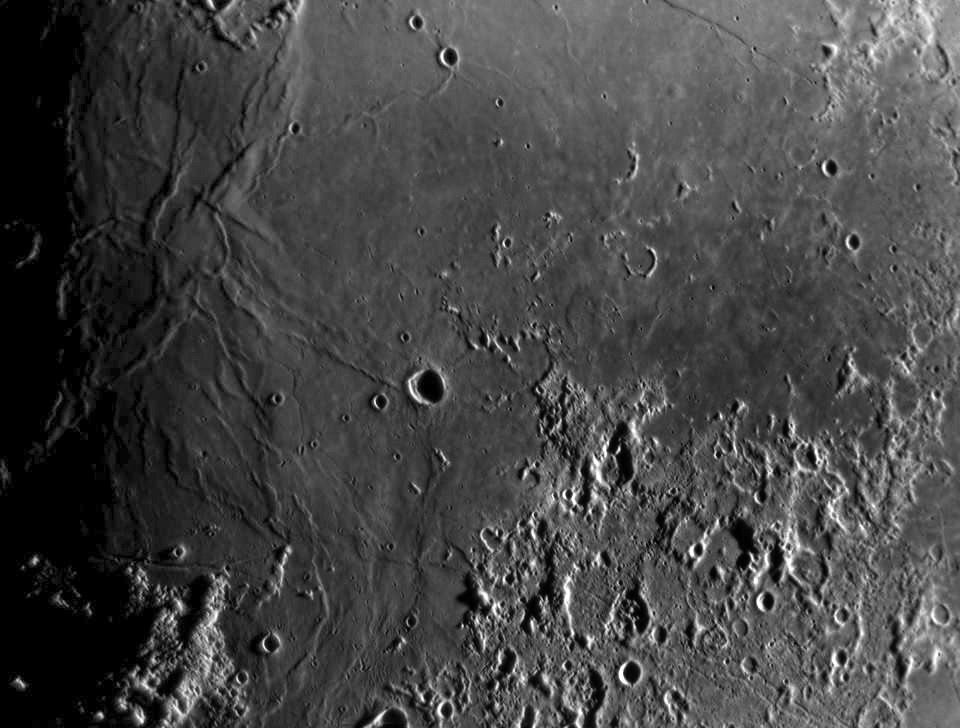
| − | Mike's wonderful new image of Tranquillitatis makes the Lamont region look like the gnarled hand of a hard worker. Narrow and wide ridges cause the mare surface to undulate at different wavelengths, a complexity that will evaporate with a slightly higher illumination into a flat dark lava plain. For me, the most interesting part of the image - meaning there is something seldom seen to enjoy and ponder - is the bottom half. In particular, the segmented broad ridge that crosses the south end of the mare between [http://bit.ly/1i1HTlQ Censorinus B and the Apollo 11 landing area]. At some places this is seen (courtesy of LRO QuickMap) to be a fault, whose north side rises 100-150 m. The linear tectonic feature is roughly continuous with the Guttenberg Rilles family, although the individual rilles are at a different angle. This family and the mare tectonic feature are radial to the center of Imbrium, as are the straight ridge from Maskelyne to Lamont, the ridge that crosses northern Lamont, and the Cauchy Fault. The basin's formation must have had some structural influence on the orientation of the ridges and fractures.<br /> | + | Mike's wonderful new image of Tranquillitatis makes the Lamont region look like the gnarled hand of a hard worker. Narrow and wide ridges cause the mare surface to undulate at different wavelengths, a complexity that will evaporate with a slightly higher illumination into a flat dark lava plain. For me, the most interesting part of the image - meaning there is something seldom seen to enjoy and ponder - is the bottom half. In particular, the segmented broad ridge that crosses the south end of the mare between [http://bit.ly/1i1HTlQ" rel="nofollow Censorinus B and the Apollo 11 landing area]. At some places this is seen (courtesy of LRO QuickMap) to be a fault, whose north side rises 100-150 m. The linear tectonic feature is roughly continuous with the Guttenberg Rilles family, although the individual rilles are at a different angle. This family and the mare tectonic feature are radial to the center of Imbrium, as are the straight ridge from Maskelyne to Lamont, the ridge that crosses northern Lamont, and the Cauchy Fault. The basin's formation must have had some structural influence on the orientation of the ridges and fractures.<br /> |
<br /> | <br /> | ||
| − | <em>[mailto:tychocrater@yahoo.com Chuck Wood]</em><br /> | + | <em>[mailto:tychocrater@yahoo.com" rel="nofollow Chuck Wood]</em><br /> |
<br /> | <br /> | ||
<strong>Technical Details</strong><br /> | <strong>Technical Details</strong><br /> | ||
| Line 15: | Line 14: | ||
<strong>Related Links</strong><br /> | <strong>Related Links</strong><br /> | ||
<em>[http://lpod.wikispaces.com/21st+Century+Atlas+of+the+Moon 21st Century Atlas]</em> chart 7.<br /> | <em>[http://lpod.wikispaces.com/21st+Century+Atlas+of+the+Moon 21st Century Atlas]</em> chart 7.<br /> | ||
| − | Mike's bed and breakfast astronomy [http://www.bajadarkskies.com website]<br /> | + | Mike's bed and breakfast astronomy [http://www.bajadarkskies.com" rel="nofollow website]<br /> |
<br /> | <br /> | ||
<hr /> | <hr /> | ||
Revision as of 21:57, 4 January 2015
A Mega-Ridge

image by " rel="nofollow Michael Wirths, Baja California, Mexico
Mike's wonderful new image of Tranquillitatis makes the Lamont region look like the gnarled hand of a hard worker. Narrow and wide ridges cause the mare surface to undulate at different wavelengths, a complexity that will evaporate with a slightly higher illumination into a flat dark lava plain. For me, the most interesting part of the image - meaning there is something seldom seen to enjoy and ponder - is the bottom half. In particular, the segmented broad ridge that crosses the south end of the mare between " rel="nofollow Censorinus B and the Apollo 11 landing area. At some places this is seen (courtesy of LRO QuickMap) to be a fault, whose north side rises 100-150 m. The linear tectonic feature is roughly continuous with the Guttenberg Rilles family, although the individual rilles are at a different angle. This family and the mare tectonic feature are radial to the center of Imbrium, as are the straight ridge from Maskelyne to Lamont, the ridge that crosses northern Lamont, and the Cauchy Fault. The basin's formation must have had some structural influence on the orientation of the ridges and fractures.
" rel="nofollow Chuck Wood
Technical Details
March 6, 2014
Related Links
21st Century Atlas chart 7.
Mike's bed and breakfast astronomy " rel="nofollow website


