Difference between revisions of "November 19, 2013"
| Line 1: | Line 1: | ||
__NOTOC__ | __NOTOC__ | ||
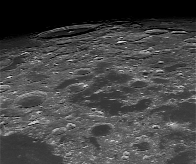
=Underarm View of Neper= | =Underarm View of Neper= | ||
| − | |||
<!-- ws:start:WikiTextHeadingRule:0:<h1> --> | <!-- ws:start:WikiTextHeadingRule:0:<h1> --> | ||
<!-- ws:start:WikiTextLocalImageRule:6:<img src="/file/view/LPOD-Nov19-13.jpg/470224924/LPOD-Nov19-13.jpg" alt="" title="" /> -->[[File:LPOD-Nov19-13.jpg|LPOD-Nov19-13.jpg]]<!-- ws:end:WikiTextLocalImageRule:6 --><br /> | <!-- ws:start:WikiTextLocalImageRule:6:<img src="/file/view/LPOD-Nov19-13.jpg/470224924/LPOD-Nov19-13.jpg" alt="" title="" /> -->[[File:LPOD-Nov19-13.jpg|LPOD-Nov19-13.jpg]]<!-- ws:end:WikiTextLocalImageRule:6 --><br /> | ||
| − | <em>east up image by [mailto:orquidarioavani@terra.com.br Avani Soares], Observatory Parsec, Canoas, Brazil</em><br /> | + | <em>east up image by [mailto:orquidarioavani@terra.com.br" rel="nofollow Avani Soares], Observatory Parsec, Canoas, Brazil</em><br /> |
<br /> | <br /> | ||
Recently we looked at a [http://lpod.wikispaces.com/November+17%2C+2013 region] between basin rings where all the craters were filled with lava. Here is another example, with the ring just as hard to see as for eastern Nectaris. The Crisium Basin has a reasonably well marked northern rim, if you know to look for it, but the rim on all other sides is largely missing. If you use the northern arc from Newcomb to Geminus through Hahn to draw a ring all around Crisium, the southern edge of the projected circle passes through Dubyago - the large dark-floored crater in the 3 pm position from the center of the image. So Mare Undarum and these flooded craters are in the moat between the massive ring that borders Mare Crisium and this geometrically defined rim to the south (right). Got that? But the swampiness also extends away from the basin moat, with scattered mare patches in Neper (11:30 position), and out of the image all the way towards the puddles of Mare Australe. Perhaps there are more buried basins - their fractures making conduits to the surface - in the lunar southeast quadrant than we have discovered - only [http://the-moon.wikispaces.com/Balmer-Kapteyn+Basin Balmer-Kapteyn] so far. <br /> | Recently we looked at a [http://lpod.wikispaces.com/November+17%2C+2013 region] between basin rings where all the craters were filled with lava. Here is another example, with the ring just as hard to see as for eastern Nectaris. The Crisium Basin has a reasonably well marked northern rim, if you know to look for it, but the rim on all other sides is largely missing. If you use the northern arc from Newcomb to Geminus through Hahn to draw a ring all around Crisium, the southern edge of the projected circle passes through Dubyago - the large dark-floored crater in the 3 pm position from the center of the image. So Mare Undarum and these flooded craters are in the moat between the massive ring that borders Mare Crisium and this geometrically defined rim to the south (right). Got that? But the swampiness also extends away from the basin moat, with scattered mare patches in Neper (11:30 position), and out of the image all the way towards the puddles of Mare Australe. Perhaps there are more buried basins - their fractures making conduits to the surface - in the lunar southeast quadrant than we have discovered - only [http://the-moon.wikispaces.com/Balmer-Kapteyn+Basin Balmer-Kapteyn] so far. <br /> | ||
<br /> | <br /> | ||
| − | <em>[mailto:tychocrater@yahoo.com Chuck Wood]</em><br /> | + | <em>[mailto:tychocrater@yahoo.com" rel="nofollow Chuck Wood]</em><br /> |
<br /> | <br /> | ||
<strong>Technical Details</strong><br /> | <strong>Technical Details</strong><br /> | ||
Revision as of 21:52, 4 January 2015
Underarm View of Neper

east up image by " rel="nofollow Avani Soares, Observatory Parsec, Canoas, Brazil
Recently we looked at a region between basin rings where all the craters were filled with lava. Here is another example, with the ring just as hard to see as for eastern Nectaris. The Crisium Basin has a reasonably well marked northern rim, if you know to look for it, but the rim on all other sides is largely missing. If you use the northern arc from Newcomb to Geminus through Hahn to draw a ring all around Crisium, the southern edge of the projected circle passes through Dubyago - the large dark-floored crater in the 3 pm position from the center of the image. So Mare Undarum and these flooded craters are in the moat between the massive ring that borders Mare Crisium and this geometrically defined rim to the south (right). Got that? But the swampiness also extends away from the basin moat, with scattered mare patches in Neper (11:30 position), and out of the image all the way towards the puddles of Mare Australe. Perhaps there are more buried basins - their fractures making conduits to the surface - in the lunar southeast quadrant than we have discovered - only Balmer-Kapteyn so far.
" rel="nofollow Chuck Wood
Technical Details
Nov. 18, 2013, 02:43 UT. GSO 12" + QHY 5L colour + IR Pass 742 + Contrast Booster. Stack 270 frameros in AS!2. Post processing Photofiltre and Irfan.
Related Links
21st Century Atlas chart 2.


