Difference between revisions of "February 10, 2009"
| Line 6: | Line 6: | ||
<em>south up drawing by [mailto:philip.morgan@talktalk.net Philip Morgan]</em><br /> | <em>south up drawing by [mailto:philip.morgan@talktalk.net Philip Morgan]</em><br /> | ||
<br /> | <br /> | ||
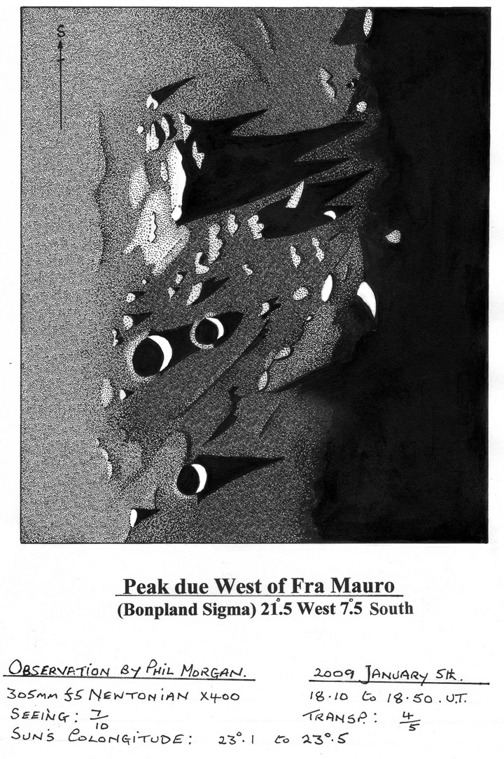
| − | The prominent mountain at the centre bottom (south) of the [http://lpod. | + | The prominent mountain at the centre bottom (south) of the [http://www2.lpod.org/wiki/February_7,_2009 February 7] LPOD looks like Bonpland Sigma. I've just completed a recent study of the region, and found it to be much more interesting than would be indicated by the total lack of observational material by past visual observers. At the time of the observation I was impressed with the magnificent spires of shadow sweeping westwards towards the terminator from the Bonpland Sigma peak, but as is often the case it is when you compare your observation with maps and photographs afterwards that points of interest come to light. For example Rukl's Atlas shows three distinct craterlets at the southern tip of Sigma, but these were completely missed by myself on this occasion, though on the Times Atlas they don't appear quite so distinct. This Atlas also shows a distinct rille running to the northeast from the Southeastern end of this peak - again I was unable to find this, and I don't see it on the Orbiter shots either. I did however, record a gully running in a similar direction from the North and cutting through the lighter raised ground that I show abutting to the East of Sigma.On the Orbiter shots as well as the LPOD, there is a long gully or trench running due north from this northern end, but this doesn't appear to be the feature that I noted (unless I completely misplaced it). So some interesting anomalies to try and sort out on a future occasion!<br /> |
<br /> | <br /> | ||
<em>[mailto:philip.morgan@talktalk.net Philip Morgan]</em><br /> | <em>[mailto:philip.morgan@talktalk.net Philip Morgan]</em><br /> | ||
Latest revision as of 07:26, 28 October 2018
Tapering Towards the Terminator

south up drawing by Philip Morgan
The prominent mountain at the centre bottom (south) of the February 7 LPOD looks like Bonpland Sigma. I've just completed a recent study of the region, and found it to be much more interesting than would be indicated by the total lack of observational material by past visual observers. At the time of the observation I was impressed with the magnificent spires of shadow sweeping westwards towards the terminator from the Bonpland Sigma peak, but as is often the case it is when you compare your observation with maps and photographs afterwards that points of interest come to light. For example Rukl's Atlas shows three distinct craterlets at the southern tip of Sigma, but these were completely missed by myself on this occasion, though on the Times Atlas they don't appear quite so distinct. This Atlas also shows a distinct rille running to the northeast from the Southeastern end of this peak - again I was unable to find this, and I don't see it on the Orbiter shots either. I did however, record a gully running in a similar direction from the North and cutting through the lighter raised ground that I show abutting to the East of Sigma.On the Orbiter shots as well as the LPOD, there is a long gully or trench running due north from this northern end, but this doesn't appear to be the feature that I noted (unless I completely misplaced it). So some interesting anomalies to try and sort out on a future occasion!
Philip Morgan
Technical Details
See drawing
Related Links
Rükl plate 42
Yesterday's LPOD: Burying Craters
Tomorrow's LPOD: Jumbilation
COMMENTS?
Register, Log in, and join in the comments.


