Difference between revisions of "September 26, 2013"
| (3 intermediate revisions by the same user not shown) | |||
| Line 1: | Line 1: | ||
__NOTOC__ | __NOTOC__ | ||
=Rilles And Basins= | =Rilles And Basins= | ||
| + | <!-- Start of content --> | ||
<!-- ws:start:WikiTextHeadingRule:0:<h1> --> | <!-- ws:start:WikiTextHeadingRule:0:<h1> --> | ||
<!-- ws:start:WikiTextLocalImageRule:6:<img src="/file/view/LPOD-Sept26-13.jpg/454233822/LPOD-Sept26-13.jpg" alt="" title="" /> -->[[File:LPOD-Sept26-13.jpg|LPOD-Sept26-13.jpg]]<!-- ws:end:WikiTextLocalImageRule:6 --><br /> | <!-- ws:start:WikiTextLocalImageRule:6:<img src="/file/view/LPOD-Sept26-13.jpg/454233822/LPOD-Sept26-13.jpg" alt="" title="" /> -->[[File:LPOD-Sept26-13.jpg|LPOD-Sept26-13.jpg]]<!-- ws:end:WikiTextLocalImageRule:6 --><br /> | ||
<em>north to the right image by [mailto:gtarsoudis@gmail.com George Tarsoudis], Greece</em><br /> | <em>north to the right image by [mailto:gtarsoudis@gmail.com George Tarsoudis], Greece</em><br /> | ||
<br /> | <br /> | ||
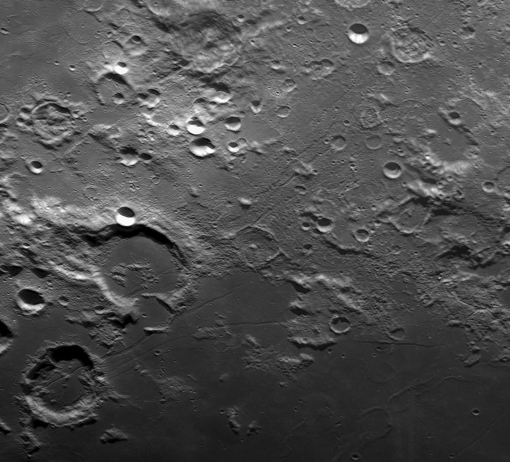
| − | I think the Moon must be closer to Earth when it is over Greece because George has been consistently obtaining remarkable images. This LPOD is just a piece of a larger [http://www.lunar-captures.com//craters_G_files/130922_Gutenberg_Tar.jpg mosaic] but it is a very instructive because the terrain is so fascinating. Although Apollo 8 stunned the world with an awesome image of the rilles that cut the crater [ | + | I think the Moon must be closer to Earth when it is over Greece because George has been consistently obtaining remarkable images. This LPOD is just a piece of a larger [http://www.lunar-captures.com//craters_G_files/130922_Gutenberg_Tar.jpg mosaic] but it is a very instructive because the terrain is so fascinating. Although Apollo 8 stunned the world with an awesome image of the rilles that cut the crater [https://the-moon.us/wiki/Goclenius Goclenius] (bottom left), George provides a detailed view of rilled terrain from there all along the boundary of two basins - Nectaris and Fecunditatis. The two major [https://the-moon.us/wiki/Rimae_Goclenius Goclenius Rilles] near the center of the image seem to be associated with different structural features. The lower rille curves downward as if it is concentric to the putative Fecunditatis Basin, whereas the upper rille sails past without a bend. The upper rille parallels the [https://the-moon.us/wiki/Rimae_Gutenberg Gutenberg Rilles] that faintly cross the southern surround of the Nectaris Basin as if they don't belong there. In fact, they - like the [https://the-moon.us/wiki/Vallis_Capella Capella Valley] at center left top - are aligned radially with the Imbrium Basin. The Valley is an Imbrium Basin crater chain, and the rilles may mark regions of Imbrium related stress release. There are many other fascinating features here to explore on your own, but I want to call attention to the unnamed rille that casts a shadow where the two Messier rays meet it. According to the altimetry from the [http://bit.ly/1bdhZLR LRO Quickmap] the western (top in this image) side of the rille is about 120 m higher than the eastern side. I suggest that we call this unusual feature the Lubbock Rille after the shadowed crater to the left. George's image also captures the poorly known, small scale rilles and pit chains just west of the Lubbock Rille.<br /> |
<br /> | <br /> | ||
<em>[mailto:tychocrater@yahoo.com Chuck Wood]</em><br /> | <em>[mailto:tychocrater@yahoo.com Chuck Wood]</em><br /> | ||
| Line 13: | Line 14: | ||
<br /> | <br /> | ||
<strong>Related Links</strong><br /> | <strong>Related Links</strong><br /> | ||
| − | <em>[ | + | <em>[[21st Century Atlas of the Moon|21st Century Atlas]]</em> charts 3, 7.<br /> |
George's [http://www.lunar-captures.com website]<br /> | George's [http://www.lunar-captures.com website]<br /> | ||
<br /> | <br /> | ||
Latest revision as of 07:37, 28 October 2018
Rilles And Basins

north to the right image by George Tarsoudis, Greece
I think the Moon must be closer to Earth when it is over Greece because George has been consistently obtaining remarkable images. This LPOD is just a piece of a larger mosaic but it is a very instructive because the terrain is so fascinating. Although Apollo 8 stunned the world with an awesome image of the rilles that cut the crater Goclenius (bottom left), George provides a detailed view of rilled terrain from there all along the boundary of two basins - Nectaris and Fecunditatis. The two major Goclenius Rilles near the center of the image seem to be associated with different structural features. The lower rille curves downward as if it is concentric to the putative Fecunditatis Basin, whereas the upper rille sails past without a bend. The upper rille parallels the Gutenberg Rilles that faintly cross the southern surround of the Nectaris Basin as if they don't belong there. In fact, they - like the Capella Valley at center left top - are aligned radially with the Imbrium Basin. The Valley is an Imbrium Basin crater chain, and the rilles may mark regions of Imbrium related stress release. There are many other fascinating features here to explore on your own, but I want to call attention to the unnamed rille that casts a shadow where the two Messier rays meet it. According to the altimetry from the LRO Quickmap the western (top in this image) side of the rille is about 120 m higher than the eastern side. I suggest that we call this unusual feature the Lubbock Rille after the shadowed crater to the left. George's image also captures the poorly known, small scale rilles and pit chains just west of the Lubbock Rille.
Chuck Wood
Technical Details
Sept 22, 2013. Telescope SkyWatcher 14 inch @f/4.5, camera Unibrain Fire-i 785, filter Red, barlow 3X, mosaic 3 images.
Related Links
21st Century Atlas charts 3, 7.
George's website
Yesterday's LPOD: Is It or Isn't It?
Tomorrow's LPOD: Sculpted Floor
COMMENTS?
Register, Log in, and join in the comments.


