Difference between revisions of "July 17, 2012"
| (4 intermediate revisions by the same user not shown) | |||
| Line 1: | Line 1: | ||
__NOTOC__ | __NOTOC__ | ||
=Creases, Cracks, Fractures And Inflections= | =Creases, Cracks, Fractures And Inflections= | ||
| + | <!-- Start of content --> | ||
<!-- ws:start:WikiTextHeadingRule:0:<h1> --> | <!-- ws:start:WikiTextHeadingRule:0:<h1> --> | ||
<!-- ws:start:WikiTextLocalImageRule:6:<img src="http://lpod.wikispaces.com/file/view/LPOD-Jul17-12.jpg/353129144/LPOD-Jul17-12.jpg" alt="" title="" /> -->[[File:LPOD-Jul17-12.jpg|LPOD-Jul17-12.jpg]]<!-- ws:end:WikiTextLocalImageRule:6 --><br /> | <!-- ws:start:WikiTextLocalImageRule:6:<img src="http://lpod.wikispaces.com/file/view/LPOD-Jul17-12.jpg/353129144/LPOD-Jul17-12.jpg" alt="" title="" /> -->[[File:LPOD-Jul17-12.jpg|LPOD-Jul17-12.jpg]]<!-- ws:end:WikiTextLocalImageRule:6 --><br /> | ||
| Line 19: | Line 20: | ||
<br /> | <br /> | ||
<strong>Related Links</strong><br /> | <strong>Related Links</strong><br /> | ||
| − | Rükl plate [ | + | Rükl plate [https://the-moon.us/wiki/R%C3%BCkl_54 54]<br /> |
Times Atlas of the Moon plate 82<br /> | Times Atlas of the Moon plate 82<br /> | ||
<br /> | <br /> | ||
| + | <p><b>Yesterday's LPOD:</b> [[July 16, 2012|Moon Eats Planet Party]] </p> | ||
| + | <p><b>Tomorrow's LPOD:</b> [[July 18, 2012|Bright Hole]] </p> | ||
<hr /> | <hr /> | ||
| + | {{wiki/ArticleFooter}} | ||
Latest revision as of 17:48, 13 October 2018
Creases, Cracks, Fractures And Inflections

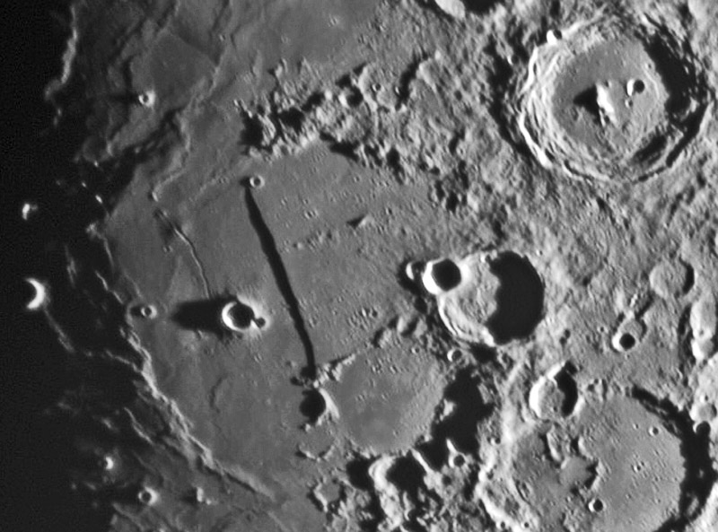
image by Ralph Ford, Redondo Beach, California, USA
This image does an excellent job of showing all of the major and subtle linear features near the Straight Wall. Using the LRO QuickMap altimetry tool (Path) we can now attach measurements to these markings.
1. First, the Wall itself, a prominent scarp whose east side rises about 400 m above the western half. What isn't obvious is that the the surface west of the Wall has a much steeper (about 5 times) westward slope downward than the land east of the scarp. In fact, there is a greater decrease in elevation - about 500 m - west of the scarp than down the scarp itself.
2. Moving to the Birt Rille, which cuts a big and a little dome at its north end, I find that it is about 90 m deep. However, a traverse across the big dome shows the dome to be about 150 m high, but the rille is 600 m deep. Wow - this must be going down into the volcanic vent that was the lava source for both the dome and the rille.
3. South and a little west of Birt is a delicate linear depression about 10 m deep. Detection of such a shallow feature demonstrates the power of low Sun magnification of topography.
4. Perpendicular to a place about 25% below the north end of the Straight Wall is another very delicate cleft running to the east, northeast. This feature is also only 10 m deep. It looks like a rille that has been infilled with later lava.
5. At the top left of the image is another linear feature heading off to the northwest. It is clearly there as a crease or a buried rille, but I can not measure a depth for it.
6. There is one more significant break of the crust in this image (not counting crater rims!) - I measure it to be a fault with the west side about 200 m higher than the east. Do you see it?
Chuck Wood
Technical Details
May 28, 2012. 8" F/6 Newtonian + 1.8X barlow lens + Imaging Source DMK 21AU04.AS video camera, video frames were stacked and processed with RegiStax.
Related Links
Rükl plate 54
Times Atlas of the Moon plate 82
Yesterday's LPOD: Moon Eats Planet Party
Tomorrow's LPOD: Bright Hole
COMMENTS?
Register, Log in, and join in the comments.


