Difference between revisions of "July 2, 2004"
| (14 intermediate revisions by the same user not shown) | |||
| Line 1: | Line 1: | ||
__NOTOC__ | __NOTOC__ | ||
=Boring (?)= | =Boring (?)= | ||
| − | + | <!-- Start of content --> | |
| − | + | <table width="85%" border="0" align="center" cellpadding="6" cellspacing="2"> | |
| − | + | <tr> | |
| − | + | </tr> | |
| − | + | </table> | |
| − | + | <table width="85%" border="0" align="center" cellpadding="6" cellspacing="2"> | |
| − | + | <tr> | |
| − | + | <td colspan="2"><div align="center"> | |
| − | + | {{HoverImage|LPOD-2004-07-02.jpeg|LPOD-2004-07-02b.JPG}} | |
| − | + | </div></td> | |
| − | + | </tr> | |
| − | |||
| − | |||
| − | |||
</table> | </table> | ||
<table width="100%" border="0" cellpadding="8"> | <table width="100%" border="0" cellpadding="8"> | ||
| − | + | <tr> | |
| − | + | <td><div align="center"><p>Image Credit: [mailto:thefamily90@hotmail.com Jim Phillips]</p></div></td> | |
| − | + | </tr> | |
</table> | </table> | ||
| − | + | <table class="story" border="0" bgcolor="#FFFFFF" width="90%" cellpadding="10" align="center"><tr><td> | |
| − | + | <p class="story" align="center"><b>Boring (?) </b></p> | |
| − | + | <p class="story" align="left"> | |
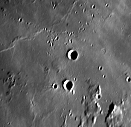
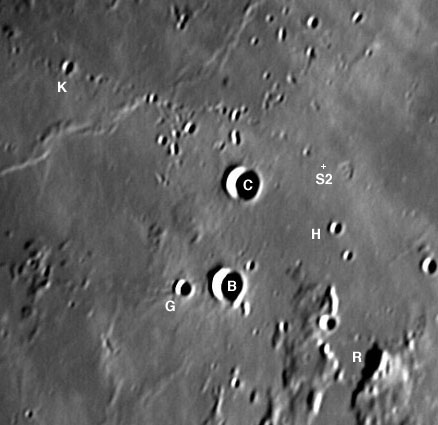
| − | + | Most images published by LPOD are dramatic views of craters, volcanoes or lunar mountains, but this one is of a pretty bland section of Mare Insularum near the crater Gambart. Is LPOD really so desperate for lunar images? No, but we do need more good ones ASAP! I'm using this image as a challenge to demonstrate that every place on the Moon has a story to tell. Take a look, what do you see? ...... Most of the surface is smooth mare lavas with a few wrinkle ridges and a low irregular rise between the two craters, Gambart B and C (diameter 11.8 km). Hills occur in clumps, the biggest grouping in the southeast where they form the supposed rims of a crater generously given the designation Sommering R (for ruin). A number of wispy light-hued streaks cross the area, apparently coming from the northwest. Aligned along some of these streaks are small craters, many of which are elongated or doubles. Here is what these observations tell us. Lavas of about the same age as those in Mare Imbrium flooded this area, covering and oozing around hilly ejecta from the formation of the Imbrium basin 3.85 billion years ago. Sommering R is the remnant of a crater that may have been damaged by the Imbrium ejecta as well as by these lavas. A local vent (source of lava) erupted a lava that probably was more viscous than the mare lavas and didn't flow far, building a low, rough surfaced dome. About 1.1 billion year ago Copernicus formed off to the upper left and this area received a shot gun-like blast of secondary ejecta and rays. We can't tell when the young lettered craters formed, perhaps after Copernicus, but we do know that an out-of-control Surveyor spacecraft crashed here on Sept 22, 1966. And on June 26, Jim Phillips took a picture of a bland area with a dome!</p> | |
| − | + | <blockquote> | |
| − | + | <p align="right" class="story">— [mailto:tychocrater@yahoo.com Chuck Wood]</p></blockquote> | |
| − | + | <p class="story" align="left"><b>Technical Details:</b><br> | |
| − | + | June 26, 2004; TMB 8" F/9 apo, Philips Toucam Pro webcam, Registax. 3X barlow.<br> | |
| − | + | All lettered craters refer to Gambart except Sommering R. | |
| − | + | </p> | |
| − | + | <p class="story" align="left"><b>Related Links: </b><br> | |
| − | + | [http://www.lpi.usra.edu/research/lunar_orbiter/images/img/iv_114_h1.jpg Lunar Orbiter IV View ]</p> | |
| − | + | <p><b>Yesterday's LPOD:</b> [[July 1, 2004|Apollo Metrics]] </p> | |
| − | + | <p><b>Tomorrow's LPOD:</b> [[July 3, 2004|Moving Moon]] </p> | |
| − | + | </tr> | |
| − | |||
</table> | </table> | ||
| − | + | <!-- start bottom --> | |
| − | < | + | <table width="100%" border="0" cellspacing="2" cellpadding="4"> |
| − | |||
| − | |||
<tr> | <tr> | ||
| − | + | <td><hr></td> | |
| − | + | </tr> | |
| − | + | <tr> | |
| − | + | <td><p align="center" class="main_titles"><b>Author & Editor:</b><br> | |
| − | + | [mailto:tychocrater@yahoo.com Charles A. Wood]</p> | |
| − | + | <!-- Cleanup of credits --> | |
| − | + | <!-- Cleanup of credits --> | |
| − | + | <!-- Cleanup of credits --> | |
| − | + | <!-- Cleanup of credits --> | |
| − | + | <!-- Cleanup of credits --> | |
| − | + | <!-- Cleanup of credits --> | |
| − | + | <!-- Cleanup of credits --> | |
| − | + | </tr> | |
| − | + | </table> | |
| − | + | <!-- end cal --> | |
| − | + | <div align="center"></div> | |
| − | |||
| − | |||
| − | |||
| − | |||
| − | |||
| − | |||
<p> </p> | <p> </p> | ||
| − | + | <!-- End of content --> | |
| − | + | {{wiki/ArticleFooter}} | |
| − | |||
| − | ---- | ||
| − | |||
| − | |||
Latest revision as of 21:39, 8 February 2015
Boring (?)
Image Credit: Jim Phillips |
|
Boring (?) Most images published by LPOD are dramatic views of craters, volcanoes or lunar mountains, but this one is of a pretty bland section of Mare Insularum near the crater Gambart. Is LPOD really so desperate for lunar images? No, but we do need more good ones ASAP! I'm using this image as a challenge to demonstrate that every place on the Moon has a story to tell. Take a look, what do you see? ...... Most of the surface is smooth mare lavas with a few wrinkle ridges and a low irregular rise between the two craters, Gambart B and C (diameter 11.8 km). Hills occur in clumps, the biggest grouping in the southeast where they form the supposed rims of a crater generously given the designation Sommering R (for ruin). A number of wispy light-hued streaks cross the area, apparently coming from the northwest. Aligned along some of these streaks are small craters, many of which are elongated or doubles. Here is what these observations tell us. Lavas of about the same age as those in Mare Imbrium flooded this area, covering and oozing around hilly ejecta from the formation of the Imbrium basin 3.85 billion years ago. Sommering R is the remnant of a crater that may have been damaged by the Imbrium ejecta as well as by these lavas. A local vent (source of lava) erupted a lava that probably was more viscous than the mare lavas and didn't flow far, building a low, rough surfaced dome. About 1.1 billion year ago Copernicus formed off to the upper left and this area received a shot gun-like blast of secondary ejecta and rays. We can't tell when the young lettered craters formed, perhaps after Copernicus, but we do know that an out-of-control Surveyor spacecraft crashed here on Sept 22, 1966. And on June 26, Jim Phillips took a picture of a bland area with a dome! Technical Details: Related Links: Yesterday's LPOD: Apollo Metrics Tomorrow's LPOD: Moving Moon |
Author & Editor: |
COMMENTS?
Register, Log in, and join in the comments.


