Difference between revisions of "December 30, 2009"
| Line 2: | Line 2: | ||
=Hyginus Depression= | =Hyginus Depression= | ||
| − | + | <!-- ws:start:WikiTextHeadingRule:1:<h1> --> | |
| − | + | <!-- ws:start:WikiTextLocalImageRule:16:<img src="/file/view/LPOD-Dec30-09.jpg/111230737/LPOD-Dec30-09.jpg" alt="" title="" /> -->[[File:LPOD-Dec30-09.jpg|LPOD-Dec30-09.jpg]]<!-- ws:end:WikiTextLocalImageRule:16 --><br /> | |
<em>left image by [mailto:slamm@blueyonder.co.uk Stefan Lammel] and right map from LPI [http://www.lpi.usra.edu/resources/mapcatalog/LAC/lac59/ Map Catalog]</em><br /> | <em>left image by [mailto:slamm@blueyonder.co.uk Stefan Lammel] and right map from LPI [http://www.lpi.usra.edu/resources/mapcatalog/LAC/lac59/ Map Catalog]</em><br /> | ||
<br /> | <br /> | ||
| Line 18: | Line 18: | ||
<br /> | <br /> | ||
<hr /> | <hr /> | ||
| − | + | <div>You can support LPOD when you buy any book from Amazon thru [http://www.lpod.org/?page_id=591 LPOD!]<br /> | |
| − | + | </div> | |
---- | ---- | ||
===COMMENTS?=== | ===COMMENTS?=== | ||
Click on this icon [[image:PostIcon.jpg]] at the upper right to post a comment. | Click on this icon [[image:PostIcon.jpg]] at the upper right to post a comment. | ||
Revision as of 22:53, 2 January 2015
Hyginus Depression

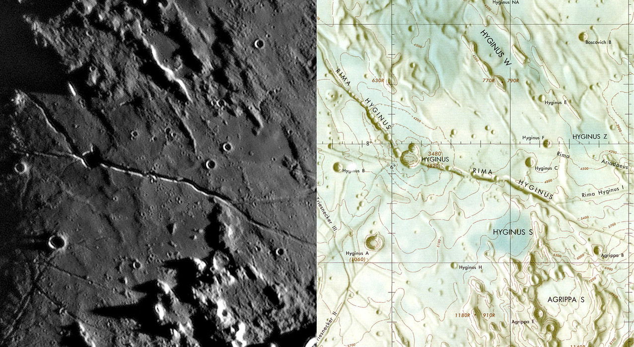
left image by Stefan Lammel and right map from LPI Map Catalog
Today I came across this old (1966) LAC chart (right) of the Hyginus region, and was impressed that, according to the contours, the Hyginus crater was at the center of a 120 km long, 2 km deep, depression. If ever the surrounding plain had been full of liquid lava it would have drained into Hyginus. This depression adds another element to the story of the lunar crater least likely to be of impact origin. Hyginus is 9 km wide, rimless and at the intersection of the two main arms of the Hyginus Rille, and of the continuation westward of the eastern rille, and another narrow one coming up from the Triesnecker area. At high Sun, a broad dark halo envelopes Hyginus, with spectral and radar properties of a pyroclastic deposit - volcanic ash. In Hawaii, chains of collapse pits occur along the top of a subsurface conduit that carries magma away from its deeper source, and overlying caldera, toward the volcano flanks. Could Hyginus be the caldera over a deep magma source, and the main rilles be collapses into deeper conduits that distributed magma to Mare Vaporum, and (less likely) to Mare Tranquillitatis? In Hawaii, the caldera is the highest elevation of the volcano; Hyginus is the lowest. Perhaps, to carry this speculation further, as magma erupted from the source deep under Hyginus, the overlying roof subsided, creating the broad depression. This would be a compelling interpretation if there were concentric rilles at the edges of the depressed zones, but there aren't. Although the existence of the depression is not critical to the drainage theory - it just inspired me! - Kaguya altimetry data does not confirm these LAC contours. If Kaguya is correct, no subsidence occurred and concentric rilles would not be expected!
Chuck Wood
Technical Details
The image is an excerpt from the March 3, 2008 LPOD.
Related Links
Rükl plate 34
Hawke and Coombs (1987) Remote sensing studies of the Rima Hyginus region of the Moon. 18th LPSC, 407.
COMMENTS?
Click on this icon File:PostIcon.jpg at the upper right to post a comment.


