Difference between revisions of "September 27, 2013"
| (One intermediate revision by the same user not shown) | |||
| Line 1: | Line 1: | ||
__NOTOC__ | __NOTOC__ | ||
=Sculpted Floor= | =Sculpted Floor= | ||
| + | <!-- Start of content --> | ||
<!-- ws:start:WikiTextHeadingRule:0:<h1> --> | <!-- ws:start:WikiTextHeadingRule:0:<h1> --> | ||
<!-- ws:start:WikiTextLocalImageRule:6:<img src="/file/view/LPOD-Sept27-13.jpg/454535180/LPOD-Sept27-13.jpg" alt="" title="" /> -->[[File:LPOD-Sept27-13.jpg|LPOD-Sept27-13.jpg]]<!-- ws:end:WikiTextLocalImageRule:6 --><br /> | <!-- ws:start:WikiTextLocalImageRule:6:<img src="/file/view/LPOD-Sept27-13.jpg/454535180/LPOD-Sept27-13.jpg" alt="" title="" /> -->[[File:LPOD-Sept27-13.jpg|LPOD-Sept27-13.jpg]]<!-- ws:end:WikiTextLocalImageRule:6 --><br /> | ||
<em>north to the right image by [mailto:gari@adbooth.net Gari Arrillaga]</em>, Tarragona, Spain<br /> | <em>north to the right image by [mailto:gari@adbooth.net Gari Arrillaga]</em>, Tarragona, Spain<br /> | ||
<br /> | <br /> | ||
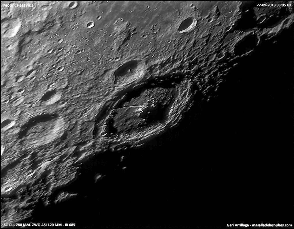
| − | I have seen a lot of wonderful images of Petavius but this is unlike any of the previous ones. The illumination is low enough to highlight numerous hills that we have seen [http://lpod. | + | I have seen a lot of wonderful images of Petavius but this is unlike any of the previous ones. The illumination is low enough to highlight numerous hills that we have seen [http://www2.lpod.org/wiki/July_26,_2013 before] but not with such a sense of topograpgic clarity. The southern half of the floor, which often looks relatively smooth, is seen to have long wavelength undulations than make up a different type of relief than the hills. Gari's images clarifies something else we have discussed [http://www2.lpod.org/wiki/April_26,_2011 before]: The main mass of its floor is higher than its edges. This images shows a well- defined trough with lava-covered floor from the north around at least to the northeast. The southeast edge of the floor also appears low but it isn't filled with smooth material. The [http://bit.ly/18tr6SI LRO QuickMap] altimetry confirms the lowness of these edges but not nearly as dramatically as this image. <br /> |
<br /> | <br /> | ||
<em>[mailto:tychocrater@yahoo.com Chuck Wood]</em><br /> | <em>[mailto:tychocrater@yahoo.com Chuck Wood]</em><br /> | ||
<br /> | <br /> | ||
<strong>Related Links</strong>]<br /> | <strong>Related Links</strong>]<br /> | ||
| − | <em>[ | + | <em>[[21st Century Atlas of the Moon|21st Century Atlas]]</em> chart 4.<br /> |
Gari's [http://masalladelasnubes.com website]<br /> | Gari's [http://masalladelasnubes.com website]<br /> | ||
<br /> | <br /> | ||
Latest revision as of 07:37, 28 October 2018
Sculpted Floor

north to the right image by Gari Arrillaga, Tarragona, Spain
I have seen a lot of wonderful images of Petavius but this is unlike any of the previous ones. The illumination is low enough to highlight numerous hills that we have seen before but not with such a sense of topograpgic clarity. The southern half of the floor, which often looks relatively smooth, is seen to have long wavelength undulations than make up a different type of relief than the hills. Gari's images clarifies something else we have discussed before: The main mass of its floor is higher than its edges. This images shows a well- defined trough with lava-covered floor from the north around at least to the northeast. The southeast edge of the floor also appears low but it isn't filled with smooth material. The LRO QuickMap altimetry confirms the lowness of these edges but not nearly as dramatically as this image.
Chuck Wood
Related Links]
21st Century Atlas chart 4.
Gari's website
Yesterday's LPOD: Rilles And Basins
Tomorrow's LPOD: Extreme Makeover
COMMENTS?
Register, Log in, and join in the comments.


