Difference between revisions of "September 21, 2014"
| (4 intermediate revisions by the same user not shown) | |||
| Line 1: | Line 1: | ||
__NOTOC__ | __NOTOC__ | ||
=A Crater Without an Owner= | =A Crater Without an Owner= | ||
| + | <!-- Start of content --> | ||
<!-- ws:start:WikiTextHeadingRule:0:<h1> --> | <!-- ws:start:WikiTextHeadingRule:0:<h1> --> | ||
<!-- ws:start:WikiTextLocalImageRule:6:<img src="/file/view/LPOD-sep21-14.jpg/523103502/LPOD-sep21-14.jpg" alt="" title="" /> -->[[File:LPOD-sep21-14.jpg|LPOD-sep21-14.jpg]]<!-- ws:end:WikiTextLocalImageRule:6 --><br /> | <!-- ws:start:WikiTextLocalImageRule:6:<img src="/file/view/LPOD-sep21-14.jpg/523103502/LPOD-sep21-14.jpg" alt="" title="" /> -->[[File:LPOD-sep21-14.jpg|LPOD-sep21-14.jpg]]<!-- ws:end:WikiTextLocalImageRule:6 --><br /> | ||
| Line 14: | Line 15: | ||
<br /> | <br /> | ||
<strong>Related Links</strong><br /> | <strong>Related Links</strong><br /> | ||
| − | <em>[ | + | <em>[[21st Century Atlas of the Moon|21st Century Atlas]]</em> chart 8.<br /> |
| − | Ricardo's [/www.vaztolentino.com.br website]<br /> | + | Ricardo's [http://www.vaztolentino.com.br website]<br /> |
<br /> | <br /> | ||
| − | <p><b>Yesterday's LPOD:</b> [[September 20, 2014|Over the Pole | + | <p><b>Yesterday's LPOD:</b> [[September 20, 2014|Over the Pole and in the Hole]] </p> |
<p><b>Tomorrow's LPOD:</b> [[September 22, 2014|T-Rex Smile]] </p> | <p><b>Tomorrow's LPOD:</b> [[September 22, 2014|T-Rex Smile]] </p> | ||
<hr /> | <hr /> | ||
| + | {{wiki/ArticleFooter}} | ||
Latest revision as of 07:37, 28 October 2018
A Crater Without an Owner

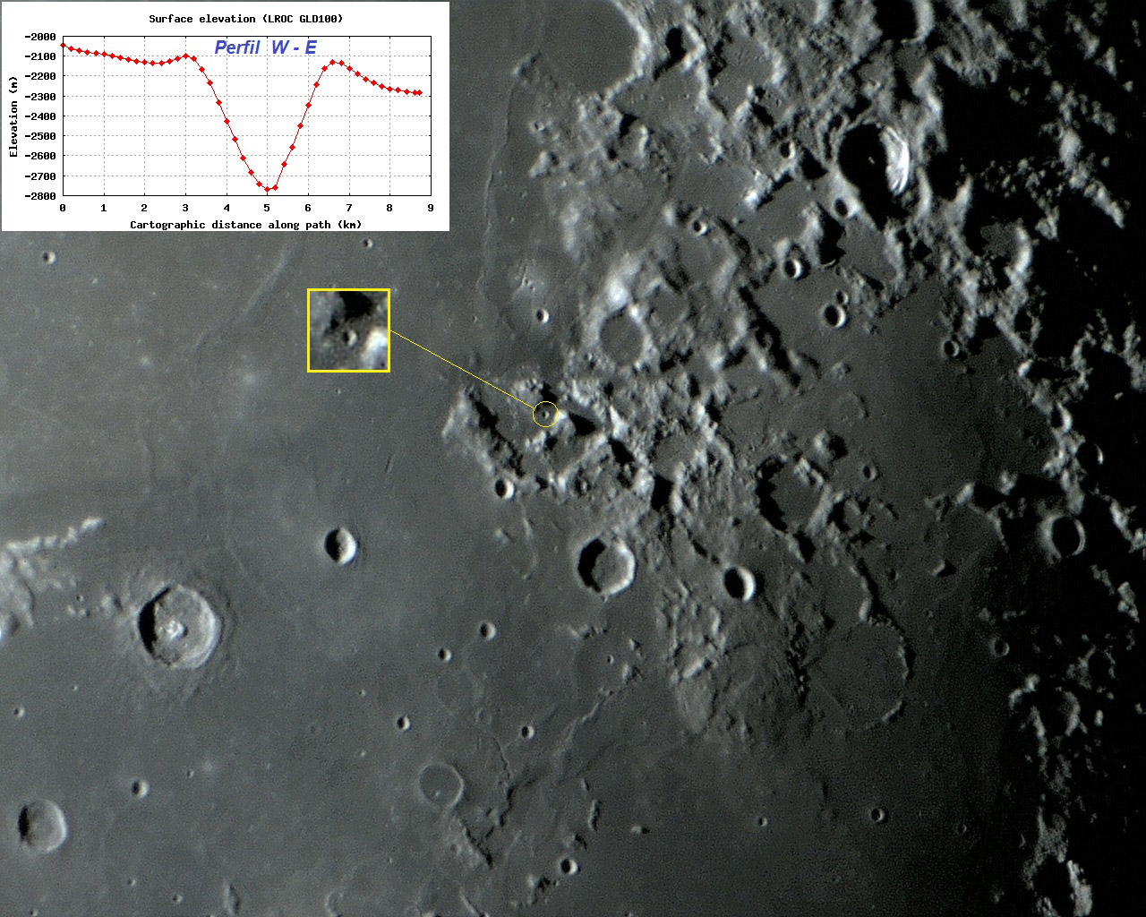
image by Ricardo Jose Vaz Tolentino, Brasil
Ching-Te is a tiny impact crater of simple morphology, which is located west of the famous Taurus Littrow Valley, which was the landing site of the last mission of the Apollo program (Apollo 17). The landing point is distant approximately 20 km from Ching-Te, so some of it's ejecta may have been sampled by Apollo 17. According to the altimetric profile of QuickMap, the crater is 3.5 km in diameter, and 670 m deep. Ching-Te is a Chinese male name that has no connection with any specific personality of history (astronomer, mathematician, philosopher, etc). Initially, Ching-Te and other informal (unofficial) names were only created to identify tiny or small features present on detailed maps of Topophotomap series, which were made by NASA, based on the images captured by the Apollo missions. For example, in the legends of the map sheet showing Ching-Te (Topophotomap 42C3S3) is written: Names Information: The following names are unofficial and used only for the identifications of features on this map: CHING-TE, PIT RUDOLPH, RIMA CARMEN and STELLA. Later, in 1976, most of the names for small features, but not all, were officially approved by the International Astronomical Union. A detailed #-D visualization of Ching-Te can be seen here. Use the "Autorotate" and "Vertical Exaggeration" functions below the image:
Ricardo Jose Vaz Tolentino
Technical details
September 13, 2014, 02:17:48 (05:17:48 UT).
Sky-Watcher Collapsible Truss-Tube DOB + Orion StarShoot Solar System Color Imager III Camera + Celestron Ultima 2X Barlow - just one frame.
Related Links
21st Century Atlas chart 8.
Ricardo's website
Yesterday's LPOD: Over the Pole and in the Hole
Tomorrow's LPOD: T-Rex Smile
COMMENTS?
Register, Log in, and join in the comments.


