Difference between revisions of "May 10, 2013"
| (4 intermediate revisions by the same user not shown) | |||
| Line 1: | Line 1: | ||
__NOTOC__ | __NOTOC__ | ||
=Rilles And More= | =Rilles And More= | ||
| + | <!-- Start of content --> | ||
<!-- ws:start:WikiTextHeadingRule:0:<h1> --> | <!-- ws:start:WikiTextHeadingRule:0:<h1> --> | ||
<!-- ws:start:WikiTextLocalImageRule:6:<img src="/file/view/LPOD-May10-13.jpg/430398178/LPOD-May10-13.jpg" alt="" title="" /> -->[[File:LPOD-May10-13.jpg|LPOD-May10-13.jpg]]<!-- ws:end:WikiTextLocalImageRule:6 --><br /> | <!-- ws:start:WikiTextLocalImageRule:6:<img src="/file/view/LPOD-May10-13.jpg/430398178/LPOD-May10-13.jpg" alt="" title="" /> -->[[File:LPOD-May10-13.jpg|LPOD-May10-13.jpg]]<!-- ws:end:WikiTextLocalImageRule:6 --><br /> | ||
<em>image by [mailto:kryptonik@mail.ru Александр Ястребов (Alexander Jastrebov)], Bryansk, Russia</em><br /> | <em>image by [mailto:kryptonik@mail.ru Александр Ястребов (Alexander Jastrebov)], Bryansk, Russia</em><br /> | ||
<br /> | <br /> | ||
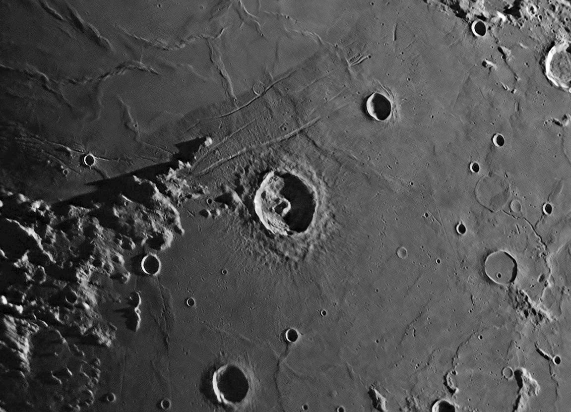
| − | Here is [http://lpod. | + | Here is [http://www2.lpod.org/wiki/March_17,_2013 another] superb image from Alexander, with the chrome-like glow of the mare that seems to be his signature. Tear yourself away from the beauty of the image to look at the geology. The boundary between the darker lavas of Tranquillitatis and ridge-crossed lighter lavas of Serenitatis is very distinct. Notice at top right that you could easily draw the boundary where the Serenitatis smooth lavas fill a low area that embays the older lavas of Tranquilitatis. Small scale volcanism is everywhere here too, from the dome cut by the Menelaus Rille (upper left) to the apparent extrusion along the rille leading up to Al-Bakri. Altimetry from the LRO QuickMap shows that the rille - which is partially a series of elongate collapse [http://target.lroc.asu.edu/da/qmap.html?mv=eqc&mcx=614431.43114&mcy=410981.94535&mz=8 depressions] and likely v-vents - is at the crest of a 200 m high ridge. You can explore many other features here at your leisure but notice how the Jansen Rille just stops when it reaches the ghost crater. The rille starts at a depression on the mare ridge and flows downhill until it meets the ghost crater which is about 50-60 m high. Does the rille get stooped by the ghost rim or did the rille continue and the rim get created later, covering the rille? QuickMap [http://target.lroc.asu.edu/da/qmap.html?mv=eqc&mcx=873723.77845&mcy=447805.50898&mz=9 shows] that a much smaller piece of the rille seems to have climbed the edge of the ghost rim but there is no NAC image of that contact. It seems unlikely that the ghost buried the rille, but if the ghost rim was just an obstacle why didn't the rille bend to go along its edge as commonly happens?<br /> |
<br /> | <br /> | ||
<em>[mailto:tychocrater@yahoo.com Chuck Wood]</em><br /> | <em>[mailto:tychocrater@yahoo.com Chuck Wood]</em><br /> | ||
| Line 13: | Line 14: | ||
<br /> | <br /> | ||
<strong>Related Links</strong><br /> | <strong>Related Links</strong><br /> | ||
| − | Rükl plate [ | + | Rükl plate [https://the-moon.us/wiki/R%C3%BCkl_35 35]<br /> |
| − | <em>[ | + | <em>[[21st Century Atlas of the Moon|21st Century Atlas]]</em> chart 8.<br /> |
<br /> | <br /> | ||
<p><b>Yesterday's LPOD:</b> [[May 9, 2013|Positive About Negative]] </p> | <p><b>Yesterday's LPOD:</b> [[May 9, 2013|Positive About Negative]] </p> | ||
<p><b>Tomorrow's LPOD:</b> [[May 11, 2013|Moon Rise with Little Oxygen]] </p> | <p><b>Tomorrow's LPOD:</b> [[May 11, 2013|Moon Rise with Little Oxygen]] </p> | ||
<hr /> | <hr /> | ||
| + | {{wiki/ArticleFooter}} | ||
Latest revision as of 07:32, 28 October 2018
Rilles And More

image by Александр Ястребов (Alexander Jastrebov), Bryansk, Russia
Here is another superb image from Alexander, with the chrome-like glow of the mare that seems to be his signature. Tear yourself away from the beauty of the image to look at the geology. The boundary between the darker lavas of Tranquillitatis and ridge-crossed lighter lavas of Serenitatis is very distinct. Notice at top right that you could easily draw the boundary where the Serenitatis smooth lavas fill a low area that embays the older lavas of Tranquilitatis. Small scale volcanism is everywhere here too, from the dome cut by the Menelaus Rille (upper left) to the apparent extrusion along the rille leading up to Al-Bakri. Altimetry from the LRO QuickMap shows that the rille - which is partially a series of elongate collapse depressions and likely v-vents - is at the crest of a 200 m high ridge. You can explore many other features here at your leisure but notice how the Jansen Rille just stops when it reaches the ghost crater. The rille starts at a depression on the mare ridge and flows downhill until it meets the ghost crater which is about 50-60 m high. Does the rille get stooped by the ghost rim or did the rille continue and the rim get created later, covering the rille? QuickMap shows that a much smaller piece of the rille seems to have climbed the edge of the ghost rim but there is no NAC image of that contact. It seems unlikely that the ghost buried the rille, but if the ghost rim was just an obstacle why didn't the rille bend to go along its edge as commonly happens?
Chuck Wood
Technical Details
Apr 16, 2013. 40cm telescope, Basler asA640-100gm, IR-pass filter.
Related Links
Rükl plate 35
21st Century Atlas chart 8.
Yesterday's LPOD: Positive About Negative
Tomorrow's LPOD: Moon Rise with Little Oxygen
COMMENTS?
Register, Log in, and join in the comments.


