Difference between revisions of "February 6, 2013"
| (7 intermediate revisions by the same user not shown) | |||
| Line 1: | Line 1: | ||
__NOTOC__ | __NOTOC__ | ||
=Near Polar Rubble= | =Near Polar Rubble= | ||
| + | <!-- Start of content --> | ||
<!-- ws:start:WikiTextHeadingRule:0:<h1> --> | <!-- ws:start:WikiTextHeadingRule:0:<h1> --> | ||
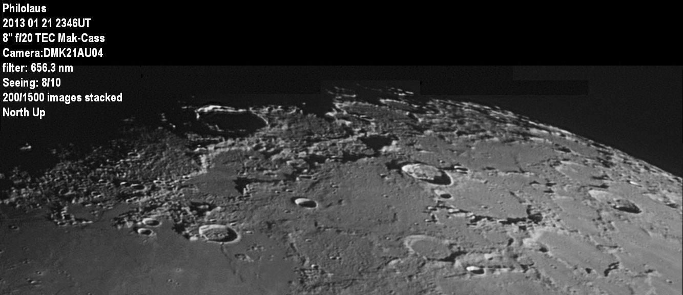
<!-- ws:start:WikiTextLocalImageRule:6:<img src="/file/view/LPOD-Feb6-13.jpg/404701592/LPOD-Feb6-13.jpg" alt="" title="" /> -->[[File:LPOD-Feb6-13.jpg|LPOD-Feb6-13.jpg]]<!-- ws:end:WikiTextLocalImageRule:6 --><br /> | <!-- ws:start:WikiTextLocalImageRule:6:<img src="/file/view/LPOD-Feb6-13.jpg/404701592/LPOD-Feb6-13.jpg" alt="" title="" /> -->[[File:LPOD-Feb6-13.jpg|LPOD-Feb6-13.jpg]]<!-- ws:end:WikiTextLocalImageRule:6 --><br /> | ||
| − | <em>image by [mailto:rhill@lpl.arizona.edu | + | <em>image by [mailto:rhill@lpl.arizona.edu Rik Hill], Loudon Observatory, Tucson, Arizona</em><br /> |
<br /> | <br /> | ||
| − | This image is dominated by the shadow filled ring of Philolaus. I like the region just to the south from Fontenelle to Timaeus, particularly inside Birmingham. | + | This image is dominated by the shadow filled ring of Philolaus. I like the region just to the south from Fontenelle to Timaeus, particularly inside Birmingham. |
| − | I'm surprised this "crater" actually got a name of its own yet Philolaus B did not get its own name and is much more identifiable. But the hummocky terrain in | + | I'm surprised this "crater" actually got a name of its own yet Philolaus B did not get its own name and is much more identifiable. But the hummocky terrain in |
| − | the bottom of Birmingham is more reminiscent of the kind of landform you'd see in the ejecta blanket of a larger crater. Is the ejecta from Plato? Also | + | the bottom of Birmingham is more reminiscent of the kind of landform you'd see in the ejecta blanket of a larger crater. Is the ejecta from Plato? Also interesting is the "wrinkle ridge" that runs south from the crater Fontenelle. The portion near Fontenelle seems to form one wall, and the southern wall of Birmingham |
| − | + | the other of an ancient crater now buried. This libration was fairly favorable for this region with the point of maximum libration just to the right of this image. | |
| − | the other of an ancient crater now buried. This libration was fairly favorable for this region with the point of maximum libration just to the right of this image. | + | As a result, at the far right we can easily see Byrd, Peary and Nansen as well as the figure-8 pair of Challis and Main. |
| − | As a result, at the far right we can easily see Byrd, Peary and Nansen as well as the figure-8 pair of Challis and Main. | ||
<br /> | <br /> | ||
| − | <em>[mailto:rhill@lpl.arizona.edu | + | <br /> |
| + | <em>[mailto:rhill@lpl.arizona.edu Rik Hill]</em><br /> | ||
<em><strong>Note from CAW:</strong> Birmingham's bumpy floor is probably Imbrium ejecta.</em><br /> | <em><strong>Note from CAW:</strong> Birmingham's bumpy floor is probably Imbrium ejecta.</em><br /> | ||
<br /> | <br /> | ||
| Line 19: | Line 20: | ||
<br /> | <br /> | ||
<strong>Related Links</strong><br /> | <strong>Related Links</strong><br /> | ||
| − | Rükl plate [ | + | Rükl plate [https://the-moon.us/wiki/R%C3%BCkl_3 3]<br /> |
| − | <em>[ | + | <em>[[21st Century Atlas of the Moon|21st Century Atlas]]</em> chart 19.<br /> |
<br /> | <br /> | ||
| + | <p><b>Yesterday's LPOD:</b> [[February 5, 2013|Plumy Ash]] </p> | ||
| + | <p><b>Tomorrow's LPOD:</b> [[February 7, 2013|Albumen Moon]] </p> | ||
<hr /> | <hr /> | ||
| + | {{wiki/ArticleFooter}} | ||
Latest revision as of 07:27, 28 October 2018
Near Polar Rubble

image by Rik Hill, Loudon Observatory, Tucson, Arizona
This image is dominated by the shadow filled ring of Philolaus. I like the region just to the south from Fontenelle to Timaeus, particularly inside Birmingham.
I'm surprised this "crater" actually got a name of its own yet Philolaus B did not get its own name and is much more identifiable. But the hummocky terrain in
the bottom of Birmingham is more reminiscent of the kind of landform you'd see in the ejecta blanket of a larger crater. Is the ejecta from Plato? Also interesting is the "wrinkle ridge" that runs south from the crater Fontenelle. The portion near Fontenelle seems to form one wall, and the southern wall of Birmingham
the other of an ancient crater now buried. This libration was fairly favorable for this region with the point of maximum libration just to the right of this image.
As a result, at the far right we can easily see Byrd, Peary and Nansen as well as the figure-8 pair of Challis and Main.
Rik Hill
Note from CAW: Birmingham's bumpy floor is probably Imbrium ejecta.
Technical Details
Registax6, and further processing done with IrfanView, GIMP and montage assembly with AutoStitch.
Related Links
Rükl plate 3
21st Century Atlas chart 19.
Yesterday's LPOD: Plumy Ash
Tomorrow's LPOD: Albumen Moon
COMMENTS?
Register, Log in, and join in the comments.


