Difference between revisions of "February 13, 2011"
(Created page with "__NOTOC__ =A Thick Problem= <!-- ws:start:WikiTextHeadingRule:0:<h1> --> <!-- ws:start:WikiTextLocalImageRule:6:<img src="/file/view/LPOD-Feb13-11.jpg/201076...") |
|||
| (7 intermediate revisions by one other user not shown) | |||
| Line 1: | Line 1: | ||
__NOTOC__ | __NOTOC__ | ||
=A Thick Problem= | =A Thick Problem= | ||
| − | + | <!-- Start of content --> | |
| − | + | <!-- ws:start:WikiTextHeadingRule:0:<h1> --> | |
| − | + | <!-- ws:start:WikiTextLocalImageRule:6:<img src="/file/view/LPOD-Feb13-11.jpg/201076296/LPOD-Feb13-11.jpg" alt="" title="" /> -->[[File:LPOD-Feb13-11.jpg|LPOD-Feb13-11.jpg]]<!-- ws:end:WikiTextLocalImageRule:6 --><br /> | |
<em>looking south LRO crustal thickness</em> <em>image processed by [mailto:mauricejscollins@hotmail.com Maurice Collins]</em><br /> | <em>looking south LRO crustal thickness</em> <em>image processed by [mailto:mauricejscollins@hotmail.com Maurice Collins]</em><br /> | ||
<br /> | <br /> | ||
| − | A day or so ago Maurice posted a global crustal thickness [ | + | A day or so ago Maurice posted a global crustal thickness map to see if there was thinning under the putative Timoris Basin |
| + | - there isn't and the basin probably never existed. But he noticed a strangeness at Mare Tranquilitatis and made this oblique | ||
| + | view image to understand it better. Tranquillitatis is weird because it is roughly round and is filled with lava - two characteristics | ||
| + | of impact basins. Except topo maps show that the eastern side of the basin (left) is relatively high, and there is little obvious | ||
| + | basin structure. And this crustal thickness map - blue is thin crust, purple is thinner and shades of green are thicker - mimics | ||
| + | the topography. The western arc of the mare has a thin crust, with greatest thinning at Lamont - maybe it [[May_13,_2010|really]] is a buried small | ||
| + | basin. The center and eastern parts of Tranquillitatis have thicknesses similar to some highlands areas - apparently there never | ||
| + | was a basin there. And yet these parts are slightly low, and mare lavas - from the volcanic dome vents near the Cauchy Fault? - | ||
| + | covered it. Our simple models of a crust that Is thinned, and elevations that are lowered, only by basin impacts may leave out | ||
| + | other processes that we haven't yet discovered. | ||
<br /> | <br /> | ||
| + | <br /> | ||
| + | <em>[mailto:tychocrater@yahoo.com Chuck Wood]</em><br /> | ||
| + | <br /> | ||
| + | <p><b>Yesterday's LPOD:</b> [[February 12, 2011|Egyptian Moon]] </p> | ||
| + | <p><b>Tomorrow's LPOD:</b> [[February 14, 2011|Valentine Moon]] </p> | ||
<hr /> | <hr /> | ||
| − | + | {{wiki/ArticleFooter}} | |
| − | |||
| − | |||
| − | |||
Latest revision as of 19:48, 27 October 2018
A Thick Problem

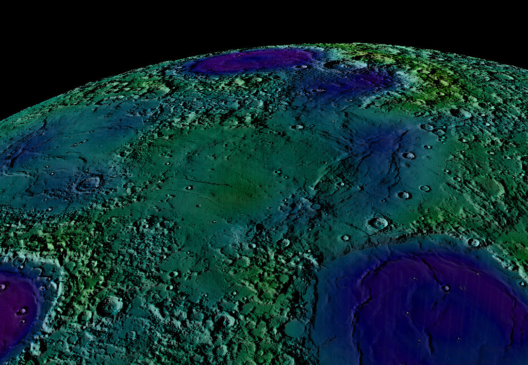
looking south LRO crustal thickness image processed by Maurice Collins
A day or so ago Maurice posted a global crustal thickness map to see if there was thinning under the putative Timoris Basin
- there isn't and the basin probably never existed. But he noticed a strangeness at Mare Tranquilitatis and made this oblique
view image to understand it better. Tranquillitatis is weird because it is roughly round and is filled with lava - two characteristics
of impact basins. Except topo maps show that the eastern side of the basin (left) is relatively high, and there is little obvious
basin structure. And this crustal thickness map - blue is thin crust, purple is thinner and shades of green are thicker - mimics
the topography. The western arc of the mare has a thin crust, with greatest thinning at Lamont - maybe it really is a buried small
basin. The center and eastern parts of Tranquillitatis have thicknesses similar to some highlands areas - apparently there never
was a basin there. And yet these parts are slightly low, and mare lavas - from the volcanic dome vents near the Cauchy Fault? -
covered it. Our simple models of a crust that Is thinned, and elevations that are lowered, only by basin impacts may leave out
other processes that we haven't yet discovered.
Chuck Wood
Yesterday's LPOD: Egyptian Moon
Tomorrow's LPOD: Valentine Moon
COMMENTS?
Register, Log in, and join in the comments.


