|
|
| (7 intermediate revisions by the same user not shown) |
| Line 1: |
Line 1: |
| | __NOTOC__ | | __NOTOC__ |
| | =A Hidden Plateau= | | =A Hidden Plateau= |
| | + | <!-- Start of content --> |
| | <div class="post" id="post-1260"> | | <div class="post" id="post-1260"> |
| | | | |
| Line 6: |
Line 7: |
| | <p>[[File:GutenbergRillesLPOD.jpg|GutenbergRillesLPOD.jpg]]<br /> | | <p>[[File:GutenbergRillesLPOD.jpg|GutenbergRillesLPOD.jpg]]<br /> |
| | <em>image by [mailto:s_fire@online.ua Павел Пресняков (Pavel Presnyakov)], Kiev Ukraine</em></p> | | <em>image by [mailto:s_fire@online.ua Павел Пресняков (Pavel Presnyakov)], Kiev Ukraine</em></p> |
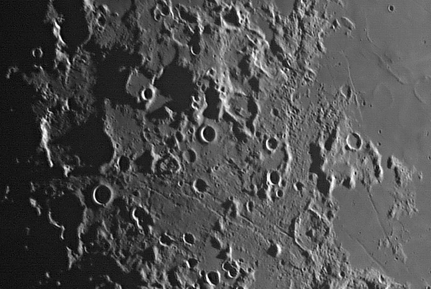
| − | <p>I have committed sacrilege. I have cropped out about half of Pavel’s wonderful mosaic (leaving out Messier, Gutenberg and other craters). The reason for my transgression was the desire to show at full resolution an area chock full of interesting features, rather than a larger area at sub-resolution. This region, nameless but for my [http://www.lpod.org/archive/LPOD-2004-09-19.htm resurrection] of Hevelius’ designation <em>Colchis </em>has only a few named features - the Gutenberg and Goclenius rilles, the small crater Leakey, and Lubbock. I am captivated by some of the usually less conspicuous features, that because of low lighting and high resolution here, show up dramatically. The prime example is the highland plateau at the top center of the image. Based on its distance from the center of the Nectaris Basin, this is probably the northern [http://www.lpod.org/?m=20061210 continuation] of the main basin rim marked to the southwest by the Altai Scarp. The large, shadow-filled bite out of the plateau is the crater Censorinus N, and just to it’s west is an unnamed ruined crater whose floor of relatively smooth fill is like a garden suspended over the lowlands to the south and west. Another interesting feature is the broad valley on the east side of the image, stretching from Gutenberg G (bottom right with central peak surrounded by ejecta) up past Lubbock. The floor of this valley contains small hills that appear to be lineated parallel to the edges. Is this a surface flow of ejecta from the formation of the Nectaris Basin?</p> | + | <p>I have committed sacrilege. I have cropped out about half of Pavel’s wonderful mosaic (leaving out Messier, Gutenberg and other craters). The reason for my transgression was the desire to show at full resolution an area chock full of interesting features, rather than a larger area at sub-resolution. This region, nameless but for my [[September_19,_2004|resurrection]] of Hevelius’ designation <em>Colchis </em>has only a few named features - the Gutenberg and Goclenius rilles, the small crater Leakey, and Lubbock. I am captivated by some of the usually less conspicuous features, that because of low lighting and high resolution here, show up dramatically. The prime example is the highland plateau at the top center of the image. Based on its distance from the center of the Nectaris Basin, this is probably the northern [[December_10,_2006|continuation]] of the main basin rim marked to the southwest by the Altai Scarp. The large, shadow-filled bite out of the plateau is the crater Censorinus N, and just to it’s west is an unnamed ruined crater whose floor of relatively smooth fill is like a garden suspended over the lowlands to the south and west. Another interesting feature is the broad valley on the east side of the image, stretching from Gutenberg G (bottom right with central peak surrounded by ejecta) up past Lubbock. The floor of this valley contains small hills that appear to be lineated parallel to the edges. Is this a surface flow of ejecta from the formation of the Nectaris Basin?</p> |
| | <p>[mailto:tychocrater@yahoo.com Chuck Wood]</p> | | <p>[mailto:tychocrater@yahoo.com Chuck Wood]</p> |
| | <p><strong>Technical Details:</strong><br /> | | <p><strong>Technical Details:</strong><br /> |
| Line 12: |
Line 13: |
| | <p><strong>Related Links:</strong><br /> | | <p><strong>Related Links:</strong><br /> |
| | [http://www.astroclub.kiev.ua/gallery/search.php?search_user=S.Fire Pavel’s website]<br /> | | [http://www.astroclub.kiev.ua/gallery/search.php?search_user=S.Fire Pavel’s website]<br /> |
| − | [http://www.lpod.org/?m=20061005 A higher Sun view]</p> | + | [[October_5,_2006|A higher Sun view]]</p> |
| − | <div align="center"><em>LPOD earns a commission when you buy ANY book from Amazon thru </em><em>[[LPOD]]<br /> | + | <p><b>Yesterday's LPOD:</b> [[July 19, 2007|An Oblique View of Prom Laplace]] </p> |
| − | </em></div> | + | <p><b>Tomorrow's LPOD:</b> [[July 21, 2007|Lunar People]] </p> |
| | </div> | | </div> |
| − | ---- | + | <p> </p> |
| − | ===COMMENTS?===
| + | <p> </p> |
| − | Click on this icon [[image:PostIcon.jpg]] at the upper right to post a comment.
| + | <p> </p> |
| | + | <!-- End of content --> |
| | + | {{wiki/ArticleFooter}} |


