Difference between revisions of "February 26, 2011"
| Line 1: | Line 1: | ||
__NOTOC__ | __NOTOC__ | ||
=Colorful Micro-Topo= | =Colorful Micro-Topo= | ||
| + | <!-- Start of content --> | ||
<!-- ws:start:WikiTextHeadingRule:0:<h1> --> | <!-- ws:start:WikiTextHeadingRule:0:<h1> --> | ||
<!-- ws:start:WikiTextLocalImageRule:6:<img src="/file/view/LPOD-Feb26-11.jpg/205177462/LPOD-Feb26-11.jpg" alt="" title="" /> -->[[File:LPOD-Feb26-11.jpg|LPOD-Feb26-11.jpg]]<!-- ws:end:WikiTextLocalImageRule:6 --><br /> | <!-- ws:start:WikiTextLocalImageRule:6:<img src="/file/view/LPOD-Feb26-11.jpg/205177462/LPOD-Feb26-11.jpg" alt="" title="" /> -->[[File:LPOD-Feb26-11.jpg|LPOD-Feb26-11.jpg]]<!-- ws:end:WikiTextLocalImageRule:6 --><br /> | ||
| Line 15: | Line 16: | ||
<p><b>Tomorrow's LPOD:</b> [[February 27, 2011|Nectaris Rilles]] </p> | <p><b>Tomorrow's LPOD:</b> [[February 27, 2011|Nectaris Rilles]] </p> | ||
<hr /> | <hr /> | ||
| + | {{wiki/ArticleFooter}} | ||
Revision as of 13:32, 8 February 2015
Colorful Micro-Topo

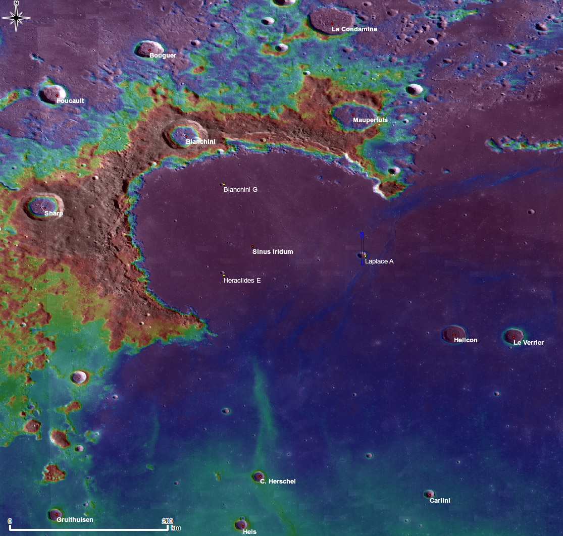
image from LRO Featured Image (NASA/GSFC/Arizona State University).
I read somewhere recently that the LOLA altimeter on LRO has acquired more than 6 billion measurements of the lunar surface. That number - or whatever the actual one is - is so enormous that it will be possible to generate topographic images that show small scale topography. But there is a second way to also produce a high density of elevation measurements, an old-fashioned way. German Aerospace Center scientists use overlapping LRO Wide Angle Camera images to generate stereo models of topography. It used to be that analysts would individually match thousands of points in stereo images and use the offset due to the two perspectives to calculate elevations. Now computers automatically do the mind-numbing matching, working faster and building larger digital elevation models (DEM). On this image map the tendrils of blue in front of Sinus Iridum aren't crater rays, but low mare ridges. No color bar was included with this image to show the elevations associated with each color, but the ridges are probably less than 100 m high. With the LOLA altimeter continuing to collect measurements and the German stereo machines keep operating we will soon have two independent high resolution topographic maps of the Moon. About time.
Chuck Wood//
Related Links
Rükl plate 10
Yesterday's LPOD: Back To the Drawing Board
Tomorrow's LPOD: Nectaris Rilles
COMMENTS?
Register, Log in, and join in the comments.


