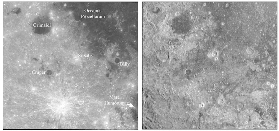
image by B.A. Campbell and B. Ray Hawke………… CAUTION: Wide image - stretch window to the max!
Radar is magical. The beams of energy from the Arecibo and Greenbank radio telescopes that get pulsed to the Moon penetrate the surface materials for distances comparable to many multiples of their wavelength. Bruce Campbell of the Smithsonian Institution and B. Ray Hawke of the University of Hawaii, who have been mapping the Moon with 70 cm wavelengths, have discovered unexpected surprises a few tens of meters below the visible surface. Most spectacular is this image showing large tracts of mare basalt underlying the Orientale basin ejecta. The western shore of Oceanus Procellarum between Grimaldi and Billy is ill-defined. Now we know why – the mare lavas are covered by Orientale ejecta, and the boundary is where the ejecta thinned out to nothingness. The image on the left – from Clementine – shows the normal visible light view, and the right image is what radar reveals. Note that mare material is dark on radar because it is smooth and doesn’t reflect much energy back. Look on the Clementine at how the shore of Procellarum curves to the southeast from Grimaldi to Billy to north of Humorum. That shore is invisible on the radar image – if we could excavate down a few tens of meters we would find the continuation of Procellarum lavas far to the west of their present extent. So when you next look at Crüger – another dark-floored crater like Billy – realize that it sits on mare basalts. And further west where the low radar reflections stop doesn’t necessarily mean that there is no more buried mare. It may be simply where the Orientale ejecta is too thick for the radar to penetrate. I wonder how extensive this biggest ocean of lava on the Moon really was/is?
Technical Details:
70 cm radar data collected with Arecibo and Greenbank telescopes – the best resolution is about 400 m near the limbs and 900 m near the center of face.
Related Links:
Rükl charts 39 & 50
Cryptomare deposits revealed by 70-cm radar
Yesterday's LPOD: Elger Reborn?
Tomorrow's LPOD: Still Mysterious After All These Years
COMMENTS?
Register, Log in, and join in the comments.


