Difference between revisions of "January 23, 2006"

From LPOD
Jump to: navigation, search
(Created page with "__NOTOC__ =Name That Basin Rim!= <div class="post" id="post-27"> <div class="storycontent"> <p>S.POLE-AITKEN basin rim-Apollo8<br /> <...")
 
 
(6 intermediate revisions by the same user not shown)
Line 1: Line 1:
 
__NOTOC__
 
__NOTOC__
 
=Name That Basin Rim!=
 
=Name That Basin Rim!=
 +
<!-- Start of content -->
 +
<div class="post" id="post-27">
  
+
<div class="storycontent">
<div class="post" id="post-27">
+
<p>[[File:As08-13-2319BBBENH.jpg|S.POLE-AITKEN basin rim-Apollo8]]<br />
 
<div class="storycontent">
 
<p>[[File:as08-13-2319BBBENH.jpg|S.POLE-AITKEN basin rim-Apollo8]]<br />
 
 
<em>Apollo 8 image AS08-13-2319 via[http://www.lpi.usra.edu/resources/apollo/  Lunar &#038; Planetary Institute ]</em></p>
 
<em>Apollo 8 image AS08-13-2319 via[http://www.lpi.usra.edu/resources/apollo/  Lunar &#038; Planetary Institute ]</em></p>
 
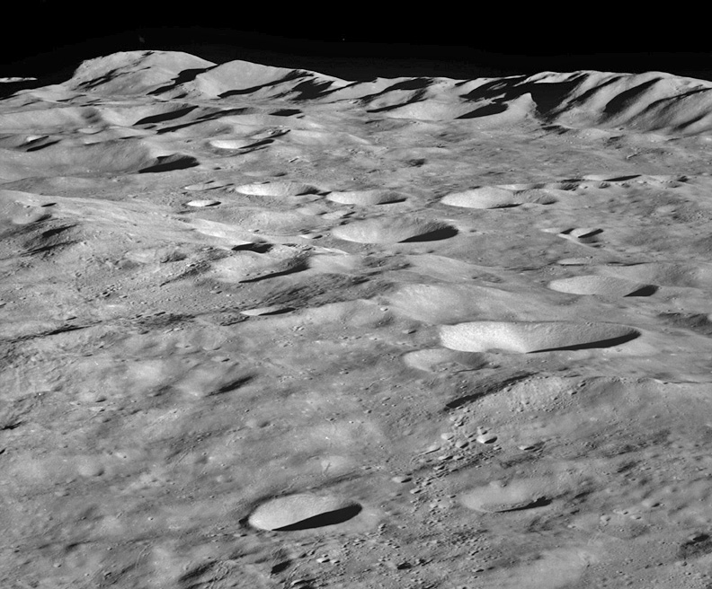
<p>Looking obliquely, one of the Apollo 8 crew (Borman, Lovell or Anders) shot a few frames of a magnificent lunar mountain range. None of the foreground craters is easily recognizable and the mountain range itself does not look like the craggy scarp of the Apennines or the shear fault of the Altai. What and where is it? Some of the photos immediately before and after this image are of recognizable farside craters allowing us to identify this range as part of the northern rim of the 2500 km wide South Pole-Aitken (SPA) impact basin. I don’t know the exact coordinates of this view but it is somewhere between the basins Apollo and Korolev – can you find out where it is exactly? According to Clementine altimetry data the SPA basin rim is only 1.8 km high, but this looks taller than that. There may be another lower and more degraded basin ring arcing through the center of the image from upper left to lower right. I also expect that there is a young impact crater off the image to the bottom that is the source for the cluster of secondary craters near the bottom right. </p>
 
<p>Looking obliquely, one of the Apollo 8 crew (Borman, Lovell or Anders) shot a few frames of a magnificent lunar mountain range. None of the foreground craters is easily recognizable and the mountain range itself does not look like the craggy scarp of the Apennines or the shear fault of the Altai. What and where is it? Some of the photos immediately before and after this image are of recognizable farside craters allowing us to identify this range as part of the northern rim of the 2500 km wide South Pole-Aitken (SPA) impact basin. I don’t know the exact coordinates of this view but it is somewhere between the basins Apollo and Korolev – can you find out where it is exactly? According to Clementine altimetry data the SPA basin rim is only 1.8 km high, but this looks taller than that. There may be another lower and more degraded basin ring arcing through the center of the image from upper left to lower right. I also expect that there is a young impact crater off the image to the bottom that is the source for the cluster of secondary craters near the bottom right. </p>
Line 13: Line 12:
 
Late January 1968, Hasselblad 500 EL cameras with 250-millimeter Zeiss panacolor lens.<br />
 
Late January 1968, Hasselblad 500 EL cameras with 250-millimeter Zeiss panacolor lens.<br />
 
<strong>Related Links:</strong><br />
 
<strong>Related Links:</strong><br />
<a href=http://www.lpi.usra.edu/expmoon/Apollo8/Apollo8.html>Apollo 8 Mission</a><br />
+
[http://www.lpi.usra.edu/expmoon/Apollo8/Apollo8.html Apollo 8 Mission]<br />
 
Rükl chart page 191</p>
 
Rükl chart page 191</p>
</div>
+
<p><b>Yesterday's LPOD:</b> [[January 22, 2006|A Corner of Decay]] </p>
+
<p><b>Tomorrow's LPOD:</b> [[January 24, 2006|Fecund Questions]] </p>
 
+
</div>
----
+
<!-- End of content -->
===COMMENTS?===
+
{{wiki/ArticleFooter}}
Click on this icon [[image:PostIcon.jpg]] at the upper right to post a comment.
 

Latest revision as of 19:23, 7 February 2015

Name That Basin Rim!

S.POLE-AITKEN basin rim-Apollo8
Apollo 8 image AS08-13-2319 viaLunar & Planetary Institute

Looking obliquely, one of the Apollo 8 crew (Borman, Lovell or Anders) shot a few frames of a magnificent lunar mountain range. None of the foreground craters is easily recognizable and the mountain range itself does not look like the craggy scarp of the Apennines or the shear fault of the Altai. What and where is it? Some of the photos immediately before and after this image are of recognizable farside craters allowing us to identify this range as part of the northern rim of the 2500 km wide South Pole-Aitken (SPA) impact basin. I don’t know the exact coordinates of this view but it is somewhere between the basins Apollo and Korolev – can you find out where it is exactly? According to Clementine altimetry data the SPA basin rim is only 1.8 km high, but this looks taller than that. There may be another lower and more degraded basin ring arcing through the center of the image from upper left to lower right. I also expect that there is a young impact crater off the image to the bottom that is the source for the cluster of secondary craters near the bottom right.

Chuck Wood

Technical Details:
Late January 1968, Hasselblad 500 EL cameras with 250-millimeter Zeiss panacolor lens.
Related Links:
Apollo 8 Mission
Rükl chart page 191

Yesterday's LPOD: A Corner of Decay

Tomorrow's LPOD: Fecund Questions


COMMENTS?

Register, Log in, and join in the comments.