Difference between revisions of "November 28, 2012"
| Line 3: | Line 3: | ||
<!-- ws:start:WikiTextHeadingRule:0:<h1> --> | <!-- ws:start:WikiTextHeadingRule:0:<h1> --> | ||
<!-- ws:start:WikiTextLocalImageRule:6:<img src="/file/view/LPOD-Nov28-12.jpg/386730982/LPOD-Nov28-12.jpg" alt="" title="" /> -->[[File:LPOD-Nov28-12.jpg|LPOD-Nov28-12.jpg]]<!-- ws:end:WikiTextLocalImageRule:6 --><br /> | <!-- ws:start:WikiTextLocalImageRule:6:<img src="/file/view/LPOD-Nov28-12.jpg/386730982/LPOD-Nov28-12.jpg" alt="" title="" /> -->[[File:LPOD-Nov28-12.jpg|LPOD-Nov28-12.jpg]]<!-- ws:end:WikiTextLocalImageRule:6 --><br /> | ||
| − | <em>image by [mailto:luccat@sfr.fr | + | <em>image by [mailto:luccat@sfr.fr Luc CATHALA], Mazan 84380 France</em><br /> |
<br /> | <br /> | ||
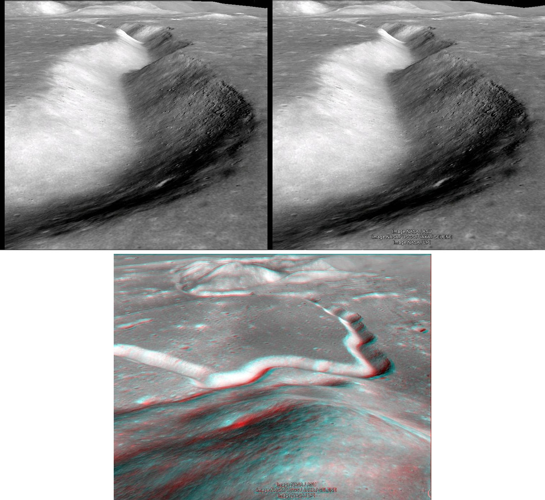
| − | Because of the bad weather in France can not image the Moon, so I do 3D pictures. Today I bring you to the edge of Rima Hadley in 3D thanks to the Google Earth software option Moon. The elevation data used allow you to easily do images in 3D. The best results are obtained by using the areas high resolutions. You have the version squinted and the version anaglyphs made with the software [http://stereo.jpn.org/eng/index.html | + | Because of the bad weather in France can not image the Moon, so I do 3D pictures. Today I bring you to the edge of Rima Hadley in 3D thanks to the Google Earth software option Moon. The elevation data used allow you to easily do images in 3D. The best results are obtained by using the areas high resolutions. You have the version squinted and the version anaglyphs made with the software [http://stereo.jpn.org/eng/index.html Stereo Photo Maker]. Excuse my English, translation was made with internet.<br /> |
<br /> | <br /> | ||
| − | <em>[mailto:luccat@sfr.fr | + | <em>[mailto:luccat@sfr.fr Luc CATHALA]</em><br /> |
<br /> | <br /> | ||
<strong>Related Links</strong><br /> | <strong>Related Links</strong><br /> | ||
Revision as of 16:57, 11 January 2015
Don't Fall In

image by Luc CATHALA, Mazan 84380 France
Because of the bad weather in France can not image the Moon, so I do 3D pictures. Today I bring you to the edge of Rima Hadley in 3D thanks to the Google Earth software option Moon. The elevation data used allow you to easily do images in 3D. The best results are obtained by using the areas high resolutions. You have the version squinted and the version anaglyphs made with the software Stereo Photo Maker. Excuse my English, translation was made with internet.
Luc CATHALA
Related Links
Rükl plate 22
21st Century Atlas chart 11.


