Difference between revisions of "May 11, 2012"
| Line 3: | Line 3: | ||
<!-- ws:start:WikiTextHeadingRule:0:<h1> --> | <!-- ws:start:WikiTextHeadingRule:0:<h1> --> | ||
<!-- ws:start:WikiTextLocalImageRule:6:<img src="http://lpod.wikispaces.com/file/view/LPOD-May11-12.jpg/333282138/LPOD-May11-12.jpg" alt="" title="" /> -->[[File:LPOD-May11-12.jpg|LPOD-May11-12.jpg]]<!-- ws:end:WikiTextLocalImageRule:6 --><br /> | <!-- ws:start:WikiTextLocalImageRule:6:<img src="http://lpod.wikispaces.com/file/view/LPOD-May11-12.jpg/333282138/LPOD-May11-12.jpg" alt="" title="" /> -->[[File:LPOD-May11-12.jpg|LPOD-May11-12.jpg]]<!-- ws:end:WikiTextLocalImageRule:6 --><br /> | ||
| − | <em>image by [mailto:raffaele.barzacchi@gmail.com | + | <em>image by [mailto:raffaele.barzacchi@gmail.com Raffaele Barzacchi]</em><br /> |
<br /> | <br /> | ||
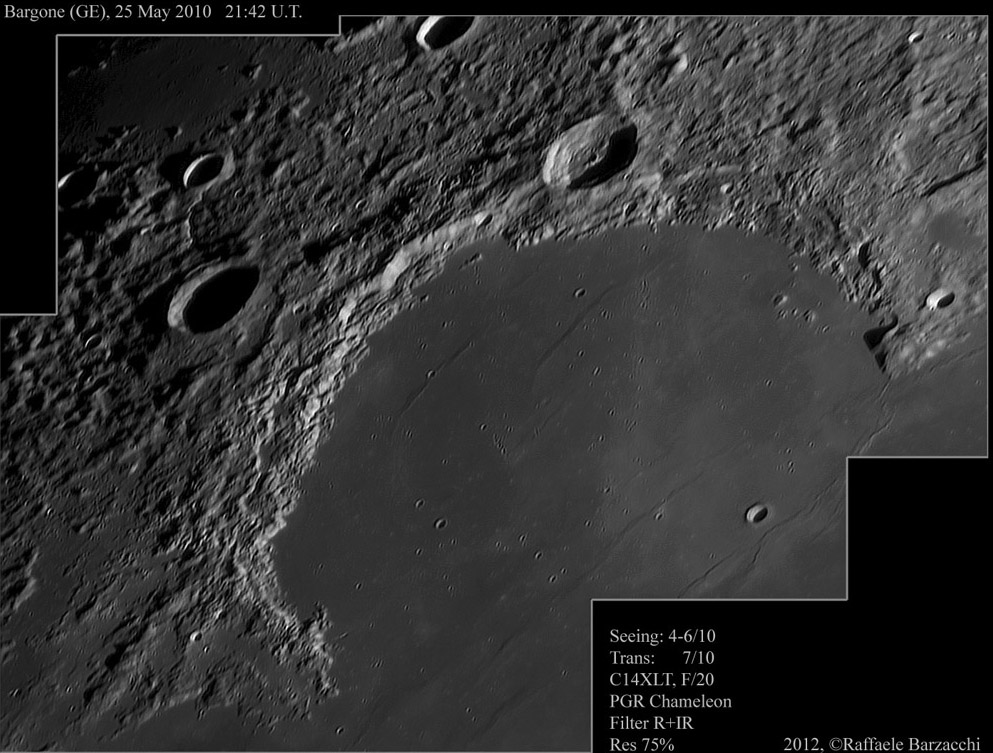
| − | LPOD has featured a number of great images of Sinus Iridum, most recently last month. The most noticeable features when the lighting is low are the parallel mare ridges that look live waves rolling in toward the shore. Certainly the mare was fluid and did flow, but mare ridges are believed to have formed after the lavas cooled and became brittle; they aren't frozen waves. The only mare ridges that are well explained are circular ones inside impact basins. These are low angle faults caused by the settling of the central slab of lava into a smaller volume as the basin subsided. It is not clear that these mare ridges in Iridum formed the same way. The ridge that passes the crater near the top of Iridum has terrain that is abruptly 120 m lower on the north side. The second ridge to the left also has lower terrain, but only 20-30 m - to the north. Are these ridges faults that are somehow associated with the lower terrain to the north? Perhaps with the aid of detailed topography from the LRO [http://target.lroc.asu.edu/da/qmap.html?mv=eqc&mcx=-937656.15269&mcy=1381752.56362&mz=6 | + | LPOD has featured a number of great images of Sinus Iridum, most recently last month. The most noticeable features when the lighting is low are the parallel mare ridges that look live waves rolling in toward the shore. Certainly the mare was fluid and did flow, but mare ridges are believed to have formed after the lavas cooled and became brittle; they aren't frozen waves. The only mare ridges that are well explained are circular ones inside impact basins. These are low angle faults caused by the settling of the central slab of lava into a smaller volume as the basin subsided. It is not clear that these mare ridges in Iridum formed the same way. The ridge that passes the crater near the top of Iridum has terrain that is abruptly 120 m lower on the north side. The second ridge to the left also has lower terrain, but only 20-30 m - to the north. Are these ridges faults that are somehow associated with the lower terrain to the north? Perhaps with the aid of detailed topography from the LRO [http://target.lroc.asu.edu/da/qmap.html?mv=eqc&mcx=-937656.15269&mcy=1381752.56362&mz=6 Quick Map] a structural geologist could examine mare ridges that aren't part of subsiding basins and figure out how they formed.<br /> |
<br /> | <br /> | ||
| − | <em>[mailto:tychocrater@yahoo.com | + | <em>[mailto:tychocrater@yahoo.com Chuck Wood]</em><br /> |
<br /> | <br /> | ||
<strong>Related Links</strong><br /> | <strong>Related Links</strong><br /> | ||
Revision as of 16:49, 11 January 2015
High Waves or Low Faults On the Sea of Rainbows

image by Raffaele Barzacchi
LPOD has featured a number of great images of Sinus Iridum, most recently last month. The most noticeable features when the lighting is low are the parallel mare ridges that look live waves rolling in toward the shore. Certainly the mare was fluid and did flow, but mare ridges are believed to have formed after the lavas cooled and became brittle; they aren't frozen waves. The only mare ridges that are well explained are circular ones inside impact basins. These are low angle faults caused by the settling of the central slab of lava into a smaller volume as the basin subsided. It is not clear that these mare ridges in Iridum formed the same way. The ridge that passes the crater near the top of Iridum has terrain that is abruptly 120 m lower on the north side. The second ridge to the left also has lower terrain, but only 20-30 m - to the north. Are these ridges faults that are somehow associated with the lower terrain to the north? Perhaps with the aid of detailed topography from the LRO Quick Map a structural geologist could examine mare ridges that aren't part of subsiding basins and figure out how they formed.
Chuck Wood
Related Links
Rükl plate 10


