Difference between revisions of "February 18, 2004"
| Line 8: | Line 8: | ||
<tr> | <tr> | ||
<td colspan="2"><div align="center"> | <td colspan="2"><div align="center"> | ||
| − | [javascript:;" onMouseOver="MM_swapImage('main_image','','images/LPOD-2004-02-18b.jpeg',1)" onMouseOut="MM_swapImgRestore() | + | ["javascript:;" onMouseOver="MM_swapImage('main_image','','images/LPOD-2004-02-18b.jpeg',1)" onMouseOut="MM_swapImgRestore()" |
[[File:LPOD-2004-02-18.jpeg|LPOD-2004-02-18.jpeg]]]</div> | [[File:LPOD-2004-02-18.jpeg|LPOD-2004-02-18.jpeg]]]</div> | ||
</td> | </td> | ||
| Line 26: | Line 26: | ||
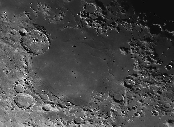
the Humorum basin. The mare itself partially fills the basin depression with an estimated 3 km thickness of lava. | the Humorum basin. The mare itself partially fills the basin depression with an estimated 3 km thickness of lava. | ||
The rim of the basin is most clearly visible in a partial arc running from SW of | The rim of the basin is most clearly visible in a partial arc running from SW of | ||
| − | [../01/LPOD-2004-01-15.htm Gassendi] south towards Liebig. Basinward of this arc is a scarp, reaching | + | ["../01/LPOD-2004-01-15.htm" Gassendi] south towards Liebig. Basinward of this arc is a scarp, reaching |
almost to Doppelmayer, that marks where the basin center dropped downward. Some of these fractures apparently | almost to Doppelmayer, that marks where the basin center dropped downward. Some of these fractures apparently | ||
allowed gas-rich magma to reach the surface making the dark-hued pyroclastic deposit and source rille west of | allowed gas-rich magma to reach the surface making the dark-hued pyroclastic deposit and source rille west of | ||
Doppelmayer. The wrinkle ridges along the eastern edges of the mare mark an inner basin ring, and the famous | Doppelmayer. The wrinkle ridges along the eastern edges of the mare mark an inner basin ring, and the famous | ||
| − | [../01/LPOD-2004-01-26.htm rilles] that cut Hippalus show where the weight of the mare lavas bent and | + | ["../01/LPOD-2004-01-26.htm" rilles] that cut Hippalus show where the weight of the mare lavas bent and |
fractured the edge terrain. And there are many more stories in this image, but we will wait for future LPODs! | fractured the edge terrain. And there are many more stories in this image, but we will wait for future LPODs! | ||
Click image above to see nomenclature. </p> | Click image above to see nomenclature. </p> | ||
Revision as of 19:59, 4 January 2015
Sea of Dryness
Image Credit: Giorgio Mengoli |
|
Sea of Dryness The classical names for the lunar dark areas were all nautical, but all were dreadful misnomers since the Moon has always lacked seas and oceans. So today, we will examine the Sea of Dryness rather than Mare Humorum, the Sea of Moisture. Regional views, such as this superb image by Giorgio Mengoli, are invaluable for understanding an entire structural portion of the Moon. Many of the details visible here relate to the impact basin structure of the Humorum basin. The mare itself partially fills the basin depression with an estimated 3 km thickness of lava. The rim of the basin is most clearly visible in a partial arc running from SW of ["../01/LPOD-2004-01-15.htm" Gassendi] south towards Liebig. Basinward of this arc is a scarp, reaching almost to Doppelmayer, that marks where the basin center dropped downward. Some of these fractures apparently allowed gas-rich magma to reach the surface making the dark-hued pyroclastic deposit and source rille west of Doppelmayer. The wrinkle ridges along the eastern edges of the mare mark an inner basin ring, and the famous ["../01/LPOD-2004-01-26.htm" rilles] that cut Hippalus show where the weight of the mare lavas bent and fractured the edge terrain. And there are many more stories in this image, but we will wait for future LPODs! Click image above to see nomenclature. Technical Details: Related Links: Tomorrow's LPOD: Max Goes to the Moon |
|
Author & Editor: Technical Consultant: A service of: |
COMMENTS?
Click on this icon File:PostIcon.jpg at the upper right to post a comment.


