Difference between revisions of "January 27, 2012"
(Created page with "__NOTOC__ =Peanuts= <!-- ws:start:WikiTextHeadingRule:0:<h1> --> <!-- ws:start:WikiTextLocalImageRule:6:<img src="/file/view/LPOD-Jan27-12.jpg/295759462/LPOD...") |
|||
| Line 2: | Line 2: | ||
=Peanuts= | =Peanuts= | ||
| − | + | <!-- ws:start:WikiTextHeadingRule:0:<h1> --> | |
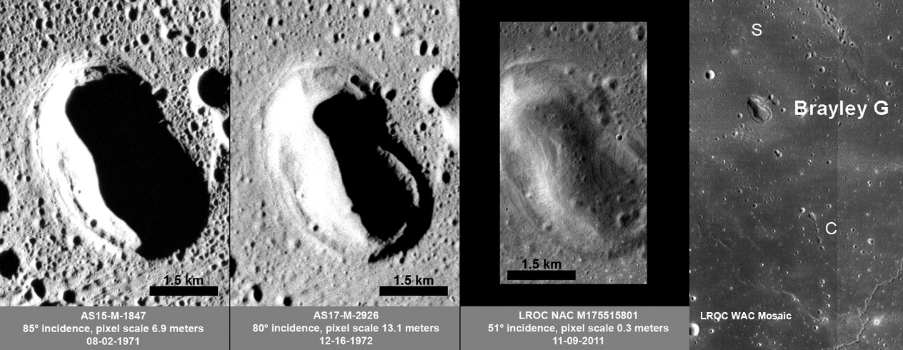
| − | + | <!-- ws:start:WikiTextLocalImageRule:6:<img src="/file/view/LPOD-Jan27-12.jpg/295759462/LPOD-Jan27-12.jpg" alt="" title="" /> -->[[File:LPOD-Jan27-12.jpg|LPOD-Jan27-12.jpg]]<!-- ws:end:WikiTextLocalImageRule:6 --><br /> | |
<em>images from [http://lroc.sese.asu.edu/news/index.php?/archives/508-Brayley-G.html#extended LRO Featured Image] (NASA/GSFC/ASU)</em><br /> | <em>images from [http://lroc.sese.asu.edu/news/index.php?/archives/508-Brayley-G.html#extended LRO Featured Image] (NASA/GSFC/ASU)</em><br /> | ||
<br /> | <br /> | ||
| Line 14: | Line 14: | ||
<br /> | <br /> | ||
<hr /> | <hr /> | ||
| − | |||
| − | |||
| − | |||
| − | |||
Revision as of 23:25, 2 January 2015
Peanuts

images from LRO Featured Image (NASA/GSFC/ASU)
Few observers probably look near the small crater Brayley in far western Mare Imbrium but as the Lunar Reconnaissance Camera team points out there is an interesting feature near by. The 3 by 5 km wide Brayley G is easily overlooked because it isn't especially deep, doesn't have rays and is nothing special, at least in most telescopic views. But with a little more magnification G is seen to not be a standard impact crater. First, impact craters are typically round in outline, not peanut-shaped. And with these orbital views it is not surrounded by an elevated rim, but in fact is one depression within another. This was recognized as a volcanic feature back in Apollo days, but there is no evidence it was a vent, a source of lava flows or ashes. It appears to have formed by collapse. That seems more likely when stepping back and looking at the surroundings. To the north is a barely perceptible sag (to the left of the letter S) of about the same size and shape as the larger depression of G. The S feature did not collapse, as completely a G, perhaps there was insufficient void under it. To the south of G is a line of five or more rimless collapse pits (C). I imagine that all of these lie above a lava tube that transported magma that ultimately erupted and became Imbrium lavas. I discovered while researching this LPOD that this reasonable interpretation occurred to me independently in 2004, so it must be right!
Chuck Wood
Related Links
Rükl plate 19


