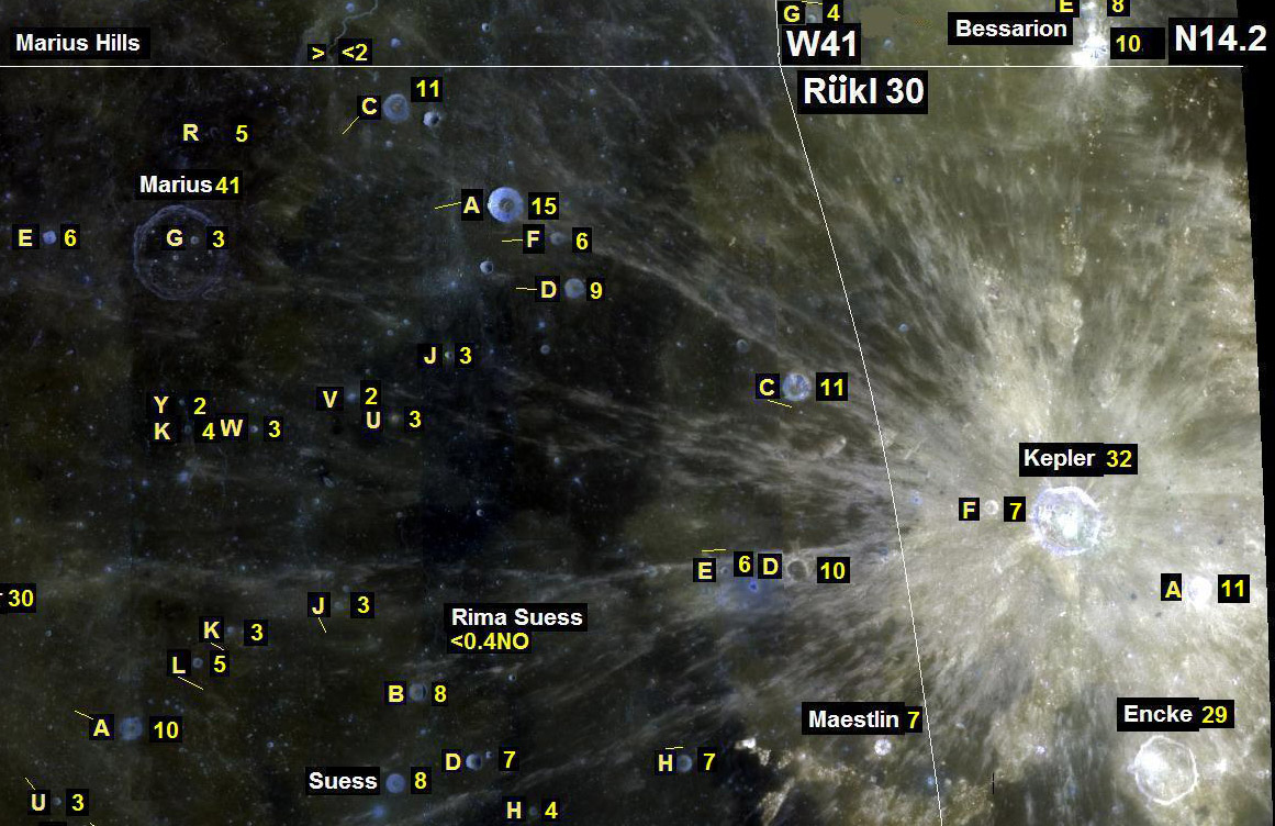
section of a reference map constructed by Kurt Fisher
I choose LPOD titles to evoke interest, mystify, and even joke. Today’s title is no joke, yet is not at all meant to belittle Kurt’s valiant effort to provide a truly useful reference for students of the Moon. Kurt has explored the possibility of constructing a photographic map that includes a variety of types of useful information. The background is a Clementine color albedo image from Map-A-Planet, on which he added feature names and designations, crater diameters and depths, and Rükl Atlas of the Moonsheet boundaries. In the excerpt above you can see the region between Kepler and Marius with designations and diameters in yellow. A second version of the map includes crater depths (where sparsely known) instead of diameters. All of this information is useful and could be very handy, if Kurt had the needed materials to start with. A major problem is that the Clementine mosaic shows albedos rather than topography for about 70% of the Moon, including this area, so it is difficult to identify and compare craters with the normal near-terminator views and images. The sinusodial projection also makes comparison with terrestrial views difficult, but that could be changed easily on future maps, if desired. The crater diameters that Kurt uses are ultimately from the measurements that I supervised in the early 1970s that are in the USGS Gazetter of Planetary Nomenclature. These were measured on Lunar Orbiter IV large scale photographs and are quite accurate. But we did not measure smaller craters unless they carried a letter designation, so there are few diameters for 0.3 to 2 km wide craters, which is where visual acuity and image resolution are tested. The crater depths are from Cherrington’s Exploring the Moon Through Binoculars and Small Telescopes and are from the early LAC maps that are based on telescopic measurements which often have large errors. For example, Kepler is shown as having a depth of 2.2 km, but is actually 2.75 km, according to measures we made on LOIV images in the early 1970s. The telescopic errors are even larger at small crater diameters - Bessarian is given as 0.9 km deep but is actually 2.0 km. I have a 30 year old print out of all depths we measured, but the only published version is from Arthur in 1974. I admire Kurt’s effort in pulling together the existing data in this experimental map, but he simply doesn’t have the right data to work with. Nobody has. Nearly 50 years after the first spacecraft to the Moon we still lack basic reference material for that body. No large scale Moon-wide maps with accurate coordinate grid. No high quality image map with constant illumination. No easily available information on crater depths and other physical characteristics. Starting with SMART-1 and the coming armada of lunar orbiters we should collect the data necessary to finally establish a fundamental mapping of the Moon. But the data have to be released so that they can be used to make maps such as this one. The question is will the data from lunar orbiters sent by ESA, China, India and the USA be released in a timely and useable way?
Technical Details:
For details on how this map was constructed see Kurt’s website.
Related Links:
D.W.G. Arthur (1974) Lunar Depths from Orbiter IV Long-Focus Photographs. Icarus 23, 116-133.
Woeful State of Lunar Imagemaps
Yesterday's LPOD: Ramadan
Tomorrow's LPOD: Steep Places on the Moon
COMMENTS?
Register, Log in, and join in the comments.


