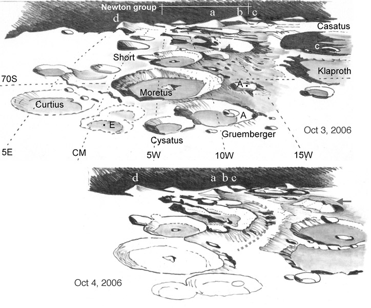
drawings by Harry Roberts, Sydney, Australia
The lunar "deep south" is a hard area to study, with masses of craters overlapping each other. So I chose to make outline maps of the terrain over two nights in an attempt to sort out the basic features. "Virtual Moon Atlas" showed that libration was not favourable, and that my first sketch (top) did not show the pole itself. On the following night I made a second sketch of the field, hoping to learn more (bottom). Conspicuous in the centre is crater Moretus, Far right (half filled with dramatic spires of shadow) is Casatus, with Klaproth below, an amazing sight! And above right of Short was a tangle of overlapping craters: the Newton complex! Clementine imagery of this area shows Newton is a mix of five or more craters, all of very different ages (Newton is 79 km diameter). Only under favourable libration can we see much of Newton’s crater floor. Amazingly, four steep, high peaks punctuated the horizon. They looked taller and more isolated than any I’d seen elsewhere on the Moon. All are about 4 - 5km high, and I labelled them "d", "a", "b" and "c". Compare with Ewen Whitaker’s classic 1954 hand drawn map. The peaks named M1 and M3 are my "a" and "b" respectively, I think. These peaks are part of the Leibnitz Range, thrown up by the South Pole Aitken impact. The bottom drawing shows how libration brings peaks "a", "b" and "c" more in line over 24 hours. Above Casatus a huge isolated massif (arrow) has appeared, that can also be seen on Clementine imagery. It looks to be 4km or so high and ~90 km long: a vast formation that doesn’t seem to be plotted or named in Rukl’s "Atlas of the Moon". The bottom image also shows a "valley" curving around Newton’s west rim, dotted in the sketch – is this a real formation or simply a space between others?
Harry Roberts
Technical Details:
See the Feb 1, 2006 LPOD for a description of Harry’s artistic techniques. The sketches have east to left and south at the top, as if we hovered above the formation (for IAU rotate 180 degrees). This was the way it looked in my C8 with a star diagonal and I find it easier to interpret landforms if they are in terrestrial orientation.
Related Links:
Rükl charts 72 & 73
Yesterday's LPOD: A Rim on the Limb Again
Tomorrow's LPOD: Seeing Double
COMMENTS?
Register, Log in, and join in the comments.


