March 21, 2012
Topographic Surprises

image by Mario Weigand
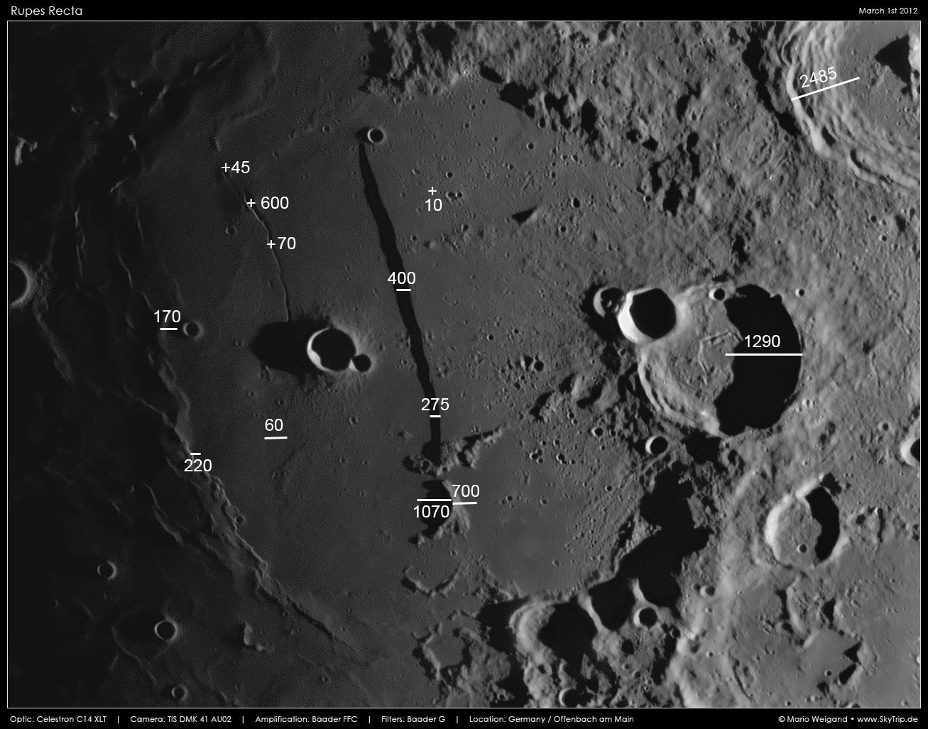
Here is another of Mario's wonderfully large images of a classic lunar area. This time I have taken the liberty of adding dimensions from the new LRO altimetry tool. (And I have unfortunately altered Mario's originally tonally perfect processing to better identify ridges and rilles along the terminator side of the image.) Starting at upper right we see that the depth from one part of Arzachel's western rim to its floor is 2,485 m. That is a very precise measurement but it doesn't go to the bottom of the crater floor and doesn't consider other portions of the rim so it doesn't represent the crater's average depth. The 1,290 m depth for Thebit is also just one cross-section, but it is less than half the 3.27 km reported depth from telescopic measurements. I suspect the telescopic data are wrong. The 400 m height for the Straight Wall at what seems to be a high point agrees reasonably with the 490 m height found by the GLR group, and other spot LRO measurements show little variation from the 400 m height. One measurement near the south end of the scarp yields a reasonable height of 275 m. Continuing down to the handle of the sword, which is made by a portion of a crater rim, LRO gives a height of 700 m above lavas to the east and 1,070 m compared to lavas on the west. This illustrates a very common occurrence - lavas often have significant slopes that we previously failed to recognize because there were no shadows to measure. Two mare ridge segments that make part of the western wall of the Ancient Thebit crater cut by the Straight Wall are higher than I would have guessed - 170 m and 220 m. The latter is similar to the height of the southern end of the Straight Wall, but because it is a gently rounded ridge rather than a sharp drop the lack of a significant shadow makes it seem less important. Once again shadows were misleading us, or at least me. Just visible on Mario's image is a vertical crease on the maria southwest of Thebit. I had thought this was a symmetrical low trough but the new data show that the elevation west of the crease is flat with only 5 m variation over 10 km. But to the east it rises 60 m in just 5 km. The crease is actually more of an inflection line, where the mostly flat western surface bends abruptly upward to the east. Jumping across the image to the east side of the Wall is a very delicate rille at right angles to it. This rille is only 10 m deep, and yet it is detectable in Mario's telescopic image. Finally lets look at the depths associated with the Birt Rille west of the Wall. At one apparently characteristic place the rille is 70 m deep. Continuing north to the vent at the summit of the small dome cut by the rille is a real surprise. The vent is 600 m deep, considerably deeper than the Wall is high. This vent would provide a greater depth range for sampling than the unique fault scarp. Finally, the second smaller dome just to the north has a vent pit that is only 45 m deep, much less surprising.
Chuck Wood
Related Links
Rükl plate 54
Yesterday's LPOD: A Moonlike View
Tomorrow's LPOD: Two-Fer
COMMENTS?
Register, Log in, and join in the comments.


