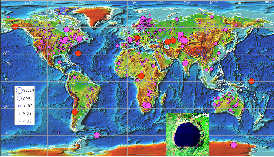
map from Alekseev, Mikheeva and Petrenko and inset Bosumtwi image (Landsat?) from their catalog
Ever since Robert Hooke investigated the possible impact origin of lunar craters in the 1660s a major argument against that interpretation has been, Where are the impact craters on Earth? In the last decades the number of known and suspected terrestrial impact craters has continually grown, and according to a Russian catalog - the source of the photo - the number of proven terrestrial impact craters is 195, with a further 512 being probable or suspected. The lake-filled crater in the inset photo is Bosumtwi, a million year old, 10 km wide crater in southern Ghana. The sizes of the circles on the map relate to the crater diameters, and the red circles are for craters larger than 500 km. Unfortunately, there is no graphical distinction between impacts that are proven or not, but the majority of proven craters are of small diameter. Impact craters shown on this map are clearly not uniformly distributed. There are two main reasons. As on other planets, older surfaces (Scandenavia, Canada, Australia) have collected craters longer and thus there are more of them. Areas that are young or have high sediment deposition rates have few craters (ocean floors, Amazon, Greenland and Antarctica). The second reason is that craters have been more intensely searched for in areas with well-established scientific traditions (Europe, US). The Earth could not have escaped the extreme cratering that pummeled the Moon, but our plate tectonics and rapid erosion has erased and hidden the vast majority of impacts formed here. Chances are there is an impact crater near you - have you visited it?
Related Links:
Rükl chart: wrong planet
Impact Field Studies Group
Earth Impact Database
Impact craters and Google Earth
Yesterday's LPOD: Woeful State of Lunar Image Maps
Tomorrow's LPOD: A Hot Day at Plato
COMMENTS?
Register, Log in, and join in the comments.


