Difference between revisions of "September 27, 2008"
| Line 6: | Line 6: | ||
<em>image by [http://wms.selene.jaxa.jp/index_j.html Kaguya Image Gallery] (select the 2008/09/26 item)</em><br /> | <em>image by [http://wms.selene.jaxa.jp/index_j.html Kaguya Image Gallery] (select the 2008/09/26 item)</em><br /> | ||
<br /> | <br /> | ||
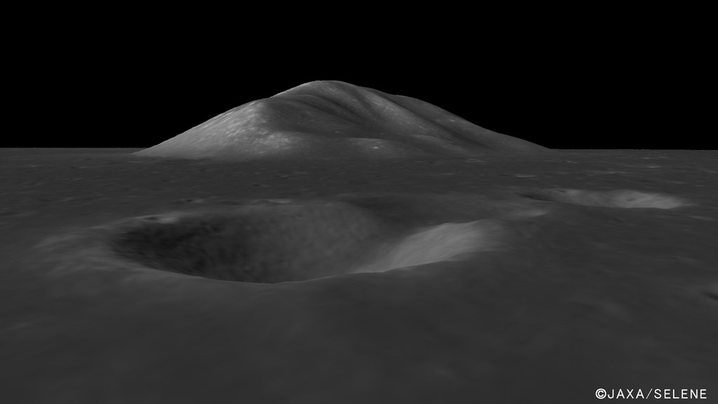
| − | I wish I knew the Japanese language! The Kaguya Image Gallery has released more images (on the Japanese section only, not the English side) from the Kaguya/Selene lunar orbiter, but text that I cut and pasted into the Google automatic translator resulted in quite garbled English. The initial Japanese screen gives the coordinates of 32.8° and 15.6° (which is latitude and which longitude?) but computer translated text talks of Pico, and that is exactly what this is: [https://the-moon.us/wiki/ | + | I wish I knew the Japanese language! The Kaguya Image Gallery has released more images (on the Japanese section only, not the English side) from the Kaguya/Selene lunar orbiter, but text that I cut and pasted into the Google automatic translator resulted in quite garbled English. The initial Japanese screen gives the coordinates of 32.8° and 15.6° (which is latitude and which longitude?) but computer translated text talks of Pico, and that is exactly what this is: [https://the-moon.us/wiki/Mons_Pico Mount Pico] at 45.7°N, 8.9°W. This is another wonderful oblique view made from stereo images used to create a digital terrain map (DTM) and then one of the images is draped over that. Pico is one of the sparse mountains that define an inner ring for the Imbrium Basin. The unnamed crater in the foreground is said (in translation) to be 1 km wide and 180 m deep. The Kaguya site gives the 2.4 km height for Pico that is in the [https://the-moon.us/wiki/Mons_Pico Moon Wiki] but that is not necessarily reliable so I hope the DTM will be used to determine a more accurate value. <br /> |
<br /> | <br /> | ||
<em>[mailto:tychocrater@yahoo.com Chuck Wood]</em><br /> | <em>[mailto:tychocrater@yahoo.com Chuck Wood]</em><br /> | ||
Latest revision as of 18:57, 13 October 2018
Peak

image by Kaguya Image Gallery (select the 2008/09/26 item)
I wish I knew the Japanese language! The Kaguya Image Gallery has released more images (on the Japanese section only, not the English side) from the Kaguya/Selene lunar orbiter, but text that I cut and pasted into the Google automatic translator resulted in quite garbled English. The initial Japanese screen gives the coordinates of 32.8° and 15.6° (which is latitude and which longitude?) but computer translated text talks of Pico, and that is exactly what this is: Mount Pico at 45.7°N, 8.9°W. This is another wonderful oblique view made from stereo images used to create a digital terrain map (DTM) and then one of the images is draped over that. Pico is one of the sparse mountains that define an inner ring for the Imbrium Basin. The unnamed crater in the foreground is said (in translation) to be 1 km wide and 180 m deep. The Kaguya site gives the 2.4 km height for Pico that is in the Moon Wiki but that is not necessarily reliable so I hope the DTM will be used to determine a more accurate value.
Chuck Wood
Related Links
Rükl plate 11
Yesterday's LPOD: A Wondrous Image
Tomorrow's LPOD: Secondary Matters
COMMENTS?
Register, Log in, and join in the comments.


