February 11, 2004
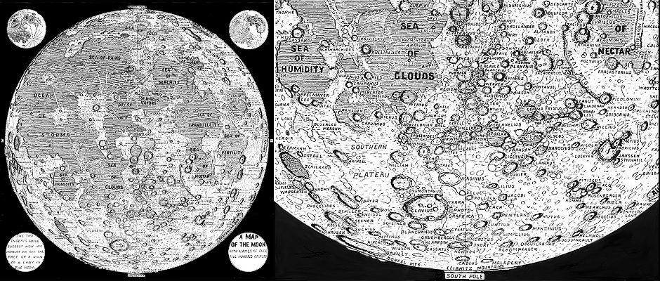
I drew a map so I get to add names
Image Credit: Pacific Discovery, March-April, 1959 |
|
I Drew a Lunar Map So I Get to Add Names! Somewhere, a decade or so ago, I picked up a single page from an old Pacific Discovery magazine that contained this map. Its obviously a hand drawn one, with a lot of effort spent depicting hundreds of craters with many slightly jiggly lines representing the maria. The map apparently helped illustrate an article on adjacent pages, and according to a caption, was available for five cents at the Planetarium book counter. Just now, due to the glory of the Internet, I found a complete index of Pacific Discovery (now called California Wild) and discovered that the article was "The Mountains of the Moon" and was written by G.W. Bunton! The map contains nearly all of the existing lunar nomenclature, with the Latin names for maria translated to English (Sea of Cold for Mare Frigoris). Interestingly, the old British name for the Straight Wall - Railway - is used, but a number of totally unofficial names have also snook in. "Southern Plateau" is visible on the enlargement above and to the left of Clavius, while immediately to that crater's right is "Terra Photographica." I like the Latinization, which lends a patina of ancient respectability to a brand new name! Did you ever notice the line of craters stretching from Gemma Frisius toward Rabbi Levi? This map's author did and practically named it "The Link." Near Apollonius is the "Bitterroot Meadows" and the patch of cratered obscurity east of Palus Somni is labeled "Coxwell Mts." The inventiveness continues with "Rainbow Heights" for the area north of the Jura Mts. What we now call Palus Epidemiarum is restfully called "Bluereed Meadow," but my favorite is "Honey Lake" which seems to be a mare patch south of Vieta. This delightful map and its pastoral new names has not wormed its way into any other book, but I doubt if I can ever again look west of Plato without thinking of Rainbow Heights! Related Links: |
|
Author & Editor: Technical Consultant: A service of: |
COMMENTS?
Register, and click on the Discussion tab at the top of the page.


