Difference between revisions of "September 13, 2013"
(Created page with "__NOTOC__ =Another Small Mystery= <!-- ws:start:WikiTextHeadingRule:0:<h1> --> <!-- ws:start:WikiTextLocalImageRule:14:<img src="/file/view/LPOD-Sept13-13.jp...") |
|||
| (7 intermediate revisions by the same user not shown) | |||
| Line 1: | Line 1: | ||
__NOTOC__ | __NOTOC__ | ||
=Another Small Mystery= | =Another Small Mystery= | ||
| − | + | <!-- Start of content --> | |
| − | + | <!-- ws:start:WikiTextHeadingRule:0:<h1> --> | |
| − | + | <!-- ws:start:WikiTextLocalImageRule:14:<img src="/file/view/LPOD-Sept13-13.jpg/450748822/LPOD-Sept13-13.jpg" alt="" title="" style="width: 950px;" /> -->[[File:LPOD-Sept13-13.jpg|LPOD-Sept13-13.jpg]]<!-- ws:end:WikiTextLocalImageRule:14 --><br /> | |
<em>image by [mailto:tolentino@fumec.br Ricardo Jose Vaz Tolentino]</em><br /> | <em>image by [mailto:tolentino@fumec.br Ricardo Jose Vaz Tolentino]</em><br /> | ||
| − | + | <table class="wiki_table"> | |
| + | <tr> | ||
| + | <td><!-- ws:start:WikiTextLocalImageRule:15:<img src="/file/view/LPOD-Sept13-13b.jpg/450753978/LPOD-Sept13-13b.jpg" alt="" title="" /> -->[[File:LPOD-Sept13-13b.jpg|LPOD-Sept13-13b.jpg]]<!-- ws:end:WikiTextLocalImageRule:15 --><br /> | ||
</td> | </td> | ||
| − | + | <td>Recently, Maximilian Teodorescu recognized what might be a shallow [http://www2.lpod.org/wiki/September_10,_2013 crater] in southern Oceanus Procellarum, and now Ricardo has found another possible one in the northern part of the same ocean. Using one of his single shot images, Ricardo has outlined the area of the possible crater between the famous Gruithuisen domes and the even more famous Aristarchus Plateau. Using the LRO Quickmap elevation tool he deduced that the crater is about 8.5 km wide, 130 m deep and centered at 32.3980*N, 42.7580*W. Like Max's possible crater this one is bounded on one side by a mare ridge, which makes determination of its reality harder. Is it an impact crater that happens to be near a ridge, and partially covered by lava flows? Or is the ridge flanked by a low trough that makes a crater feature appear where none exist? LRO provides two kinds of support for the reality of this feature. First, Ricardo ran traverses both north-south and east-west, getting the same type of closed depression topography. Second, enlarging the LRO mosaic to see the NAC shots - left - reveals two very low elevation curved ridges that are in the right place to be the curved rim of a buried crater. For this type of feature we may never be certain what it is, but a buried crater seems like a likely possibility.<br /> | |
<br /> | <br /> | ||
<em>[mailto:tychocrater@yahoo.com Chuck Wood]</em><br /> | <em>[mailto:tychocrater@yahoo.com Chuck Wood]</em><br /> | ||
| Line 15: | Line 17: | ||
<br /> | <br /> | ||
<strong>Related Links</strong><br /> | <strong>Related Links</strong><br /> | ||
| − | <em>[ | + | <em>[[21st Century Atlas of the Moon|21st Century Atlas]]</em> chart 21.<br /> |
Rukl's Atlas of the Moon: chart 9 (shows the above described depression!).<br /> | Rukl's Atlas of the Moon: chart 9 (shows the above described depression!).<br /> | ||
Times Atlas of the Moon: chart 15 (it too shows that depression).<br /> | Times Atlas of the Moon: chart 15 (it too shows that depression).<br /> | ||
</td> | </td> | ||
| − | + | </tr> | |
</table> | </table> | ||
| − | |||
<br /> | <br /> | ||
| + | <p><b>Yesterday's LPOD:</b> [[September 12, 2013|40 Years Later]] </p> | ||
| + | <p><b>Tomorrow's LPOD:</b> [[September 14, 2013|Farside 50 - Almost]] </p> | ||
<hr /> | <hr /> | ||
| − | + | {{wiki/ArticleFooter}} | |
| − | |||
| − | |||
| − | |||
| − | |||
Latest revision as of 07:36, 28 October 2018
Another Small Mystery

image by Ricardo Jose Vaz Tolentino
 |
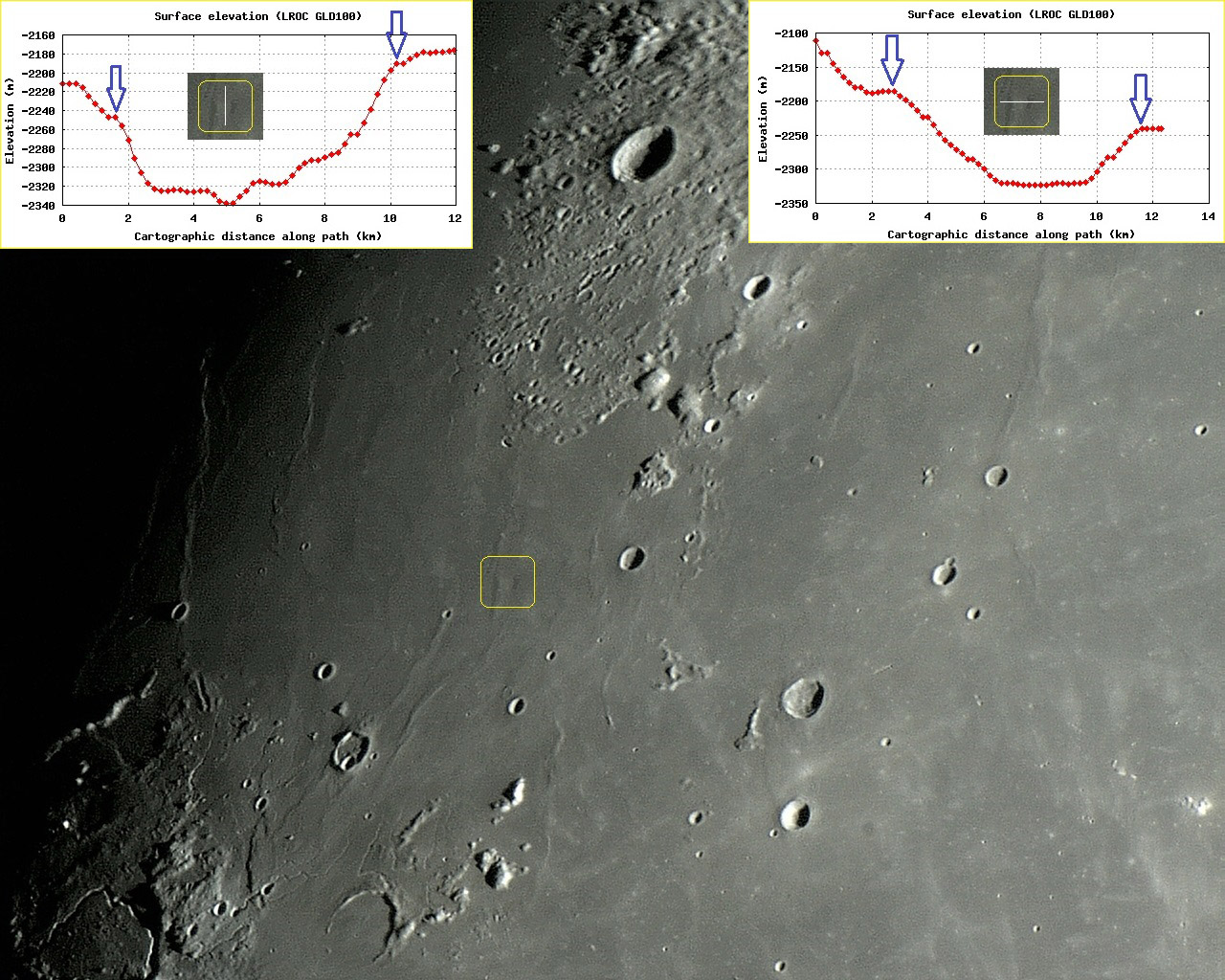
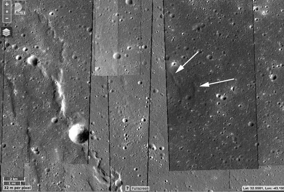
Recently, Maximilian Teodorescu recognized what might be a shallow crater in southern Oceanus Procellarum, and now Ricardo has found another possible one in the northern part of the same ocean. Using one of his single shot images, Ricardo has outlined the area of the possible crater between the famous Gruithuisen domes and the even more famous Aristarchus Plateau. Using the LRO Quickmap elevation tool he deduced that the crater is about 8.5 km wide, 130 m deep and centered at 32.3980*N, 42.7580*W. Like Max's possible crater this one is bounded on one side by a mare ridge, which makes determination of its reality harder. Is it an impact crater that happens to be near a ridge, and partially covered by lava flows? Or is the ridge flanked by a low trough that makes a crater feature appear where none exist? LRO provides two kinds of support for the reality of this feature. First, Ricardo ran traverses both north-south and east-west, getting the same type of closed depression topography. Second, enlarging the LRO mosaic to see the NAC shots - left - reveals two very low elevation curved ridges that are in the right place to be the curved rim of a buried crater. For this type of feature we may never be certain what it is, but a buried crater seems like a likely possibility.
|
Yesterday's LPOD: 40 Years Later
Tomorrow's LPOD: Farside 50 - Almost
COMMENTS?
Register, Log in, and join in the comments.


