Difference between revisions of "July 7, 2008"
(Created page with "__NOTOC__ =Apollo 17 Stunner= <!-- ws:start:WikiTextHeadingRule:1:<h1> --> <!-- ws:start:WikiTextLocalImageRule:7:<img src="/file/view/LPOD-July7-08.jpg/34929675...") |
|||
| (3 intermediate revisions by the same user not shown) | |||
| Line 1: | Line 1: | ||
__NOTOC__ | __NOTOC__ | ||
=Apollo 17 Stunner= | =Apollo 17 Stunner= | ||
| + | <!-- Start of content --> | ||
<!-- ws:start:WikiTextHeadingRule:1:<h1> --> | <!-- ws:start:WikiTextHeadingRule:1:<h1> --> | ||
<!-- ws:start:WikiTextLocalImageRule:7:<img src="/file/view/LPOD-July7-08.jpg/34929675/LPOD-July7-08.jpg" alt="" title="" /> -->[[File:LPOD-July7-08.jpg|LPOD-July7-08.jpg]]<!-- ws:end:WikiTextLocalImageRule:7 --><br /> | <!-- ws:start:WikiTextLocalImageRule:7:<img src="/file/view/LPOD-July7-08.jpg/34929675/LPOD-July7-08.jpg" alt="" title="" /> -->[[File:LPOD-July7-08.jpg|LPOD-July7-08.jpg]]<!-- ws:end:WikiTextLocalImageRule:7 --><br /> | ||
| Line 6: | Line 7: | ||
<br /> | <br /> | ||
<!-- ws:start:WikiTextLocalImageRule:8:<img src="/file/view/LPOD-July7-08b.jpg/34929685/LPOD-July7-08b.jpg" alt="" title="" align="left" /> -->[[File:LPOD-July7-08b.jpg|LPOD-July7-08b.jpg]]<!-- ws:end:WikiTextLocalImageRule:8 --> <br /> | <!-- ws:start:WikiTextLocalImageRule:8:<img src="/file/view/LPOD-July7-08b.jpg/34929685/LPOD-July7-08b.jpg" alt="" title="" align="left" /> -->[[File:LPOD-July7-08b.jpg|LPOD-July7-08b.jpg]]<!-- ws:end:WikiTextLocalImageRule:8 --> <br /> | ||
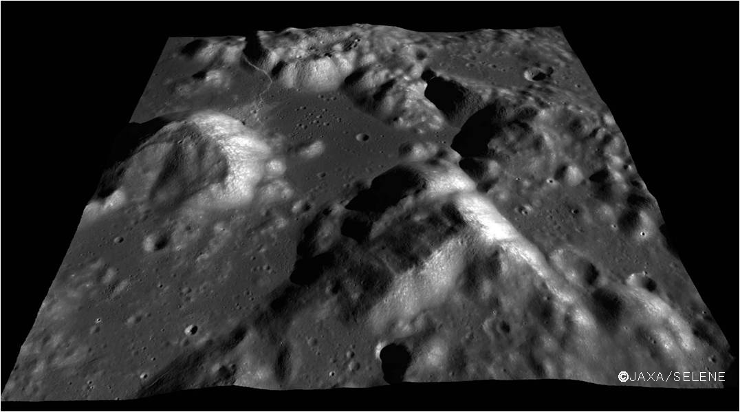
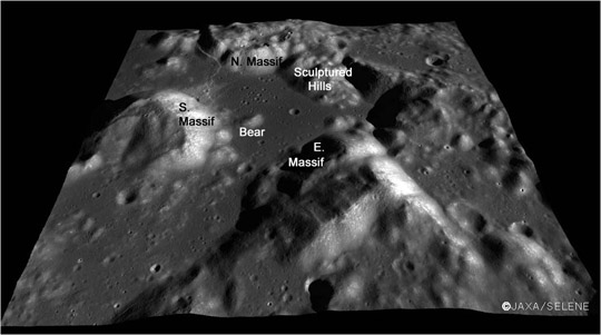
| − | Kaguya is back. A few images were released in June that continue to demonstrate the high quality of this spacecraft's sensors, and make us lust for more. This view made from images from the high resolution Terrain Camera is draped over a digital terrain model constructed from the stereo images - at least, that is what I assume since the caption is only available in Japanese. This is the most informative image I've ever seen of the Apollo 17 area. The view appears to be from some tens of kilometers up looking northward over the [ | + | Kaguya is back. A few images were released in June that continue to demonstrate the high quality of this spacecraft's sensors, and make us lust for more. This view made from images from the high resolution Terrain Camera is draped over a digital terrain model constructed from the stereo images - at least, that is what I assume since the caption is only available in Japanese. This is the most informative image I've ever seen of the Apollo 17 area. The view appears to be from some tens of kilometers up looking northward over the [https://the-moon.us/wiki/Taurus-Littrow_Valley Taurus-Littrow Valley]. Apollo 17 landed near the largest and westmost crater - [https://the-moon.us/wiki/Camelot Camelot] - of the secondary crater cluster south of North Massif. From this perspective the Sculptured Hills appear to be a jumble of mountainous masses that slumped off the mountain immediately to the east, creating the imposing scarp. This view also re-emphasizes the weirdness of the low scarp that crosses from near South Massif and rises part way up the flank of North Massif. If this is a mare ridge it is much further from the main mare than most ridges. Hmm. <br /> |
<br /> | <br /> | ||
<em>[mailto:tychocrater@yahoo.com Chuck Wood]</em><br /> | <em>[mailto:tychocrater@yahoo.com Chuck Wood]</em><br /> | ||
| Line 14: | Line 15: | ||
[http://www.lpi.usra.edu/meetings/lpsc2008/pdf/1308.pdf Terrain Camera] - first results<br /> | [http://www.lpi.usra.edu/meetings/lpsc2008/pdf/1308.pdf Terrain Camera] - first results<br /> | ||
<br /> | <br /> | ||
| + | <p><b>Yesterday's LPOD:</b> [[July 6, 2008|Mare Pacificus]] </p> | ||
| + | <p><b>Tomorrow's LPOD:</b> [[July 8, 2008|Four in a Row]] </p> | ||
<hr /> | <hr /> | ||
| − | |||
{{wiki/ArticleFooter}} | {{wiki/ArticleFooter}} | ||
Latest revision as of 17:49, 13 October 2018
Apollo 17 Stunner

image by Kaguya Image Gallery, (c) JAXA/SELENE

Kaguya is back. A few images were released in June that continue to demonstrate the high quality of this spacecraft's sensors, and make us lust for more. This view made from images from the high resolution Terrain Camera is draped over a digital terrain model constructed from the stereo images - at least, that is what I assume since the caption is only available in Japanese. This is the most informative image I've ever seen of the Apollo 17 area. The view appears to be from some tens of kilometers up looking northward over the Taurus-Littrow Valley. Apollo 17 landed near the largest and westmost crater - Camelot - of the secondary crater cluster south of North Massif. From this perspective the Sculptured Hills appear to be a jumble of mountainous masses that slumped off the mountain immediately to the east, creating the imposing scarp. This view also re-emphasizes the weirdness of the low scarp that crosses from near South Massif and rises part way up the flank of North Massif. If this is a mare ridge it is much further from the main mare than most ridges. Hmm.
Chuck Wood
Related Links
Rükl plate 25
Terrain Camera - first results
Yesterday's LPOD: Mare Pacificus
Tomorrow's LPOD: Four in a Row
COMMENTS?
Register, Log in, and join in the comments.


