Difference between revisions of "February 13, 2014"
| Line 1: | Line 1: | ||
__NOTOC__ | __NOTOC__ | ||
=Plateauing Out= | =Plateauing Out= | ||
| − | |||
<!-- ws:start:WikiTextHeadingRule:0:<h1> --> | <!-- ws:start:WikiTextHeadingRule:0:<h1> --> | ||
<!-- ws:start:WikiTextLocalImageRule:6:<img src="/file/view/LPOD-Feb13-14.jpg/489176296/LPOD-Feb13-14.jpg" alt="" title="" /> -->[[File:LPOD-Feb13-14.jpg|LPOD-Feb13-14.jpg]]<!-- ws:end:WikiTextLocalImageRule:6 --><br /> | <!-- ws:start:WikiTextLocalImageRule:6:<img src="/file/view/LPOD-Feb13-14.jpg/489176296/LPOD-Feb13-14.jpg" alt="" title="" /> -->[[File:LPOD-Feb13-14.jpg|LPOD-Feb13-14.jpg]]<!-- ws:end:WikiTextLocalImageRule:6 --><br /> | ||
| − | <em>image by [mailto:tolentino@fumec.br Prof. Ricardo Jose Vaz Tolentino]</em><br /> | + | <em>image by [mailto:tolentino@fumec.br" rel="nofollow Prof. Ricardo Jose Vaz Tolentino]</em><br /> |
<br /> | <br /> | ||
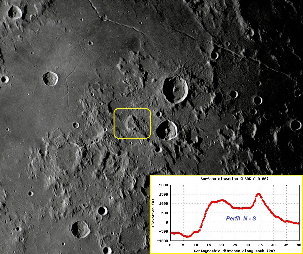
Southeast of [http://the-moon.wikispaces.com/Dembowski Dembowski] (diameter: 26 km, depth: 1 km) and west of [http://the-moon.wikispaces.com/Godin Godin] (diameter: 34 km, depth: 3.4 km ) is a strange, rare, salient and understudied formation, characterized as a prominent plateau that rises above the surrounding surface. The formation is approximately 25 km X 20 km in maximum dimensions at its base. The highest point of this unusual formation reaches about 2.3 Km in relation to the lower region of the surrounding surface. On the upper face of the this interesting plateau is a wide, flat, horizontal and relatively smooth area, like a big table. This horizontal surface is at an altitude of approximately 1.5 Km compared to the lower surface of the surrounding region, and has approximately an area of 50 Km2, or substantially the same area occupied by a crater with 8 km in diameter. This detached flat surface hosts inside a tiny crater about 2 km in diameter. Another small crater 3 km in diameter is positioned on its southern edge.<br /> | Southeast of [http://the-moon.wikispaces.com/Dembowski Dembowski] (diameter: 26 km, depth: 1 km) and west of [http://the-moon.wikispaces.com/Godin Godin] (diameter: 34 km, depth: 3.4 km ) is a strange, rare, salient and understudied formation, characterized as a prominent plateau that rises above the surrounding surface. The formation is approximately 25 km X 20 km in maximum dimensions at its base. The highest point of this unusual formation reaches about 2.3 Km in relation to the lower region of the surrounding surface. On the upper face of the this interesting plateau is a wide, flat, horizontal and relatively smooth area, like a big table. This horizontal surface is at an altitude of approximately 1.5 Km compared to the lower surface of the surrounding region, and has approximately an area of 50 Km2, or substantially the same area occupied by a crater with 8 km in diameter. This detached flat surface hosts inside a tiny crater about 2 km in diameter. Another small crater 3 km in diameter is positioned on its southern edge.<br /> | ||
<br /> | <br /> | ||
| − | <em>[mailto:tolentino@fumec.br Prof. Ricardo Jose Vaz Tolentino]</em><br /> | + | <em>[mailto:tolentino@fumec.br" rel="nofollow Prof. Ricardo Jose Vaz Tolentino]</em><br /> |
<br /> | <br /> | ||
<strong>Technical Details</strong><br /> | <strong>Technical Details</strong><br /> | ||
| Line 15: | Line 14: | ||
<strong>Related Links</strong><br /> | <strong>Related Links</strong><br /> | ||
<em>[http://lpod.wikispaces.com/21st+Century+Atlas+of+the+Moon 21st Century Atlas]</em> chart 12.<br /> | <em>[http://lpod.wikispaces.com/21st+Century+Atlas+of+the+Moon 21st Century Atlas]</em> chart 12.<br /> | ||
| − | RIcardo's [ | + | RIcardo's [/www.vaztolentino.com.br Website]<br /> |
<hr /> | <hr /> | ||
Revision as of 21:56, 4 January 2015
Plateauing Out

image by " rel="nofollow Prof. Ricardo Jose Vaz Tolentino
Southeast of Dembowski (diameter: 26 km, depth: 1 km) and west of Godin (diameter: 34 km, depth: 3.4 km ) is a strange, rare, salient and understudied formation, characterized as a prominent plateau that rises above the surrounding surface. The formation is approximately 25 km X 20 km in maximum dimensions at its base. The highest point of this unusual formation reaches about 2.3 Km in relation to the lower region of the surrounding surface. On the upper face of the this interesting plateau is a wide, flat, horizontal and relatively smooth area, like a big table. This horizontal surface is at an altitude of approximately 1.5 Km compared to the lower surface of the surrounding region, and has approximately an area of 50 Km2, or substantially the same area occupied by a crater with 8 km in diameter. This detached flat surface hosts inside a tiny crater about 2 km in diameter. Another small crater 3 km in diameter is positioned on its southern edge.
" rel="nofollow Prof. Ricardo Jose Vaz Tolentino
Technical Details
05/01/2013; 03:06:34 LT (06:06:34 UT). Sky-Watcher Collapsible Truss-Tube DOB 12" + Celestron Ultima 2X Barlow + Orion StarShoot Solar System Color Imager III Camera (just 1 frame). All measurements presented in the text below were obtained in QuickMap.
Related Links
21st Century Atlas chart 12.
RIcardo's [/www.vaztolentino.com.br Website]


