July 28, 2004
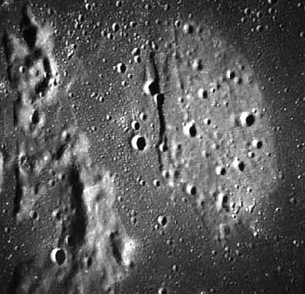
Cognitum Kipuka
Image Credit: Apollo 16 frame 120-19247 |
|
Cognitum Kipuka Kipuka is a Hawaiian word for an island. In volcanology it is an island of older land surrounded by a younger lava flow. In the middle of Mare Cognitum - the Known Sea (known because it is where Ranger 7 acquired the first high resolution images of the Moon) - are a number of kipukas. In fact, Mare Insularum, Mare Nubium and the southern end of Oceanus Procellarum are all shallow seas with relict crater rims poking up. But kipukas are usually thought of as being flatter than crater rims - like previous flat-lying ground that is preserved just because it happened to be a little higher than younger lavas. In this case, the kipuka is an 18 km long, D-shaped piece of lighter-hued land that has a Greek letter designation: Darney Chi. Compared to the surrounding dark mare, the surface of Chi looks older because it has more "large" craters and is crossed by almost eroded away rilles. The fact that the western edge of Chi is straight-sided - as is to a lesser degree the ridges to the west - suggests that a graben (a fault-bounded linear depression) may occur on the left side of Chi. Related Links: Yesterday's LPOD: What is a Dome? Tomorrow's LPOD: EAW & GPK |
Author & Editor: |
COMMENTS?
Register, Log in, and join in the comments.


