June 2, 2015
Posidonius: Rilles and Uplift
Originally published June 1, 2004
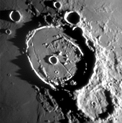
Posidonius: Rilles and Uplift Posidonius is a beacon of interest along the otherwise bland north-eastern shore of Serenitatis. The large (95 km wide, 2.3 km max depth crater may have originally looked like Copernicus with broad terraced walls and a scattering of peaks centered on a deep, flat floor. But thats not how it looks now! As this excellent photo by Jim Phillips shows the inner walls are narrow ridges (at least on the mare side), the floor is shallow, wide and covered with arcuate mountains, hills and rilles. How did the transformation take place? Like Petavius, Posidonius is a floor-fractured crater. Rising magma ponded under Posidonius, uplifting and fracturing its floor. Lava also leaked out and partially filled the crater and created the sinuous rille. The small semi-circle of peaks near the center may be the tops of a lava-large buried central peak complex. The arcuate mountains near the east and west walls are more mysterious - are they uplifted floor or isolated portions of terraces? Take a look! Originally posted January 9, 2004 Related Links: Yesterday's LPOD: Ten Day Old Moon Tomorrow's LPOD: Gassendi |
Author & Editor:
Charles A. Wood
COMMENTS?
Register, Log in, and join in the comments.


