Difference between revisions of "April 15, 2018"
(Created page with "__NOTOC__ =Edges of Uplift= Originally published December 5, 2008 <!-- Start of content --> <!-- ws:start:WikiTextHeadingRule:1:<h1> --> <!-- ws:start:WikiTextLocal...") |
|||
| Line 7: | Line 7: | ||
<em>image by [mailto:s_fire@online.ua Pavel Presnyakov], Kiev, Ukraine</em><br /> | <em>image by [mailto:s_fire@online.ua Pavel Presnyakov], Kiev, Ukraine</em><br /> | ||
<br /> | <br /> | ||
| − | The Aristarchus Plateau - or [ | + | The Aristarchus Plateau - or [https://the-moon.us/wiki/Aristarchus+Plateau Wood's Spot,] the other unofficial name that I naturally prefer to use - is thought to be an uplifted block of lunar crust. Schröter's Valley and the smaller sinuous rilles nearby demonstrate that the area was the source for many lava flows, as well as the large pyroclastic deposit that drapes the Plateau. So probably the uprising magma that fed the rilles also raised up the Plateau. But why does it have the rectangular shape? The southern edge is roughly radial to the center of the Imbrium Basin, but none of the other boundaries have suggestive alignments. Even if we don't understand the reason for the shape lets look at each edge to see how they relate to the surrounding maria. The continuous ejecta from Aristarchus obviously drapes over Procellarum lavas and the Plateau. Just west of the crater is the most abrupt edge of the entire uplift - [http://www3.nhk.or.jp/kaguya/archive/original/kaguya046.jpg a bright scarp]. If this were part of the rim of a now-gone crater it would have been a very large one. More likely this is a fault scarp, showing that the Plateau was raised up along faulted boundaries. The west side of the Plateau slopes gently towards the mare, and lavas - probably from the Schröter's Valley - embay the edges, icluding burying most of two rilles that paralleled the edge. Along the north the Plateau has a sharp edge with a strait of mare separating it from the [https://the-moon.us/wiki/Montes+Agricola Agricola Mountains]. Did they used to be contiguous with the Plateau and somehow moved away? The eastern edge is the most complex, with islands of Plateau-textured roughness. The Toscanelli Fault faces toward the Plateau rather than away as expected. An upraised slab between the Fault and Schröter's Valley demonstrates that the Plateau was not lifted up as one continuous block. This side of the Plateau was also the source for multiple sinuous rilles - perhaps the faults provides easy conduits for magma to escape to the surface. Now we are back to Aristarchus. Catch your breath and then start around again to see what other features you missed the first time!<br /> |
<br /> | <br /> | ||
<em>[mailto:tychocrater@yahoo.com Chuck Wood]</em><br /> | <em>[mailto:tychocrater@yahoo.com Chuck Wood]</em><br /> | ||
| Line 15: | Line 15: | ||
<br /> | <br /> | ||
<strong>Related Links</strong><br /> | <strong>Related Links</strong><br /> | ||
| − | Rükl plate [ | + | Rükl plate [https://the-moon.us/wiki/Rukl+18 18]<br /> |
<br /> | <br /> | ||
<p><b>Yesterday's LPOD:</b> [[April 14, 2018|Postage Stamps]] </p> | <p><b>Yesterday's LPOD:</b> [[April 14, 2018|Postage Stamps]] </p> | ||
Revision as of 18:01, 18 August 2018
Edges of Uplift
Originally published December 5, 2008

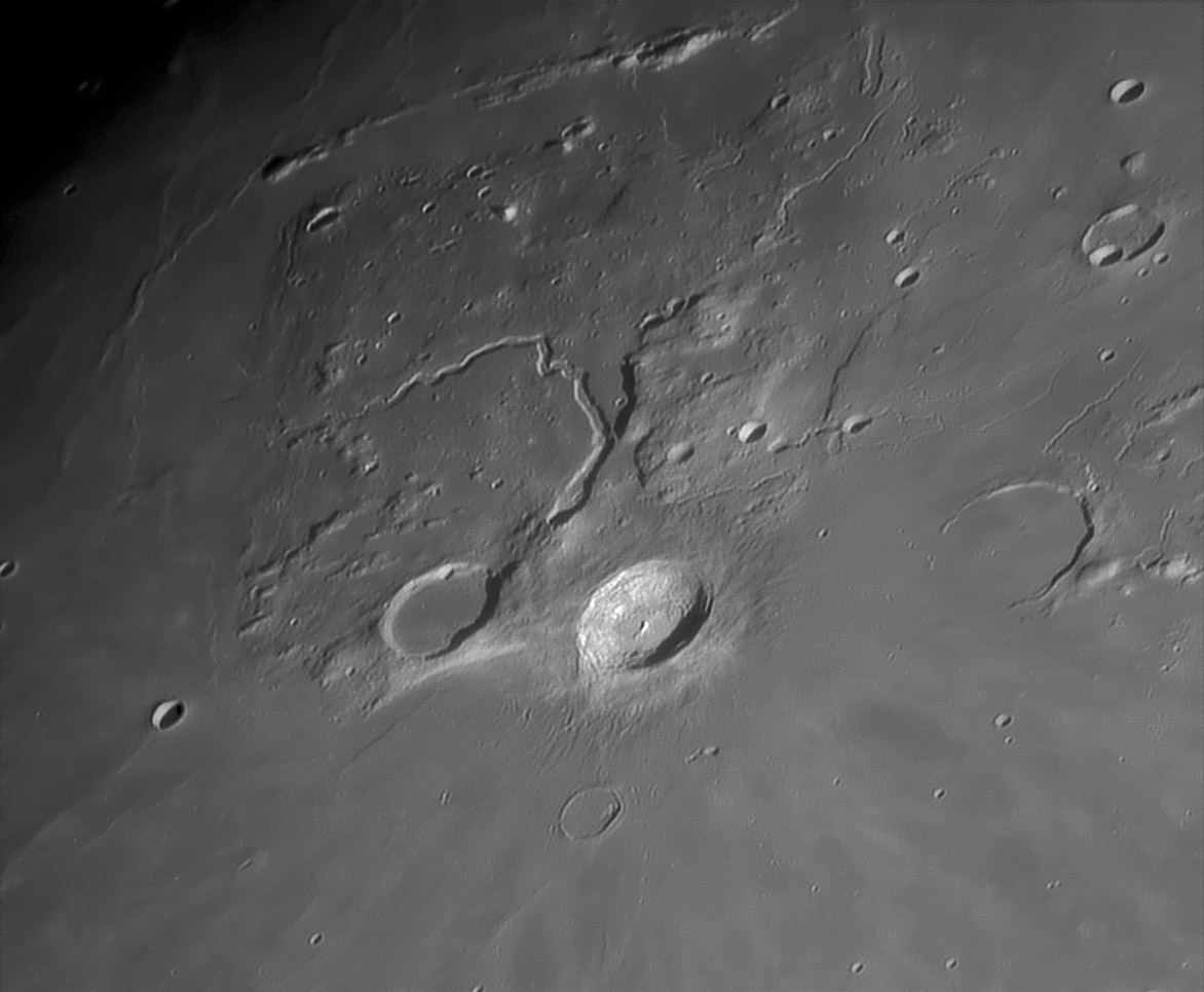
image by Pavel Presnyakov, Kiev, Ukraine
The Aristarchus Plateau - or Wood's Spot, the other unofficial name that I naturally prefer to use - is thought to be an uplifted block of lunar crust. Schröter's Valley and the smaller sinuous rilles nearby demonstrate that the area was the source for many lava flows, as well as the large pyroclastic deposit that drapes the Plateau. So probably the uprising magma that fed the rilles also raised up the Plateau. But why does it have the rectangular shape? The southern edge is roughly radial to the center of the Imbrium Basin, but none of the other boundaries have suggestive alignments. Even if we don't understand the reason for the shape lets look at each edge to see how they relate to the surrounding maria. The continuous ejecta from Aristarchus obviously drapes over Procellarum lavas and the Plateau. Just west of the crater is the most abrupt edge of the entire uplift - a bright scarp. If this were part of the rim of a now-gone crater it would have been a very large one. More likely this is a fault scarp, showing that the Plateau was raised up along faulted boundaries. The west side of the Plateau slopes gently towards the mare, and lavas - probably from the Schröter's Valley - embay the edges, icluding burying most of two rilles that paralleled the edge. Along the north the Plateau has a sharp edge with a strait of mare separating it from the Agricola Mountains. Did they used to be contiguous with the Plateau and somehow moved away? The eastern edge is the most complex, with islands of Plateau-textured roughness. The Toscanelli Fault faces toward the Plateau rather than away as expected. An upraised slab between the Fault and Schröter's Valley demonstrates that the Plateau was not lifted up as one continuous block. This side of the Plateau was also the source for multiple sinuous rilles - perhaps the faults provides easy conduits for magma to escape to the surface. Now we are back to Aristarchus. Catch your breath and then start around again to see what other features you missed the first time!
Chuck Wood
Technical Details
10.11.2008 20:33 UT. 350 mm newtonian + barlow 3x + Vac-135, b/w 1280x1024; 486 frames from 2500 in AviStack and Registax.
Related Links
Rükl plate 18
Yesterday's LPOD: Postage Stamps
Tomorrow's LPOD: The Envelope Please
COMMENTS?
Register, Log in, and join in the comments.


