Difference between revisions of "June 28, 2004"
| Line 19: | Line 19: | ||
<table class="story" border="0" bgcolor="#FFFFFF" width="90%" cellpadding="10" align="center"><tr><td> | <table class="story" border="0" bgcolor="#FFFFFF" width="90%" cellpadding="10" align="center"><tr><td> | ||
<p class="story" align="center"><b>LACs and More!</b></p> | <p class="story" align="center"><b>LACs and More!</b></p> | ||
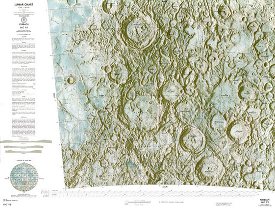
| − | <p class="story" align="left">Without saying a word, a treasury of [http://www.lpi.usra.edu/research/mapcatalog/ lunar maps] has appeared online. The [http://www.lpi.usra.edu/research/lunar_atlases/ Lunar Atlases] section of the Lunar & Planetary Institute website has been an invaluable resource for Lunar Orbiter IV, Consolidated Lunar Atlas and Apollo handheld images. On June 24, the good people at LPI added digitized versions of various lunar maps. So far, the star of the site is the collection of 44 classic Lunar Aeronautical Charts (LACs) covering the central region of the lunar nearside. These are available in three file sizes: the 108 kB browse image reproduced here, an 877 kB high-res JPEG version, and a monstrous 170 MB full-res TIFF version! The hi-res version is almost good enough to read the contours - for example, it looks like the Straight Wall is measured as 410 m high; but I hesitate to start downloading the TIFF file to confirm that number! The website also includes two 10,000,000 charts, but what is really exciting is that they will be adding the 1:250,000 Lunar Topographic Orthophotomaps ([ | + | <p class="story" align="left">Without saying a word, a treasury of [http://www.lpi.usra.edu/research/mapcatalog/ lunar maps] has appeared online. The [http://www.lpi.usra.edu/research/lunar_atlases/ Lunar Atlases] section of the Lunar & Planetary Institute website has been an invaluable resource for Lunar Orbiter IV, Consolidated Lunar Atlas and Apollo handheld images. On June 24, the good people at LPI added digitized versions of various lunar maps. So far, the star of the site is the collection of 44 classic Lunar Aeronautical Charts (LACs) covering the central region of the lunar nearside. These are available in three file sizes: the 108 kB browse image reproduced here, an 877 kB high-res JPEG version, and a monstrous 170 MB full-res TIFF version! The hi-res version is almost good enough to read the contours - for example, it looks like the Straight Wall is measured as 410 m high; but I hesitate to start downloading the TIFF file to confirm that number! The website also includes two 10,000,000 charts, but what is really exciting is that they will be adding the 1:250,000 Lunar Topographic Orthophotomaps ([[March_27,_2004|LTO]]). This is the largest scale and highest resolution lunar map series ever made (don't hassle me about Apollo landing maps, etc - they are different!) and have been widely unavailable for decades! All praise LPI! </p> |
<blockquote> | <blockquote> | ||
<p align="right" class="story">— [mailto:tychocrater@yahoo.com Chuck Wood]</p></blockquote> | <p align="right" class="story">— [mailto:tychocrater@yahoo.com Chuck Wood]</p></blockquote> | ||
Revision as of 12:37, 17 January 2015
LACs and More!
Image Credit: Lunar & Planetary Institute, Houston |
|
LACs and More! Without saying a word, a treasury of lunar maps has appeared online. The Lunar Atlases section of the Lunar & Planetary Institute website has been an invaluable resource for Lunar Orbiter IV, Consolidated Lunar Atlas and Apollo handheld images. On June 24, the good people at LPI added digitized versions of various lunar maps. So far, the star of the site is the collection of 44 classic Lunar Aeronautical Charts (LACs) covering the central region of the lunar nearside. These are available in three file sizes: the 108 kB browse image reproduced here, an 877 kB high-res JPEG version, and a monstrous 170 MB full-res TIFF version! The hi-res version is almost good enough to read the contours - for example, it looks like the Straight Wall is measured as 410 m high; but I hesitate to start downloading the TIFF file to confirm that number! The website also includes two 10,000,000 charts, but what is really exciting is that they will be adding the 1:250,000 Lunar Topographic Orthophotomaps (LTO). This is the largest scale and highest resolution lunar map series ever made (don't hassle me about Apollo landing maps, etc - they are different!) and have been widely unavailable for decades! All praise LPI! Technical Details: Tomorrow's LPOD: Fantastic Furnerius |
Author & Editor: Technical Consultant: A service of: |
COMMENTS?
Register, and click on the Discussion tab at the top of the page.


