Difference between revisions of "October 1, 2014"
| (5 intermediate revisions by the same user not shown) | |||
| Line 1: | Line 1: | ||
__NOTOC__ | __NOTOC__ | ||
| − | =Scars, Wrinkles | + | =Scars, Wrinkles and Pits (and Ina, Too)= |
| + | <!-- Start of content --> | ||
<!-- ws:start:WikiTextHeadingRule:0:<h1> --> | <!-- ws:start:WikiTextHeadingRule:0:<h1> --> | ||
<!-- ws:start:WikiTextLocalImageRule:6:<img src="/file/view/LPOD-Oct1-14.jpg/524530762/LPOD-Oct1-14.jpg" alt="" title="" /> -->[[File:LPOD-Oct1-14.jpg|LPOD-Oct1-14.jpg]]<!-- ws:end:WikiTextLocalImageRule:6 --><br /> | <!-- ws:start:WikiTextLocalImageRule:6:<img src="/file/view/LPOD-Oct1-14.jpg/524530762/LPOD-Oct1-14.jpg" alt="" title="" /> -->[[File:LPOD-Oct1-14.jpg|LPOD-Oct1-14.jpg]]<!-- ws:end:WikiTextLocalImageRule:6 --><br /> | ||
| − | <em>image by [mailto:howardeskildsen@msn.com | + | <em>image by [mailto:howardeskildsen@msn.com Howard Eskildsen], Florida</em><br /> |
<br /> | <br /> | ||
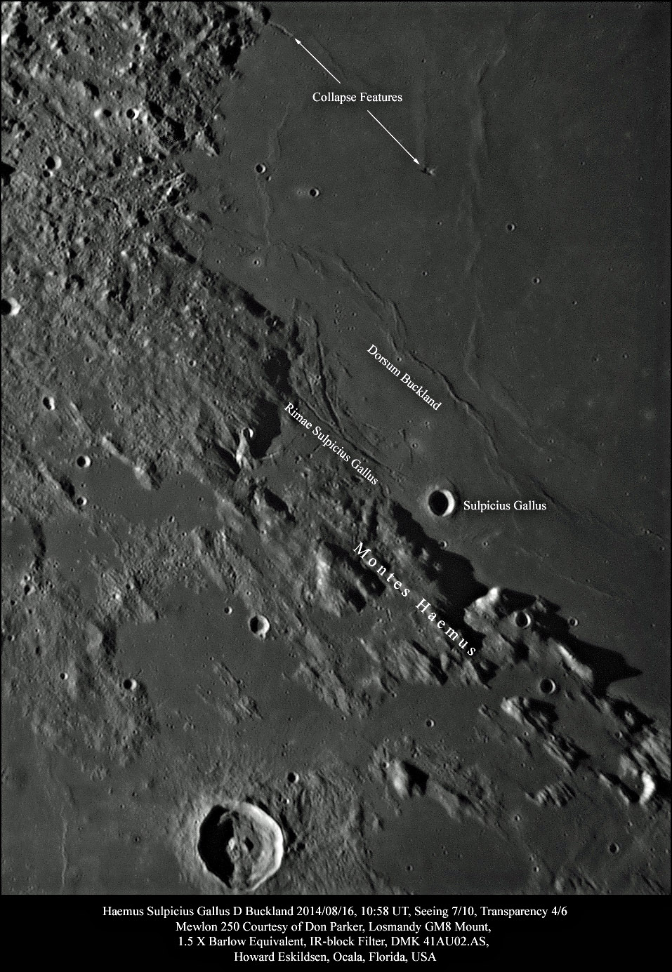
At the bottom of the image the scoured remains of the southwestern rim of Mare Serenitatis appear as the Haemus Mountains. The direction of flow of the energetic ejecta from Imbrium (northwest of this image) is obvious from the shape of the modified mounds. Comparison of these scarred mountains with the rubble descending from the Apennines (visible on the upper left of the image) reveals the gradation of energy of the Imbrium ejecta. The most energetic ejecta raged across the Haemus landscape and feathered out distal to those mountains, while the less energetic ejecta piled up as the tapering remnants of the Apennines and buried part of the original Serenitatis rim. <br /> | At the bottom of the image the scoured remains of the southwestern rim of Mare Serenitatis appear as the Haemus Mountains. The direction of flow of the energetic ejecta from Imbrium (northwest of this image) is obvious from the shape of the modified mounds. Comparison of these scarred mountains with the rubble descending from the Apennines (visible on the upper left of the image) reveals the gradation of energy of the Imbrium ejecta. The most energetic ejecta raged across the Haemus landscape and feathered out distal to those mountains, while the less energetic ejecta piled up as the tapering remnants of the Apennines and buried part of the original Serenitatis rim. <br /> | ||
| Line 10: | Line 11: | ||
Finally, two curious collapse features are noted in this image. The lower one appears nearly stellate and lies at the southern end of a small wrinkle ridge. The upper left linear collapse feature looks like a crater chain on this image, but review on the QuickMap reveals its true nature. Further scanning of the image and of QuickMap show other collapse features as well. <br /> | Finally, two curious collapse features are noted in this image. The lower one appears nearly stellate and lies at the southern end of a small wrinkle ridge. The upper left linear collapse feature looks like a crater chain on this image, but review on the QuickMap reveals its true nature. Further scanning of the image and of QuickMap show other collapse features as well. <br /> | ||
<br /> | <br /> | ||
| − | <em>[mailto:howardeskildsen@msn.com | + | <em>[mailto:howardeskildsen@msn.com Howard Eskildsen]</em><br /> |
<br /> | <br /> | ||
<strong>Related Links</strong><br /> | <strong>Related Links</strong><br /> | ||
| − | <em>[ | + | <em>[[21st Century Atlas of the Moon|21st Century Atlas]]</em> chart 11.<br /> |
<br /> | <br /> | ||
| + | <p><b>Yesterday's LPOD:</b> [[September 30, 2014|Preaching To the Choir]] </p> | ||
| + | <p><b>Tomorrow's LPOD:</b> [[October 2, 2014|Ring of Fire]] </p> | ||
<hr /> | <hr /> | ||
| + | {{wiki/ArticleFooter}} | ||
Latest revision as of 07:35, 28 October 2018
Scars, Wrinkles and Pits (and Ina, Too)

image by Howard Eskildsen, Florida
At the bottom of the image the scoured remains of the southwestern rim of Mare Serenitatis appear as the Haemus Mountains. The direction of flow of the energetic ejecta from Imbrium (northwest of this image) is obvious from the shape of the modified mounds. Comparison of these scarred mountains with the rubble descending from the Apennines (visible on the upper left of the image) reveals the gradation of energy of the Imbrium ejecta. The most energetic ejecta raged across the Haemus landscape and feathered out distal to those mountains, while the less energetic ejecta piled up as the tapering remnants of the Apennines and buried part of the original Serenitatis rim.
Farther north, the crater Sulpicius Gallus and rilles of the same name mark the margin of Serenitatis. Gaius Sulpicius Gallus was a Roman general, statesman and astronomer. Wikipedia describes him as having commanded the 2nd legion in the campaign against Perseus, king of Macedonia and gained great reputation for having predicted an eclipse of the moon on the night before the Battle of Pydna (168 BC). He was quoted by Pliny as an expert in astronomy.
The rille has an arcuate appearance on the margin of the mare caused by settling of the massive mare lava. Most likely, this same settling led to the compressive forces that created Dorsum Buckland to the upper right of the rill.
Finally, two curious collapse features are noted in this image. The lower one appears nearly stellate and lies at the southern end of a small wrinkle ridge. The upper left linear collapse feature looks like a crater chain on this image, but review on the QuickMap reveals its true nature. Further scanning of the image and of QuickMap show other collapse features as well.
Howard Eskildsen
Related Links
21st Century Atlas chart 11.
Yesterday's LPOD: Preaching To the Choir
Tomorrow's LPOD: Ring of Fire
COMMENTS?
Register, Log in, and join in the comments.


