Difference between revisions of "September 17, 2014"
| (4 intermediate revisions by the same user not shown) | |||
| Line 1: | Line 1: | ||
__NOTOC__ | __NOTOC__ | ||
| − | =Another Pyroclastic ?= | + | =Another Pyroclastic?= |
| + | <!-- Start of content --> | ||
<!-- ws:start:WikiTextHeadingRule:0:<h1> --> | <!-- ws:start:WikiTextHeadingRule:0:<h1> --> | ||
<!-- ws:start:WikiTextLocalImageRule:6:<img src="/file/view/LPOD-Sep17-14.jpg/522548358/LPOD-Sep17-14.jpg" alt="" title="" /> -->[[File:LPOD-Sep17-14.jpg|LPOD-Sep17-14.jpg]]<!-- ws:end:WikiTextLocalImageRule:6 --><br /> | <!-- ws:start:WikiTextLocalImageRule:6:<img src="/file/view/LPOD-Sep17-14.jpg/522548358/LPOD-Sep17-14.jpg" alt="" title="" /> -->[[File:LPOD-Sep17-14.jpg|LPOD-Sep17-14.jpg]]<!-- ws:end:WikiTextLocalImageRule:6 --><br /> | ||
| Line 13: | Line 14: | ||
<br /> | <br /> | ||
<strong>Related Links</strong><br /> | <strong>Related Links</strong><br /> | ||
| − | <em>[ | + | <em>[[21st Century Atlas of the Moon|21st Century Atlas]]</em> chart 17.<br /> |
<br /> | <br /> | ||
| + | <p><b>Yesterday's LPOD:</b> [[September 16, 2014|Odd Interiors]] </p> | ||
| + | <p><b>Tomorrow's LPOD:</b> [[September 18, 2014|Looking East]] </p> | ||
<hr /> | <hr /> | ||
| + | {{wiki/ArticleFooter}} | ||
Latest revision as of 07:36, 28 October 2018
Another Pyroclastic?

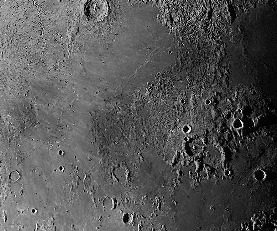
image by Gerard Coute, Chateaugay, France.
Here is an image taken this morning. It’s a large view centered on the area south of Sinus Aestuum. Contrast have been enhanced to show the dark pyroclastic surfaces and shades of gray on mare materials (east Schröter). I knew both pyroclastics areas east sinus (Bode pyro) and north sinus (Aestuum pyro) but I never noticed so obviously the area north of Gambart. Is this a pyroclastic zone uncovered by Copernicus ejecta? Southeast of Aestuum pyro area is a dark patch of mare materials (USGS) - 28 km large, 200 m depth. LRO nomenclature is Schroter F. Datas with LRO altimetry from a 80 km cross section shows something like a very old battered crater but I don’t think so; according to its shape, it should be older than Montes Apenninus... A lava filled graben? Two tectonic rimae cut the patch but the intersection is under lava. Eastern starts 85 km east, near Pallas A. Two wrinkles ridges crossing from Sinus Aestuum to Gambart are interesting; the southern one looks like hair braids and the end of each ridge looks like a wrinkle ridge "en echelons’’. There would be many things to add : Copernicus secondary craters, steep terrain northwest Aestuum pyro (-500 m in 5 km), irregularly shaped craters, lava filled craters, volcanic Rima Bode ... Large view have also great interest and are, sometimes, easier to take.
Gerard Coute
Technical Details
09/16/2014; 3h50 UT. Takahashi Mewlon 210 at f/d 11.5. DMK 31 camera. 300 images/3000. Proceeded AS2 and Registax 6.
Related Links
21st Century Atlas chart 17.
Yesterday's LPOD: Odd Interiors
Tomorrow's LPOD: Looking East
COMMENTS?
Register, Log in, and join in the comments.


