Difference between revisions of "August 24, 2013"
| (3 intermediate revisions by the same user not shown) | |||
| Line 1: | Line 1: | ||
__NOTOC__ | __NOTOC__ | ||
=Leibnitz Mountains?= | =Leibnitz Mountains?= | ||
| + | <!-- Start of content --> | ||
<!-- ws:start:WikiTextHeadingRule:0:<h1> --> | <!-- ws:start:WikiTextHeadingRule:0:<h1> --> | ||
<!-- ws:start:WikiTextLocalImageRule:6:<img src="/file/view/LPOD-Aug24-13.jpg/446361182/LPOD-Aug24-13.jpg" alt="" title="" /> -->[[File:LPOD-Aug24-13.jpg|LPOD-Aug24-13.jpg]]<!-- ws:end:WikiTextLocalImageRule:6 --><br /> | <!-- ws:start:WikiTextLocalImageRule:6:<img src="/file/view/LPOD-Aug24-13.jpg/446361182/LPOD-Aug24-13.jpg" alt="" title="" /> -->[[File:LPOD-Aug24-13.jpg|LPOD-Aug24-13.jpg]]<!-- ws:end:WikiTextLocalImageRule:6 --><br /> | ||
<em>image by [mailto:aerts.leo@skynet.be Leo Aerts], Belgium</em><br /> | <em>image by [mailto:aerts.leo@skynet.be Leo Aerts], Belgium</em><br /> | ||
<br /> | <br /> | ||
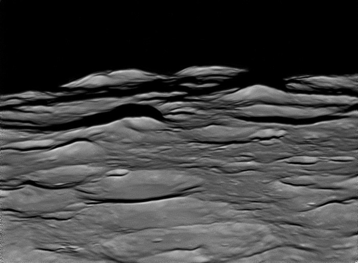
| − | There used to be a range of mountains called the Leibnitz Mountains. But somewhere along the way (actually a 1971 IAU meeting run by a solar astronomer with no regard for the history of lunar studies) that designation was lost because of uncertainy of what exactly it refered to. Leo has labelled his excellent image of part of the South Polar region <em>Leibnitz Mountains</em>, and they may be. Jim Mosher has made a careful [ | + | There used to be a range of mountains called the Leibnitz Mountains. But somewhere along the way (actually a 1971 IAU meeting run by a solar astronomer with no regard for the history of lunar studies) that designation was lost because of uncertainy of what exactly it refered to. Leo has labelled his excellent image of part of the South Polar region <em>Leibnitz Mountains</em>, and they may be. Jim Mosher has made a careful [https://the-moon.us/wiki/Montes_Leibnitz investigation] of what Schröter meant when he gave that name, but various later selenographers confused the issue, perhaps especially Miss. Mary Blagg, whose heart and intent were good, but whose draught(wo)manship of the 1935 IAU [https://the-moon.us/wiki/Wesley_%26_Blagg_-_1 map] was poor. So I am not going to say these are the Leibnitz, nor which ones they might be, because I have erred in past LPODs. So, as infuriating math textbooks used to state, <em>It is left as an exercise for the student to solve this problem.</em> In fact, it would be a valuable contribution to pin down which peak is which, following Schröter or [https://the-moon.us/wiki/Whitaker%2C_1954 Whitaker], using the LRO south polar mosaic. This is of more than historical interest because these peaks are presumably segments of the outer rim of the South Pole-Aitken Basin, and it would be useful to map in detail where that rim is.<br /> |
<br /> | <br /> | ||
<em>[mailto:tychocrater@yahoo.com Chuck Wood]</em><br /> | <em>[mailto:tychocrater@yahoo.com Chuck Wood]</em><br /> | ||
| Line 13: | Line 14: | ||
<br /> | <br /> | ||
<strong>Related Links</strong><br /> | <strong>Related Links</strong><br /> | ||
| − | <em>[ | + | <em>[[21st Century Atlas of the Moon|21st Century Atlas]]</em> chart L4.<br /> |
<br /> | <br /> | ||
<p><b>Yesterday's LPOD:</b> [[August 23, 2013|Floor-Elevated Craters]] </p> | <p><b>Yesterday's LPOD:</b> [[August 23, 2013|Floor-Elevated Craters]] </p> | ||
Latest revision as of 07:24, 28 October 2018
Leibnitz Mountains?

image by Leo Aerts, Belgium
There used to be a range of mountains called the Leibnitz Mountains. But somewhere along the way (actually a 1971 IAU meeting run by a solar astronomer with no regard for the history of lunar studies) that designation was lost because of uncertainy of what exactly it refered to. Leo has labelled his excellent image of part of the South Polar region Leibnitz Mountains, and they may be. Jim Mosher has made a careful investigation of what Schröter meant when he gave that name, but various later selenographers confused the issue, perhaps especially Miss. Mary Blagg, whose heart and intent were good, but whose draught(wo)manship of the 1935 IAU map was poor. So I am not going to say these are the Leibnitz, nor which ones they might be, because I have erred in past LPODs. So, as infuriating math textbooks used to state, It is left as an exercise for the student to solve this problem. In fact, it would be a valuable contribution to pin down which peak is which, following Schröter or Whitaker, using the LRO south polar mosaic. This is of more than historical interest because these peaks are presumably segments of the outer rim of the South Pole-Aitken Basin, and it would be useful to map in detail where that rim is.
Chuck Wood
Technical Details
August 21st 2013 about 0h50 UT. C14 + 2.5x powermate, redfilter, dispersion corrector and DMK 21AU618.
Related Links
21st Century Atlas chart L4.
Yesterday's LPOD: Floor-Elevated Craters
Tomorrow's LPOD: 50 Year Old Red Spots
COMMENTS?
Register, Log in, and join in the comments.


