Difference between revisions of "July 22, 2004"
(Created page with "__NOTOC__ =Huge Fractures= ---- ===COMMENTS?=== Click on this icon image:PostIcon.jpg at the upper right to post a comment.") |
|||
| (13 intermediate revisions by the same user not shown) | |||
| Line 1: | Line 1: | ||
__NOTOC__ | __NOTOC__ | ||
=Huge Fractures= | =Huge Fractures= | ||
| − | + | <!-- Start of content --> | |
| − | + | <table width="85%" border="0" align="center" cellpadding="6" cellspacing="2"> | |
| − | + | <tr> | |
| − | ---- | + | </tr> |
| − | === | + | </table> |
| − | + | <table width="85%" border="0" align="center" cellpadding="6" cellspacing="2"> | |
| + | <tr> | ||
| + | <td colspan="2"><div align="center"> | ||
| + | {{HoverImage|LPOD-2004-07-22.jpeg|LPOD-2004-07-22b.jpeg}} | ||
| + | </div></td> | ||
| + | </tr> | ||
| + | </table> | ||
| + | <table width="100%" border="0" cellpadding="8"> | ||
| + | <tr> | ||
| + | <td><div align="center"><p>Image Credit: [mailto:bobbotts@cogeco.ca Bob Botts]</p></div></td> | ||
| + | </tr> | ||
| + | </table> | ||
| + | <table class="story" border="0" bgcolor="#FFFFFF" width="90%" cellpadding="10" align="center"><tr><td> | ||
| + | <p class="story" align="center"><b>Huge Fractures</b></p> | ||
| + | <p class="story" align="left"> | ||
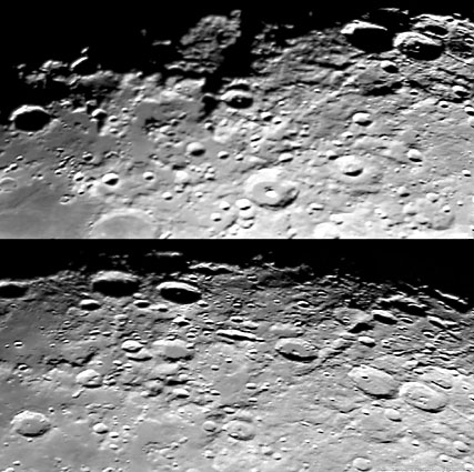
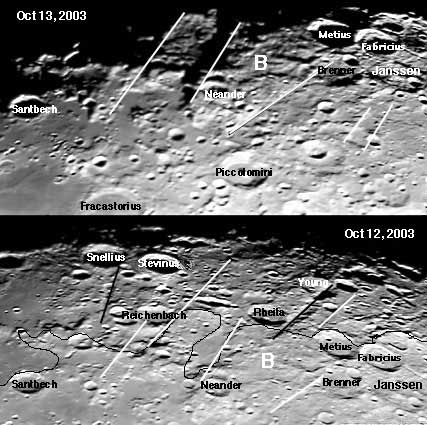
| + | These images are remarkable in showing the tectonic structure southeast of Mare Nectaris. And because Bob Botts took images on successive nights of the waning Moon we can see the same area illuminated and then deeply shadowed. The area SE of Nectaris is well known for its strong and conspicuous radial basin structures. Both the Snellius and Rheita Valleys (black lines on mouseover) are large secondary crater chains caused by mountainous blocks ejected during the formation of the Nectaris impact basin. But Bott's image shows other larger dislocations of the crust also radial to Nectaris. The Oct. 13 view shows a big slab of ground (labeled B for block) that casts a shadow to the north and is bounded on the south by a long, bright line that passes through Brenner. Block B appears to be fault-bounded and higher than the surfaces to its north and south. The previous night's view (remember these are sunset images so the terminator hides land to the east every night) reveals that the low land to the north of block B is partially flat and covered with smooth material. This makes sense, for mare lavas - or other flows - would be expected in lowlands. If block B did move differentially compared to its surroundings then it is one of the largest such blocks on the Moon - except for the truly gigantic circular faults like the Apennines and Altai that define impact basins.</p> | ||
| + | <blockquote> | ||
| + | <p align="right" class="story">— [mailto:tychocrater@yahoo.com Chuck Wood]</p></blockquote> | ||
| + | <p class="story"><b>Technical Details:</b><br> | ||
| + | October 12 and 13, 2003. 12" SCT f10 with Toucam webcam, processed using Registax</p> | ||
| + | <p class="story"><b>Related Links:</b> <br> | ||
| + | [http://www.lpi.usra.edu/research/lunar_orbiter/images/aimg/iv_064_h3.jpg Lunar Orbiter IV View] (notice fault)</p> | ||
| + | <p><b>Yesterday's LPOD:</b> [[July 21, 2004|Taurus-Littrow Route Map]] </p> | ||
| + | <p><b>Tomorrow's LPOD:</b> [[July 23, 2004|Sun, Moon and Stars]] </p> | ||
| + | </tr> | ||
| + | </table> | ||
| + | <!-- start bottom --> | ||
| + | <table width="100%" border="0" cellspacing="2" cellpadding="4"> | ||
| + | <tr> | ||
| + | <td><hr></td> | ||
| + | </tr> | ||
| + | <tr> | ||
| + | <td><p align="center" class="main_titles"><b>Author & Editor:</b><br> | ||
| + | [mailto:tychocrater@yahoo.com Charles A. Wood]</p> | ||
| + | <!-- Cleanup of credits --> | ||
| + | <!-- Cleanup of credits --> | ||
| + | <!-- Cleanup of credits --> | ||
| + | <!-- Cleanup of credits --> | ||
| + | <!-- Cleanup of credits --> | ||
| + | <!-- Cleanup of credits --> | ||
| + | <!-- Cleanup of credits --> | ||
| + | </tr> | ||
| + | </table> | ||
| + | <!-- end cal --> | ||
| + | <div align="center"></div> | ||
| + | <p> </p> | ||
| + | <!-- End of content --> | ||
| + | {{wiki/ArticleFooter}} | ||
Latest revision as of 21:42, 8 February 2015
Huge Fractures
Image Credit: Bob Botts |
|
Huge Fractures These images are remarkable in showing the tectonic structure southeast of Mare Nectaris. And because Bob Botts took images on successive nights of the waning Moon we can see the same area illuminated and then deeply shadowed. The area SE of Nectaris is well known for its strong and conspicuous radial basin structures. Both the Snellius and Rheita Valleys (black lines on mouseover) are large secondary crater chains caused by mountainous blocks ejected during the formation of the Nectaris impact basin. But Bott's image shows other larger dislocations of the crust also radial to Nectaris. The Oct. 13 view shows a big slab of ground (labeled B for block) that casts a shadow to the north and is bounded on the south by a long, bright line that passes through Brenner. Block B appears to be fault-bounded and higher than the surfaces to its north and south. The previous night's view (remember these are sunset images so the terminator hides land to the east every night) reveals that the low land to the north of block B is partially flat and covered with smooth material. This makes sense, for mare lavas - or other flows - would be expected in lowlands. If block B did move differentially compared to its surroundings then it is one of the largest such blocks on the Moon - except for the truly gigantic circular faults like the Apennines and Altai that define impact basins. Technical Details: Related Links: Yesterday's LPOD: Taurus-Littrow Route Map Tomorrow's LPOD: Sun, Moon and Stars |
Author & Editor: |
COMMENTS?
Register, Log in, and join in the comments.


