Difference between revisions of "October 8, 2014"
| Line 1: | Line 1: | ||
__NOTOC__ | __NOTOC__ | ||
=Flat To the Limb= | =Flat To the Limb= | ||
| + | <!-- Start of content --> | ||
<!-- ws:start:WikiTextHeadingRule:0:<h1> --> | <!-- ws:start:WikiTextHeadingRule:0:<h1> --> | ||
<!-- ws:start:WikiTextLocalImageRule:6:<img src="/file/view/LPOD-Oct8-14.jpg/525544700/LPOD-Oct8-14.jpg" alt="" title="" /> -->[[File:LPOD-Oct8-14.jpg|LPOD-Oct8-14.jpg]]<!-- ws:end:WikiTextLocalImageRule:6 --><br /> | <!-- ws:start:WikiTextLocalImageRule:6:<img src="/file/view/LPOD-Oct8-14.jpg/525544700/LPOD-Oct8-14.jpg" alt="" title="" /> -->[[File:LPOD-Oct8-14.jpg|LPOD-Oct8-14.jpg]]<!-- ws:end:WikiTextLocalImageRule:6 --><br /> | ||
Revision as of 16:19, 8 February 2015
Flat To the Limb

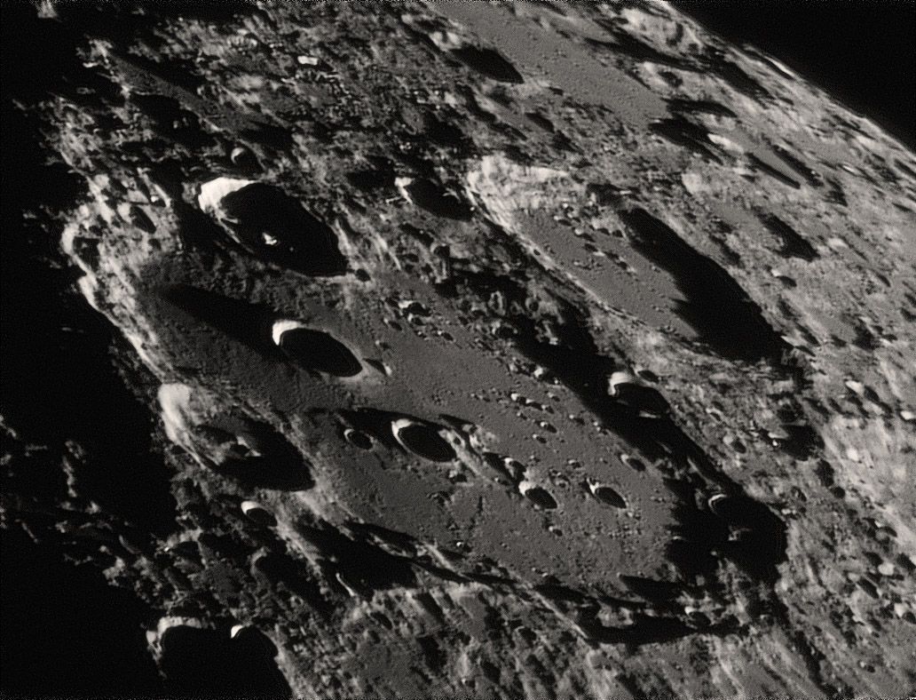
image by Leo Aerts, Belgium
Wow. Is this the view out a spacecraft window, racing towards the limb and then over to the far side in a polar orbit? The view shows a series of flat-floored craters interspersed among more rugged terrain. The contrast between the relatively smooth crater floors and the rough surroundings raises a issue that has bothered me for 30 years. The smooth fill that shallows many older craters is considered to be composed of two sources of material. First is wall debris that slides downslope soon after craters were formed and through time as subsequent impacts jiggled the surface. But the main infill is widely believed to be from basin ejecta, with Orientale being the most recent source. If you calculate how deep these craters were when first formed - based on analyses of more recent craters that haven't been degraded, you will discover that the infill is typically one to two kilometer deep. That might well have happened, especially close to basins. But the surrounding terrain, which is older than the flat-floored craters must have received the same smothering deposits, but don't seem to have been widely covered, except in small ponds like those at the bottom right edge of Leo's image. It is hard to accept that the fill is basin ejecta. If not, volcanism has been the alternative interpretation, at least a few decades ago. But the smooth material does not have the same composition as lunar maria or some of the more silicic material as in the Gruithuisen Domes. And there are no morphological evidences for volcanic landforms. Of course, if there were volcanism in the craters it would be ancient, and small volcanic landforms would have been eroded away. We don't know what the smooth stuff is.
Chuck Wood
Technical Details
September 17th 2014 with a Celestron 14" 1.8x barlow projection, red filter, dispersion corrector and webcam DMK31AU03.
Related Links
21st Century Atlas chart 15.
Yesterday's LPOD: Who is the Woman in the Moon?
Tomorrow's LPOD: Little Visible Things
COMMENTS?
Register, Log in, and join in the comments.


