Difference between revisions of "May 6, 2005"
| Line 8: | Line 8: | ||
<table width="85%" border="0" align="center" cellpadding="6" cellspacing="2"> | <table width="85%" border="0" align="center" cellpadding="6" cellspacing="2"> | ||
<tr><td colspan="2" valign="top"><div align="center"> | <tr><td colspan="2" valign="top"><div align="center"> | ||
| − | + | [[File:LPOD-2005-05-06.jpeg|LPOD-2005-05-06.jpeg]] | |
</div></td> | </div></td> | ||
</tr> | </tr> | ||
| Line 20: | Line 20: | ||
<table class="story" border="0" bgcolor="#FFFFFF" width="90%" cellpadding="10" align="center"><tr><td> | <table class="story" border="0" bgcolor="#FFFFFF" width="90%" cellpadding="10" align="center"><tr><td> | ||
<p align="center"><b>A Handy New Map</b></p> | <p align="center"><b>A Handy New Map</b></p> | ||
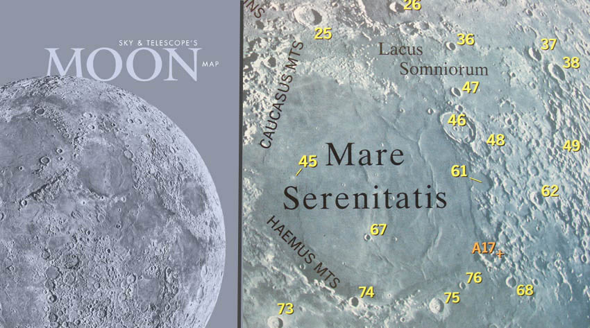
| − | <p align="left">For a thousand years, or at least a few decades, <i>Sky & Telescope</i> has sold a small blue map of the Moon, originally published (as <i>Mappa Selenographica</i>) in 1926 by the Czech selenographer Karel Andel. Sky has recently replaced that venerable map with a new imagemap that more naturally depicts the lunar surface than any previous map. This is possible because the base of the new chart is the remarkable composite image assembled by Pablo Lonnie Pacheco Railey of Mexico. Pablos amazing imagemap was first revealed on [ | + | <p align="left">For a thousand years, or at least a few decades, <i>Sky & Telescope</i> has sold a small blue map of the Moon, originally published (as <i>Mappa Selenographica</i>) in 1926 by the Czech selenographer Karel Andel. Sky has recently replaced that venerable map with a new imagemap that more naturally depicts the lunar surface than any previous map. This is possible because the base of the new chart is the remarkable composite image assembled by Pablo Lonnie Pacheco Railey of Mexico. Pablos amazing imagemap was first revealed on [[March_23,_2004|LPOD]] and is rapidly becoming the standard lunarimage. Pablo constructed it by merging together 150 low sun images from the [http://www.lpi.usra.edu/resources/cla/ online] version of the [[August_11,_2004|Consolidated Lunar Atlas.]] The new map is 8.5 x 11 and includes an 8diameter Moon and a key to the 280 craters identified by numbers. The maria, major mountains and Apollo landing sites are also indicated. The chart is available in paper and laminated versions, and a North up version, as seen here, and East and West reversed version for users of refractors and Schmidt-Cassegrain telescopes and right angle mirrors. If you need a small map to help identify the main named craters at the telescope or on an image this may be for you.</p> |
<blockquote><p align="right">— [mailto:tychocrater@yahoo.com Chuck Wood]</blockquote> | <blockquote><p align="right">— [mailto:tychocrater@yahoo.com Chuck Wood]</blockquote> | ||
<p align="left"><p><b>Related Links:</b><br> | <p align="left"><p><b>Related Links:</b><br> | ||
| Line 38: | Line 38: | ||
[mailto:anthony@perseus.gr Anthony Ayiomamitis]</p> | [mailto:anthony@perseus.gr Anthony Ayiomamitis]</p> | ||
<p align="center" class="main_titles"><b>Contact Translator:</b><br> | <p align="center" class="main_titles"><b>Contact Translator:</b><br> | ||
| − | [mailto:pablolonnie@yahoo.com.mx | + | [mailto:pablolonnie@yahoo.com.mx Pablo Lonnie Pacheco Railey] (Es)<br> |
| − | [mailto:chlegrand@free.fr | + | [mailto:chlegrand@free.fr Christian Legrand] (Fr)</p> |
<p align="center" class="main_titles"><b>[mailto:webuser@observingthesky.org Contact Webmaster]</b></p> | <p align="center" class="main_titles"><b>[mailto:webuser@observingthesky.org Contact Webmaster]</b></p> | ||
<p align="center" class="main_titles"><b>A service of:</b><br> | <p align="center" class="main_titles"><b>A service of:</b><br> | ||
| − | [http://www.observingthesky.org/ | + | [http://www.observingthesky.org/ ObservingTheSky.Org]</p> |
<p align="center" class="main_titles"><b>Visit these other PODs:</b> <br> | <p align="center" class="main_titles"><b>Visit these other PODs:</b> <br> | ||
| − | [http://antwrp.gsfc.nasa.gov/apod/astropix.html | + | [http://antwrp.gsfc.nasa.gov/apod/astropix.html Astronomy] | [http://www.msss.com/ Mars] | [http://epod.usra.edu/ Earth]</p> |
</td></tr> | </td></tr> | ||
</table> | </table> | ||
Revision as of 14:32, 17 January 2015
A Handy New Map
<nobr>A Handy New Map</nobr> |
Image Credit: Sky & Telescope
|
|
A Handy New Map For a thousand years, or at least a few decades, Sky & Telescope has sold a small blue map of the Moon, originally published (as Mappa Selenographica) in 1926 by the Czech selenographer Karel Andel. Sky has recently replaced that venerable map with a new imagemap that more naturally depicts the lunar surface than any previous map. This is possible because the base of the new chart is the remarkable composite image assembled by Pablo Lonnie Pacheco Railey of Mexico. Pablos amazing imagemap was first revealed on LPOD and is rapidly becoming the standard lunarimage. Pablo constructed it by merging together 150 low sun images from the online version of the Consolidated Lunar Atlas. The new map is 8.5 x 11 and includes an 8diameter Moon and a key to the 280 craters identified by numbers. The maria, major mountains and Apollo landing sites are also indicated. The chart is available in paper and laminated versions, and a North up version, as seen here, and East and West reversed version for users of refractors and Schmidt-Cassegrain telescopes and right angle mirrors. If you need a small map to help identify the main named craters at the telescope or on an image this may be for you. Related Links: Tomorrow's LPOD: Buried and Textured |
|
Author & Editor: Technical Consultant: Contact Translator: A service of: |
COMMENTS?
Register, and click on the Discussion tab at the top of the page.


