Difference between revisions of "September 7, 2004"
| Line 12: | Line 12: | ||
<tr> | <tr> | ||
<td colspan="2" valign="top"><div align="center"> | <td colspan="2" valign="top"><div align="center"> | ||
| − | + | [[File:LPOD-2004-09-07.jpeg|LPOD-2004-09-07.jpeg]] | |
</div></td> | </div></td> | ||
</tr> | </tr> | ||
| Line 25: | Line 25: | ||
<p class="story" align="center"><b>Helen's Husband</b></p> | <p class="story" align="center"><b>Helen's Husband</b></p> | ||
<p class="story" align="left"> | <p class="story" align="left"> | ||
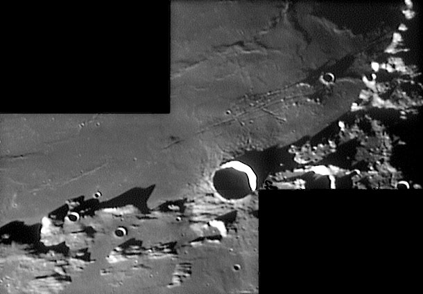
| − | Although the lunar crater Menelaus is named for a Greek astronomer in ancient Alexandria, I prefer to think instead of another Menelaus, the warrior husband of Helen of Troy. The lunar Menelaus is a 27 km wide, 2.6 km deep crater straddling the rim of the Serenitatis basin and the mare that fills the basin. If the mare really were an ocean of water, Menelaus would be the castle guarding this stretch of the coast. But the real interest here is the cluster of rilles just north of Menelaus. These Menelaus Rilles are in the older and darker [ | + | Although the lunar crater Menelaus is named for a Greek astronomer in ancient Alexandria, I prefer to think instead of another Menelaus, the warrior husband of Helen of Troy. The lunar Menelaus is a 27 km wide, 2.6 km deep crater straddling the rim of the Serenitatis basin and the mare that fills the basin. If the mare really were an ocean of water, Menelaus would be the castle guarding this stretch of the coast. But the real interest here is the cluster of rilles just north of Menelaus. These Menelaus Rilles are in the older and darker [[August_27,_2004|annulus]] of Serenitatis lavas. There seem to be two families of rilles - first are the three to four strands of rilles that parallel the basin rim. These probably formed by cracking as the mare-heavy center of Serenitatis subsided. Nearly at right angle to these narrow rilles are two or three shorter rilles that are partially lines of collapse pits - see Lunar Orbiter image for details. KC's low sun image reveals that the western most of the rilles cuts thru the middle of a low dome. The [http://www.glrgroup.org/domes/mapdome/c3.htm ALPO dome map] shows six possible domes in this region, but KC's great image renders that number questionable. |
<blockquote> | <blockquote> | ||
<p align="right"> — [mailto:tychocrater@yahoo.com Chuck Wood ]</p> | <p align="right"> — [mailto:tychocrater@yahoo.com Chuck Wood ]</p> | ||
Revision as of 13:55, 17 January 2015
Helen's Husband
Helen's Husband |
Image Credit: K.C. Pau |
|
Helen's Husband Although the lunar crater Menelaus is named for a Greek astronomer in ancient Alexandria, I prefer to think instead of another Menelaus, the warrior husband of Helen of Troy. The lunar Menelaus is a 27 km wide, 2.6 km deep crater straddling the rim of the Serenitatis basin and the mare that fills the basin. If the mare really were an ocean of water, Menelaus would be the castle guarding this stretch of the coast. But the real interest here is the cluster of rilles just north of Menelaus. These Menelaus Rilles are in the older and darker annulus of Serenitatis lavas. There seem to be two families of rilles - first are the three to four strands of rilles that parallel the basin rim. These probably formed by cracking as the mare-heavy center of Serenitatis subsided. Nearly at right angle to these narrow rilles are two or three shorter rilles that are partially lines of collapse pits - see Lunar Orbiter image for details. KC's low sun image reveals that the western most of the rilles cuts thru the middle of a low dome. The ALPO dome map shows six possible domes in this region, but KC's great image renders that number questionable. Technical Details: Related Links: Tomorrow's LPOD: Where in the Moon is Nielson?
|
Author & Editor: Technical Consultant: Contacte al Traductor: A service of: |
COMMENTS?
Register, and click on the Discussion tab at the top of the page.


